Download
1 / 1
10 likes | 132 Views
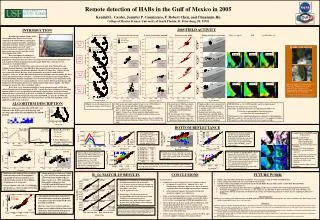
Remote detection of HABs in the Gulf of Mexico in 2005 Kendall L. Carder, Jennifer P. Cannizzaro, F. Robert Chen, and Chuanmin Hu College of Marine Science, University of South Florida, St. Petersburg, FL 33701. 2005 FIELD ACTIVITY. INTRODUCTION.

E N D
Remote detection of HABs in the Gulf of Mexico in 2005 Kendall L. Carder, Jennifer P. Cannizzaro, F. Robert Chen, and Chuanmin Hu College of Marine Science, University of South Florida, St. Petersburg, FL 33701 2005 FIELD ACTIVITY INTRODUCTION Chlor_a_3 (mg m-3) FLH bbp(550)/Chlor_a_3 Harmful algal blooms (HABs) of the toxic dinoflagellate Karenia brevis occur regularly in the Gulf of Mexico causing fish and marine mammal mortalities and human respiration irritation. Bloom concentrations above background levels (1-103 cells l-1) usually occur in late summer and fall and concentrate most heavily along the central West Florida Shelf (WFS). Based on shipboard radiometry, a method was developed to 1) classify K. brevis Jan. 19, 2005 HURRICANE WILMA 25 Apr. 05 25 Apr. 05 25 Apr. 05 WFS K. brevis bloom, October 2001 Photo courtesy of C.Heil April 25-28, 2005 populations with greater than 104 cells l-1 based on low backscattering-to-chlorophyll ratios and 2) quantify blooms using fluorescent line height (FLH) data (Cannizzaro et al., accepted; see description below). According Dr. Cynthia Heil, senior research scientist at the Florida Fish and Wildlife Research Institute, “[the 2005] Red Tide outbreak is the worst in the area since 1971 ”. In early January, the bloom originated ~30 miles off Tampa Bay. Manatee deaths were reported in March. By June, beach communities were littered with dead fish, stringrays, crabs, etc. In July, Hurricane Dennis made conditions worse by pushing the dead marine life further into bays and inlets. A month later, the bloom became trapped below a strong thermocline. Bottom communities were devastated when bacterial degradation of the dead organisms led to severe anoxic conditions. In late August, Hurricane Katrina provided temporary relief by mixing up the water columnreplenishing oxygen supplies. The bloom continued to persist (Nov.-Dec.) in offshore waters. Here, the K. brevis detection algorithm is tested using in situ and satellite data collected during four field experiments in 2005. A newly developed technique for classifying optically shallow waters and quantifying chlorophyll concentrations and backscattering coefficients more accurately in such waters is examined (Cannizzaro and Carder, accepted). Lastly, ship and spatially/temporally concurrent SeaWiFS Rrs(l) data for the WFS and Bahamas are compared to address how accurately these classification algorithms can be applied to satellite ocean color data. 21 October: pre-hurricane Aug. 24, 2005 25 October: post-hurricane Increased suspended sediments due to Hurricane Wilma led to increased backscattering which may have dampened the typical low b*bp signal exhibited by K. brevis blooms. 04 Nov. 05 04 Nov. 05 04 Nov. 05 Oct. 31- Nov. 4, 2005 (Hurricane Wilma MODIS imagery courtesy of Liam Gumley and Scott Bachmeier/UW-CIMSS) ALGORITHM DESCRIPTION • High K. brevis cell counts observed in January, August, and November • (left) in situ and (right) modeled (Carder et al., 1999) [Chl a] vs bbp(550) data shown with Morel (1988) relationship • January and April: data support ECOHAB (1999-2001) results (i.e. low b*bp inside blooms and high b*bp outside blooms) • August: Scrippsiella sp. bloom (non-toxic dinoflagellate) also exhibiting low b*bp observed in highly stratified surface waters overlying anoxic bottom waters • October-November: numerous false negatives due to residual high backscattering from Hurricane Wilma (24 Oct. ‘05) (see box on far right) • In situ [Chl a] vs FLH data shown with best-fit bloom (red dashed) and non-bloom (black solid) lines developed from ECOHAB data (1999-2001) • K. brevis blooms do not always exhibit low fluorescence efficiencies • Scrippsiella sp. blooms (Aug.) also exhibit low fluorescence efficiencies • Shipboard Rrs(l) data examined for bottom reflectance contamination (Cannizzaro and Carder, accepted) (see details below). • January and April data: mostly transitional (one optically shallow data point with [Chl a]=0.3 mg m-3) • August and November data: mostly optically deep or transitional • MODIS Chlor_a_3 (left), FLH (middle), and b*bp (right) imagery • January and August scenes were cloudy • Chl values in April and November are high along the WFS coast • Is this due to phytoplankton, bottom reflectance, or colored dissolved organic matter??? • FLH imagery shows which high-chl patches contain lots of phytoplankton • April b*bp values are low north of 28oN; K. brevis??? no samples to confirm • November b*bp values are low where K. brevis counts are high Multi-year, multi-season ship data (1999-2001) were collected on the WFS as part of the Ecology and Oceanography of Harmful Algal Blooms (ECOHAB) program. ECOHAB cruises (B=bloom present) BOTTOM REFLECTANCE • Median Rrs for Chl’s: 1-2 mg m-3 2-5 mg m-3 5-10 mg m-3 • K. brevis blooms are ~4x’s less reflective than non-K.brevis blooms. • Chl’s estimated from Rrs(490)/Rrs(555) (upper left) and bbp(550) values estimated from Rrs(555) (Carder et al., 1999) (lower left) are overestimated in optically shallow waters. • Estimating Chl’s for data classified as optically deep and optically shallow using best-fit Rrs(490)/Rrs(555) and Rrs(412)/Rrs(670) functions, respectively, and blending Chl’s for transitional waters to prevent algorithm-switching artifacts reduces the RMSlog error to 0.172 (n=451). • Application to SeaWiFS image (16 March 2002) Upper left: classified image white=optically deep, pink=transitional, and cyan=optically shallow Middle left: Chl’s derived using OC4v4 algorithm Lower left: Chl’s derived using new classification and quantification approach • Chl’s overestimated on the WFS and Bahama Banks using the OC4v4 algorithm appear more reasonable using the new shallow-water approach • Offshore Chl’s are similar for both algorithms In situ Modeled • Shipboard Rrs() data (n=451; 1998-2001) from the WFS and Bahamas were partitioned into water column and bottom reflectance spectra via optimization (Lee et al., 1999). • Data were sorted into four groups (<25%, 25-50%, 50-75%, and >75%) based on the contribution bottom reflectance makes to Rrs(555) • Classification criteria: “optically deep” data (white region), “transitional” data (light gray region), and “optically shallow” data (dark gray region). • For data classified as optically shallow, a power function (Rrs(555)=1.42*Rrs(670)0.77; r2=0.94, n=275) developed from optically deep data was used to estimate “bottom-free” Rrs(555) values • bbp’s were then estimated using the Carder et al. (1999) function from optically deep and “bottom-free” optically shallow Rrs(555) values (transitional data were blended) • Classifying and blending the data reduced the RMSlog error from 1.15 to 0.59 • Chl’s estimated from Rrs(412)/Rrs(670) (e.g. using wavelengths located outside the spectral transparency window)are derived more accurately for data sets containing optically shallow waters. (see Cannizzaro and Carder, accepted) • Similar patterns were observed when bbp(550) and Chl were modeled semi-analytically from shipboard Rrs(l) data (Carder et al., 1999) indicating that satellite radiometric data (SeaWiFS and MODIS) may be used to identify K. brevis blooms from space. • Modeling results indicate that particulate backscattering and NOT absorption is responsible for the four-fold decreased reflectivity observed in K. brevis blooms (Cannizzaro et al., accepted). • K. brevis blooms (>104 cells l-1) exhibit low chl-specific bbprelative to high-chl, diatom-dominated estuarine blooms. Rrs(l) MATCH-UP RESULTS CONCLUSIONS FUTURE WORK • Lessons learned: • In 2005, false negative flagging of K. brevis blooms occurred • for blooms of Scrippsiella sp.. Unlike K. brevis, this dinoflagellate is non-toxic. However, it’s affects on marine organisms when present in high concentrations is unknown. • in post-hurricane imagery when backscattering-rich suspended sediments were still present • Fluorescence line height imagery are useful in discriminating between true phytoplankton-rich regions and optically shallow waters or those containing high CDOM:phytoplankton ratios. • Due to uncertainty in Rrs(412) and Rrs(670) SeaWiFS data, both classification algorithms for K. brevis (Cannizzaro et al., accepted) and shallow water (Cannizzaro and Carder, accepted) that were developed using in situ datamay have to be refined in order to work with satellite data. • Where did January bloom go? Low b*bp found to N-NW in April was never sampled. A remnant of the January bloom? • Validate and refine HAB classification and shallow water techniques using SeaWiFS and MODIS data. • Collect additional field data in K. brevis and shallow waters blooms. • Continue collaborating with Dr. Chuanmin Hu and Dr. Frank Müller-Karger (USF) and Dr. Cynthia Heil (Florida FWRI). • Apply HAB classification technique to: • examine the inter-annual spatial and temporalvariability of Chl’s for past blooms and background phytoplankton populations, • determine the response of K. brevis blooms (i.e. size, frequency, and duration) to short-term climatic events such as El Niño, and • predict future blooms and through coordination with existing state monitoring programs to target discrete sampling locations more accurately. • Acknowledgements • Funding was provided by NASA (NNG04GL55G) with ONR (N00014-02-1-0211, N00014-04-1-0531) ship time. The authors would like to Dr. Gabriel Vargo (USF) and Dr. Cynthia Heil for the K. brevis cell count data. • References • Cannizzaro, J.P. and Carder K.L., Estimating chlorophyll a concentrations from remote-sensing reflectance data in optically shallow waters, Remote Sensing of Environment, accepted. • Cannizzaro, J.P., Carder, K.L., Chen, F.R., Heil, C.A., Vargo, G.A., A novel technique for detection of the toxic dinoflagellate, Karenia brevis, in the Gulf of Mexico from remotely sensed ocean color data. Continental Shelf Research, accepted. • Carder, K.L., Chen, F.R., Lee, Z.P., Hawes, S.K., Kamykowski, D., 1999. Semi-analytic Moderate-Resolution Imaging Spectrometer algorithms for chlorophyll a and absorption with bio-optical domains based on nitrate-depletion temperatures. Journal of Geophysical Research 104, 5403-5422. • Lee, Z., Carder, K.L., Mobley, C.D., Steward, R.G., Patch, J.S., 1999. Hyperspectral remote sensing for shallow waters: 2. Deriving bottom depths and water properties by optimization. Applied Optics 38, 3831-3843. • Morel, A., 1988. Optical modeling of the upper ocean in relation to its biogenous matter content (case I waters). Journal of Geophysical Research 93, 10,749-10,768. • Shipboard vs SeaWiFS Rrs(l) match-up results for WFS and Bahamas data (1998-2001) • r_sq decreases with decreasing wavelength (e.g. from Rrs(555) to Rrs(412)) due to uncertainty in atmospheric correction • Rrs(670) signal:noise is low • Implications: Classification criteria for detecting HABs and bottom reflectances from satellite ocean color data may need modifications since both techniques require Rrs(412) data and the shallow water technique also requires Rrs(670) data. • Chlorophyll concentrations in positively identified blooms can then be quantified using fluorescence line height (FLH) data provided by MODIS. • However, since K. brevis bloom and non-bloom waters exhibit differing fluorescence efficiencies, bloom identification prior to chlorophyll estimations is important. NOTE: Match-up data were generated by the Institute of Marine Remote Sensing at the University of South Florida using SeaWIFS HRPT LAC data. All in situ data are within +/-3 hours of the corresponding satellite overpass. For each location, a 3x3 box was used to extract the satellite data. The median value of all valid data within the 3x3 box is used. In situ