Download
1 / 16
190 likes | 530 Views
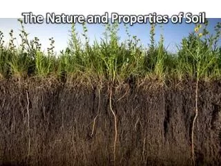
Properties of the Soil. Wt. Tn. Workshop-Liberty July. 13, 2005. Terms associated with soils. Texture of soil- The size of the soil particles that make up the soil. Drainage- The rapidity and extent of the removal of water from the soil.

E N D
Properties of the Soil Wt. Tn. Workshop-Liberty July. 13, 2005
Terms associated with soils • Texture of soil- The size of the soil particles that make up the soil. • Drainage- The rapidity and extent of the removal of water from the soil. • Limitations- Factors that affect the production of crops negatively.
Soils and land management Terms-continued Available water holding capacity- Amount of water that soil will hold and release for use by plants. Slope-The fall or incline of the land. Soil erosion-The carrying off of soil by water or wind.
Textures of the soil Soils continued • Coarse • Medium • Fine(not found in TN)
Depth of soil that is favorable for roots • Deep-36 inches or more • Moderately Deep-20-36 inches • Shallow-10-20 inches • Very Shallow-Less than 10 inches • The following are sections to choose from the Tennessee Soil Judging Card.
Classification of the level of internal drainage. • This refers to the rate that water moves through the soil. • Poorly Drained • Somewhat Poorly Drained • Moderately Well Drained • Well Drained • Excessively Drained
Available Water Holding Capacity • Texture of soil Average AWHC inches/inch • Coarse .05 • Medium .20 • Fine .15
AWHC continued • Example problem- Rooting zone is 36 inches. The top 15 inches is medium texture; the bottom 21 inches is fine texture. • 15x.20=3.00, 21x.15=3.15 total= 6.15 • AWHC AWHC Capacity in inches • Low Less than 4.0 • Medium 4.0 to less than 6.0 • High 6.0 or more
Soils-Cont. • Slope: • Effects the material being moved and material left behind by pulverizing it. • Exposes subsoil at the upper portion of the slope. • Effects the distribution of water on the Earth’s surface.
Soils continued - Middle and East TennesseeSlope ClassSlope RangeNearly level (A)0-2%Gently Sloping (B) 2-5% Sloping (C) 5-12% Moderately Steep (D) 12-20% Steep (E) 20-30%Very Steep (F) 30% or More
Slope Classes-West Tennessee • Slope ClassSlope Range • Nearly Level (A) 0-2% • Gently sloping (B) 2-5% • Sloping (C) 5-8% • Moderately steep (D) 8-12% • Steep (E) 12-20%
Landscape Positions • Flood Plain-Nearly level positions that are close to streams and bodies of water. • Footslopes- Areas at the base of a slope.usually separate flood plains from uplands and terraces. • Depression- Soils that have no open flow outlet for water. • Upland,or Terraces-Anything not following the above guidelines.
Determining Land Capability Class • Land capability classes are assigned based on slope,degree of erosion, internal drainage, depth, flooding, and other soil factors that limit plant growth. There are many possible combinations of these factors,and it is impossible to list them all. The following rules will cover most soil and landscape situations in Tennessee.
Table 1. Effect of slope and degree of erosion • Slope Class • Degree of erosion A B C D E F • Slight or moderate I II III IV VI VII • Severe II III IV VI VI VII
Limitations for Crop Production • Wetness- Mark if soil is not well drained. • Flooding- Depressions and Floodplains should be marked. • Slope- Mark if over 2 % or more. • Texture of surface soil- Mark if fine or course. • Texture of subsoil- Mark if course *Check soil judging book .
Crop Limitations- continued • Available water holding capacity – Mark if less than 6 inches in the rooting zone. • Rock fragments or rock outcrops- Mark these if either one of them are common or many. • Effective depth- Mark depth if it less than 30 inches for root penetration.