Download
1 / 20
200 likes | 432 Views
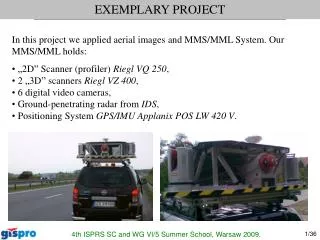
EXEMPLARY PROJECT. In this project we applied aerial images and MMS/MML System. Our MMS/MML holds: • „2D” Scanner (profiler) Riegl VQ 250 , • 2 „3D” scanners Riegl VZ 400 , • 6 digital video cameras, • Ground-penetrating radar from IDS , • Positioning System GPS/IMU Applanix POS LW 420 V.

E N D
EXEMPLARY PROJECT In this project we applied aerial images and MMS/MML System. Our MMS/MML holds: • „2D” Scanner (profiler) Riegl VQ 250,• 2 „3D” scanners Riegl VZ 400,• 6 digital video cameras,• Ground-penetrating radar from IDS,• Positioning System GPS/IMU Applanix POS LW 420 V. 4th ISPRS SC and WG VI/5 Summer School, Warsaw 2009.
EXEMPLARY PROJECT 4th ISPRS SC and WG VI/5 Summer School, Warsaw 2009.
EXEMPLARY PROJECT • Data acquired: • Coherent point cloud from 3 scanners, • Aerial photos with 5cm GSD (ground sample distance). • End products: • 3D Vector Base map for design purposes, accuracy XY < 3 cm, Z < 1 cm, • DTM (Digital Terrain Model) with accuracy 1 cm for the roadway and 20 cm for 250m buffer, • Orthophoto with a 5cm pixel size (GSD). • Vector Base map for design purposes has been made in 3 months for 85km of highway without stopping the traffic. 4th ISPRS SC and WG VI/5 Summer School, Warsaw 2009.
EXEMPLARY PROJECT Point cloud of the part of A1 Highway from VQ250 profiler scanner acquired in one direction DTM (shading) for A1 roadway (visible wheel track rutting) 4th ISPRS SC and WG VI/5 Summer School, Warsaw 2009.
EXEMPLARY PROJECT Processing RAW point cloud data in RiPRocess 4th ISPRS SC and WG VI/5 Summer School, Warsaw 2009.
EXEMPLARY PROJECT Fragment of an Orthophoto with a 5cm pixel size 4th ISPRS SC and WG VI/5 Summer School, Warsaw 2009.
EXEMPLARY PROJECT Fragment of the base map for design purposes 4th ISPRS SC and WG VI/5 Summer School, Warsaw 2009.
EXEMPLARY PROJECT Fragment of the TIN (Triangulated irregular network) 4th ISPRS SC and WG VI/5 Summer School, Warsaw 2009.
EXEMPLARY PROJECT 4th ISPRS SC and WG VI/5 Summer School, Warsaw 2009.
APPLICATION OF MLS/TLS IN FORESTRY Measuring directly on a point cloud: • Tree and stand basal area, • diameter on any given height above the ground (including breast height) • tree position • tree height Extracting: • Stem volume • Tree Biomass • 3D surface of stems 4th ISPRS SC and WG VI/5 Summer School, Warsaw 2009.
APPLICATION OF MLS/TLS IN FORESTRY Animation to illustrate the high-density point cloud data obtained from laser scanning Source: Guang Zheng The cross section of tree trunkSource: Wezyk P. et al. 4th ISPRS SC and WG VI/5 Summer School, Warsaw 2009.
APPLICATION OF MLS/TLS IN FORESTRY Tree profile extracted from mobile point cloud data, Source: ADS Inc. 4th ISPRS SC and WG VI/5 Summer School, Warsaw 2009.
APPLICATION OF MLS/TLS IN FORESTRY Visualization of point clouds, with the intensity, Source: Piotr Tompalski, Krystian Kozioł 4th ISPRS SC and WG VI/5 Summer School, Warsaw 2009.
APPLICATION OF MLS/TLS IN FORESTRY Curvature estimation of 3D point cloud surfaces Source: INRIA, GreenLab 4th ISPRS SC and WG VI/5 Summer School, Warsaw 2009.
APPLICATION OF MLS/TLS IN FORESTRY Reconstruction of tree crown shape from scanned data Source: INRIA, GreenLab 4th ISPRS SC and WG VI/5 Summer School, Warsaw 2009.
APPLICATION OF MLS/TLS IN FORESTRY Triangulated surface from point cloud data 4th ISPRS SC and WG VI/5 Summer School, Warsaw 2009.
DIFFRENT APPLICATION 4th ISPRS SC and WG VI/5 Summer School, Warsaw 2009.
DIFFRENT APPLICATION 4th ISPRS SC and WG VI/5 Summer School, Warsaw 2009.
SUMMARY • Photogrammetrical measurements are faster than direct, • Mobile Laser Scanning system allows for the measurement and mapping of objects at the level of precision which is not available for Airborne Laser Scanning (ALS), • Integration of MMS/MLS/TLS with ALS or aerial images allows us to create a complete end product, mapped from different perspectives, • Mobile Laser Scanning and Terrestrial Laser Scanning may be used in Forestry, although for big areas automatization would be desirable. The files coming from laser scanning are big. Post processing of them requires specialized software, high-end computer, knowledge and experience of the operator. 4th ISPRS SC and WG VI/5 Summer School, Warsaw 2009.
4th ISPRS SC and WG VI/5 Summer School, Warsaw 2009. MMS/MLS – Mobile Mapping and Mobile Laser Scanning System