Download
1 / 23
230 likes | 350 Views
This report provides a comprehensive analysis of natural hazards in Massachusetts, outlining the types and locations of hazards, their historical occurrences, and the likelihood of future incidents. It examines the state’s vulnerability by jurisdiction and estimates potential losses for both local jurisdictions and state-owned facilities. Key categories include flood-related, atmospheric, winter, geologic, and other natural hazards such as wildfires and extreme temperatures. This assessment aims to guide hazard mitigation efforts effectively.

E N D
Massachusetts Statewide Risk Assessment • An overview of the type and location of all natural hazards, including historical occurrences and probability of future occurrence • An overview and analysis of the state’s vulnerability to the hazards identified by jurisdiction • An overview and analysis of the vulnerability of state facilities to the hazards identified • An estimate of potential losses by jurisdiction • An estimate of potential losses to state owned facilities
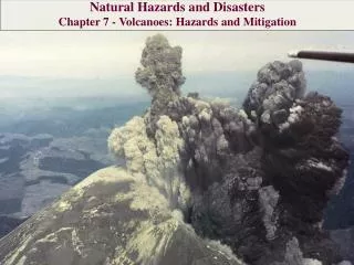
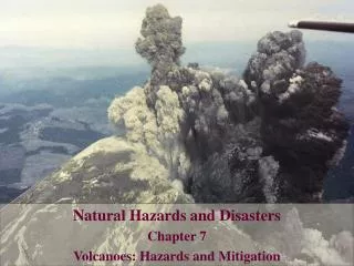
Identifying Natural Hazards Massachusetts State Hazard Mitigation Plan’s risk assessment, natural hazards have been grouped in the following categories: • Flood Related Hazards – heavy rain, dam failure, ice jams, coastal storms, and coastal erosion • Atmospheric Related Hazards – high winds, hurricanes, tornados, Nor’easters, and severe thunderstorms • Winter Related Hazards – heavy snow, ice storms, and blizzard • Geologic Hazards – earthquakes, landslides, and tsunami • Other Natural Hazards – wildfire, conflagrations (major urban fires), drought, and extreme temperatures
Flood Related Hazards • Inland or Riverine Flooding • Ice Jams • Coastal Storms
Inland or Riverine Flooding • Riverine or inland flooding can be caused by a number of factors, heavy rain, snowmelt, ice-jams, dam-breaks, and more. • Floods are among the most frequent and costly natural disasters • The annual rainfall approximately 48 inches. • 439 State owned structures in a SFHA.
The 100 Year Flood • The flood that has a 1% chance of occurring or being exceed in any given year. • A structure located within a Special Flood Hazard Area (SFHA) shown on an NFIP map has a 26 percent chance of suffering flood damage during the term of a 30-year mortgage. • FEMA produces Flood Insurance Rate Maps (FIRM’s) which depict SFHA, the areas subject to inundation from the 1% annual chance flood • 1978-2008 >26,000 claims totaling close to >$279,000,000
Ice Jams • A freeze up jam forms in the early winter as ice formation begins. This type of jam can act as a dam and begin to back up the flowing water behind it. • A break up jam forms as a result of the breakup of ice cover, causing large pieces of ice to move downstream potentially acting as a dam, impacting culverts and bridge abutments. • More than 200 reported ice jams in Massachusetts since 1910. • North Central Massachusetts, averages at least one ice jam per year.
Coastal Storms • Coastal storms are an intricate combination of events that impact a coastal area. • A coastal storm can occur any time of the year and at varying levels of severity. • Hurricane Bob and the 1991 October nor’easter caused $174 million in uninsured and NFIP claims.
Atmospheric Related Hazards • High winds • Hurricanes and tropical storms • Thunderstorms • Tornados • Nor'easters
Hurricanes and Tropical Storms • An intense tropical weather system with a well-defined surface circulation and a maximum sustained winds of 75-mph or higher. • Hurricane season from June 1 to November 30. • Between 1851 and 2004 42 storms have made landfall in MA. Massachusetts Hurricane and TS Landfalls
Thunderstorms • An atmospheric storm which can produce gusting winds, excessive rainfall amounts, hail, winds gusting, and/or tornados. • Average duration 30 minutes • Recent disaster activity, in 1998 a thunderstorm caused more than $7 million in damage (FEMA-1224-DR-MA). • The entire state of Massachusetts is susceptible to thunderstorms and severe storms.
Tornados • A violently rotating column of air that extends from the base of a thunderstorm to the ground. • Tornados are the most violent of all atmospheric storms. • Based on past events, the area at greatest risk for a tornado touchdown central to northeastern Massachusetts. • Most destructive tornado in New England history was the Worcester tornado of June 9, 1953, F-4
Nor’easter • Large counter-clockwise wind circulation around a low pressure center. • Damages flooding, wind damage, storm surge and erosion • Average frequency of 1 or 2 per year • Average duration can be from 12 hours to 3 days.
Winter Related Hazards • Heavy Snow • Ice storms • Blizzards Photo Credit: Martin Greene
Heavy Snow • Blowing Snow – Squalls Average annual Snowfall Blue Hills, MA 61.0 Inches Boston, MA 43.3 Inches Worcester, MA 69.1 Inches
Other Natural Hazards • Drought • Major Urban Fires • Wildfire • Extreme temperatures
Geologic Hazards • Earthquake • Landslide • Tsunamis
Earthquake • The last major earthquake to affect Massachusetts was more than 200 years ago in 1755 with an estimated magnitude of 6.0. The epicenter was located off the coast of Cape Ann, north of Boston.