Download

1 / 14
170 likes | 321 Views
Explore the synergy of Geographic Information Systems (GIS) and Building Information Modeling (BIM) across asset lifecycle phases for enhanced efficiency and cost-effectiveness. Learn how GIS enriches BIM processes, from planning to maintenance, with real-world spatial data integration.

E N D
So, what do we want integration, of- different disciplines (also GIS)- different phases of lifecycle assets
Design Preparation work Execution Maintenance Waarde Tijd Different phases • Ideal situation • Practice
What brings GIS for BIM processes authorization Traffic management Enforcement Asset management safety Acquisition Public space construction plan Development and implementation Cables & pipes visualisation Spatial planning Land development Programming Energy management Potential analysis Cultural heritage research Water management Soil management
3 Main lines • Geographical information for planning / preparation phase • Geographical information for asset management / maintenance • As-is (GIS) --> As-built (BIM) As-is (GIS)
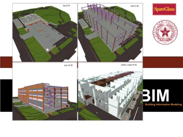
1. Geographical information for planning / preparation phase Like clash control in BIM
1. Geographical information for planning / preparation phase
2. Geographical information for asset management / maintenance Orientation of assets
2. Geographical information for asset management / maintenance Geographical objects as entry for the maintenance/assets attributes for asset planning
3. As-is (GIS) --> As-built (BIM) As-is (GIS) Efficient and cheaper maintenance of GI datasets As-is As-built
International standards • BIM B&U: IFC/bsDD • BIM Civil: LandXML • GIS: OGC / ISO/TC 211 • MoU: Building Smart and OGC • 34th ISO/TC 211 plenary meeting June 2012 Resolution 590: New ‘Ad hoc group’ “to investigate interoperability issues concerning the respective standards” − ISO TC 59 / SC 13 – “Organization of information about construction works” − ‘the ISO side of BuildingSMART’ − IFD, IDM, MVD − ISO/TC 211 “Geographic information/Geomatics” − ‘The ISO side of OGC’ − GML, CityGML