Download

1 / 31
310 likes | 335 Views
This guide offers insights into cross-country soaring flight planning, landing out strategies, landout locations, rubber band snapping, leaving the nest, challenges, and crucial forecasting tools like NAM and RASP Blipmaps. Learn techniques for ground base exercises, contingency planning, and optimizing your soaring experience. Enhance your skills and enjoy the freedom of cross-country gliding!

E N D
Cross country decisions, soaring forecast and flight planning from Byron RamyYanetz Jan 2016
It’s OK to land out! • From a recent article in soaring: “What I am about to say is probably the most important thing to new pilot who want to transition to XC: It’s OK to land out! Seriously – It’s almost one of the best parts of the sport!” • Willing and ready to accept the risk.
Three Simple Land out Plans • Plan A • Only consider landing at airfields you can aero tow from, then fly airport to airport • Plan B • Only consider airfields and known good strips and fields • Plan C • Rely on your abilities to pick a good field from the air in real-time, most advanced, more common in some places
The Landout - off airport • At 1000ft you should be at your LZ. • wind, slope, obstacles, backup plan determined • Fly around your field as you start your approach. View from all sides. • Look for poles, you likely won’t see power lines • Look for fences or lines of taller weeds, dirt built up • Slope? Land uphill. Favor uphill over into the wind in most cases. • Other risks? Squirrel holes, livestock, pipes, obstacles
Ground Base Exercise • Always be scouting landout locations • Driving along look at fields. • Could I land here? • How would I approach? • Slope? Prevailing winds? Obstacles
Byron landout options Aerotowable Tracy New Jerusalem Rio Vista Los Banos Hollister Livermore Concord Nut Tree Other good airports/strips Reid Hillview Meadowlark San Antonio Valley Santa Nella South County
Snapping the Rubber Band • Anxiety • It’s normal • Minimize, don’t try to eliminate • Skills • Weather and forecasting • Retrieve options
Challenges • Extremely brain intensive • High rate of decision making over long periods • Complex chess game • Requires thinking multiple moves in advance • Always having backup plans • Situational awareness and observation
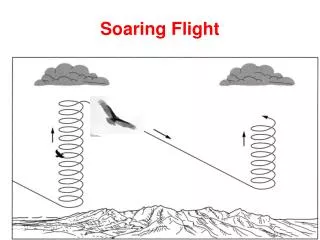
Leaving the nest • Head out a little bit. • Get a thermal, head a little farther, no thermal, come back. • If one path doesn’t work, try something different. • At some point, you will be unable to glide straight back to Byron. You’re now going XC. • Losing glide to Byron is snapping the rubber band. • There is a freedom that comes with being beyond glide of the home airport. Enjoy it. Settle into the rhythm.
Planning • Have routes in mind, scope them out • Weather - pick a good day, don't wait for epic • clouds? great! • lift to 7k in the mountains, 5k in the valley • light winds, decent convergence forecast • Peers - fly when others are flying • Coordinate retrieve buddies • Launch time? turn around time if coming back? • Goals? Minimums? Successful Outcomes?
Planning (continue) • Check the forecast carefully and frequently • NAM and RASP Blipmaps available up to 3 days • Don’t forget to check again in the morning before flight • Be ready early. Timing is everything. • Choose best route for the forecast • Look for unusual soaring conditions and landout options to plan new routes and unusual flights • Contingency planning, be flexible. • Be prepared for landout, carry spot/Inreach • Plan according to forecast, fly according to weather
Check forecast • NWS Forecast discussion • http://www.wrh.noaa.gov/mtr/forecast.php • Area forecast discussion (click on AFD) • Zone: East Bay Hills and Diablo Range • Check the 1km satellite image in the morning • NAM blipmap - most useful and reliable parameters: • BL Top • Cu Potential • Cu cloudbase • Total cloud cover • BL Wind • RASP most useful and reliable parameters: • Convergence • Average H-Crit/BLTop • Wave parameters (vertical velocity 850/700/500 and cross sections)
BlipMap NAM model • Available up to 3 days in advance • The most accurate model • Best for checking top of lift (BLTop), cu potential, cloudbase, wind and overcast up to 3 days in advance • Easiest map to read due to best color scale • Tendency to be overly optimistic in the longer term • If it indicates conditions which looks to good to be true, it probably is • If it indicates poor weather, it will most likely be true • Inaccurate for the valley, Unless it is a post frontal unstable day. • Map refreshes every 6 hours • last run is the 9hrs forecast
RASP Blipmaps • Available the prior evening and up to 2 days ahead • Much higher resolution: 3KM and 750m • Best for determining exact area of best lift, convergence (BL Max Up/Down) and wave • BLTop usually overly optimistic, so use Hcrit instead. Less reliable than NAM. • Clouds parameters are not as accurate as NAM. Cu potential is pessimistic while Cu base is optimistic and may indicate best case scenario. • Color contrast usually not as good as NAM • From the above reasons it is best to use RASP for location of lift and NAM for altitude
Forecast (Continues) • Often used but less useful parameters and common mistakes: • Thermal updraft velocity • NAM Cu Cloudbase for Cupot > 0 • B/S ratio • Using RASP instead of NAM • Fix color instead of classic color • Not looking at the whole picture
Byron Soaring Potential • In post frontal conditions (typically from Feb to May) the lift is accessible from local low tow and marked with 4000-6000ft cloud bases, providing XC routes to any direction • Great and consistent soaring conditions are only 20 miles away along the Diablo range convergence from March till October • Often marked with clouds over the San Antonio Valley, persists all day with typical altitude of 6000-8000, occasional 10,000 feet (highest 13,500!). • Easy glide back to Byron or Tracy from 6000 feet. • Often requires 20-25 miles 6000-7000ft tow to Rel1,2 when local lift not presents (20-30 min tow plane round trip)
Byron Soaring Potential • During spring time, The central valley provides safe and easy XC soaring, with plenty of airports and landout fields. • Even during the winter, it is possible to fly XC in post frontal conditions. • The Diablo Range to the south provides excellent convergence soaring year around. • Stable cool marine air is often found west of the convergence. Stable hot air east of the convergence over San Joaquin valley due to strong subsidence and inversion. Strong convergence in the middle over the Diablo ranges due to the different air masses.
Diablo Range/SAV Release Area If the lift near Byron does not go above 4000 feet, take a high tow (7000 feet) to the Diablo Range Tow towards Release 1 (Rel 1) at 70-75 knots so you will arrive there between 6-7000 feet Release (or stay on tow) and proceed towards Rel 2 along the spine until you find your first lift, usually near Rel2 If not proceed to Rel 3 and/or to Red Mountain on the edge of the San Antonio valley The lift is almost always in the area between Rel2,3, and Red Mountain. Follow the convergence line between red mountain, SAV and Mt Stake If no lift found head back to Byron before loosing glide (or Tracy if Byron is not in glide). San Antonio Valley has a good landing strip and good fields
Suggested Tasks from Byron • Silver Badge straight out: Byron to Hollister (100km) • Byron – Pacheco pass – Byron (yoyo): 100 miles • Straight Out to Avenal: 240km • Gold Badge: • Byron– San Benito Mtn (EL4) – Byron: 230 miles (300Km gold dist) • Diamond Badge: • Byron – Hwy41 (South of Avenal) – Byron: 324 miles (500km diamond dist) • Byron – New Cuyama – Byron: 450 Miles (700km) • Byron – Williams/Goat - Byron • Suggested Routes from Byron • North to Mt Diablo and across the delta to Williams only on unstable post frontal days, otherwise poor lift (less frequent) • Best and most common route south along the Diablo range • Often strong convergence marked with clouds over the highest terrain over SAV • When above 7K you can go in the middle, if lower move towards the east side. • When below 4000ft stick to the foothills and Hwy on the east side • Plenty of places to land on the east side, airstrips every 10-15 mls • Unless clouds indicate otherwise, stay towards the east side away from the sea breeze when crossing the Pacheco pass. • Avoid flying too far west or east of the convergence line
Byron Wave • Byron wave season Nov-April • Pre frontal wave is best during the hours before the onset of rain with increasing SW winds. • Pre Frontal Wave can be found anywhere between Byron and Los Vaqueros reservoir • Often marked with Lenticular clouds or fohen gaps • XC potential north to Williams and back • North wind wave usually during high pressure off shore wind events • Requires NNW-NE winds above 20 knots at Mt Diablo • Usually not marked by clouds • Wave typically weak (1-2 knots) and very small area (less than 1 square mile) near Wave1 (Diablo) and Wave3 (Los Vaqueros towers) • Typical altitude 12-18K • XC potential: North up wind to Napa and Clear Lake, south downwind to Big Sur and beyond
Convergence • Not a continuous line of lift • A line of occasional lift and often much stronger and higher reaching thermals • Follows ridgelines, pushes farther down valleys • Think of water flowing and being divided by ridges • Can be more turbulent. Mixed up, confused thermals • Half up/half down • Little to no wind on the ground • Often can be run along for miles without circling
Debriefing • Debrief every flight, even if it is just mentally • How would you have improved things? • Debrief Tools • OLC onlinecontest.org - web • See You,IGC Replay - PC • Performance parameters • average climb rate - higher is better • # thermals - lower is better • % circling - lower is better • effective L/D or efficiency - higher is better