Download
1 / 30
300 likes | 329 Views
Explore the potential of Byron for XC flights up to 500km, especially in spring and fall. Learn how to interpret blipmaps for accurate planning, assess convergence zones, and decide on launch timings. Discover key landing options for safe returns. References to NAM, RUC, and RASP models provided.

E N D
Safe XC Soaring from Byron Use of Blipmaps as an XC Planning Tool Ramy Yanetz February 2008
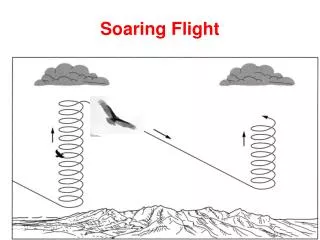
Byron XC Potential • 300-500km especially during the spring (March-June) and fall. • May require 20-30 miles 6000-7000ft tows when local lift not presents . • 25 miles tow @ 80knots = 30 minutes round trip ($82). • Often strong convergence marked with clouds over the Diablo Range between Mt Hamilton and Mt Oso, persists all day with typical altitude of 6000-8000, occasional 10,000 feet (highest 13,500!). • Easy glide back to Byron or Tracy.
2007 achievements • At least 7 pilots flew long XC flights from Byron • 7 flights north to Williams, 4 in one day! • Pasco Egg captured twice from Williams and twice from Hollister by NCSA pilots and flown back to Byron!
2007 Personal Statistics • 12 XC flights (averaging 250km per flight) • Longest flight 535km • Typical altitude 6000-9000 ft • 60% from local tows • 4 flights north across the delta
How to use blipmaps for XC planning • 3 blipmap models available – NAM (was ETA), RUC and RASP • Check NAM (ETA) forecast up to 3 days in advance. Typically optimistic in the longer range, more accurate the prior evening. • Look at the 1PM (21Z) forecasts. • Check the BLTop map (Height of Boundary Layer Top) – this is the most important and accurate parameter. It indicates how high you can get in the best thermals. • Check NAM Cumulus potential and Cumulus Cloudbase. Note cloudbase altitude is only valid if cumulus potential is positive. • On the prior evening check also RASP blipmap for higher resolution. • On the morning of the flight check also RUC. If it strongly disagree with the other models, good old RUC is probably right. If all 3 models predicting a great day – go fly!.
How to use blipmaps for XC planning (continue) • Determine best XC route for the day. • If NAM predicts little or no clouds, but shows BLTop of at least 6000ft over the Diablo range, then plan on a long tow to the Diablo range and release near Rel1-3 above 6000ft, and follow the convergence line to the SE • If NAM predicts good cu’s (cu potential > 0) and cloud base of at least 4000ft all the way across the delta then plan to fly north towards Williams • Detrermine best time to launch. Typically no later than noon, and as early as 10AM if the 10AM RASP indicates good lift.
NAM Blipmap • http://www.drjack.info/BLIP/ETA/CANV/ • Available up to 3 days in advance • Tendency to be overly optimistic • The shorter the term the more accurate • Best for checking BLTop, cu potential, cloudbase, wind up to 3 days in advance • Easy map to read, best color scale
RASP Blipmaps • http://www.norcalsoaring.org/BLIP/BYRON/index.html • Kudos to Dmitry for creating the Byron RASP blipmap! • Available the prior evening and now up to 2 days ahead • Much higher resolution: 3KM and 750m • Can flip between map and sectional for orientation • For top of lift us Hcrit, not BLTop (overly optimistic) • Check wind direction and strength, cloud potential, cloud base, convergence (BL Max Up/Down) and wave parameters • Easier to determine exact area of best lift, convergence and wave, but harder to determine exact altitude due to color scale • Use RASP to determine location and NAM to determine BLTop and cloudbase • Pay special attention to the area of best lift (usually along the Diablo range south of Byron) to plan the best XC route.
RUC Blipmap • http://www.drjack.info/BLIP/RUC/CANV/ • Available only in the morning • RUC BLTop Provides the most accurate and reliable top of lift. It is usually accurate within couple of hundred feet (especially the 6 hour forecast, which is usually available after 9:30AM). • Rest of the parameters, especially cloud base, are not as accurate as NAM
Preparation • Check Blipmap and other forecast tools such as the NOAA weather discussion • Determine XC potential and route • Download latest waypoints for Byron/Hollister area and Williams area http://soaring.gahsys.com/TP/Hollister/http://soaring.gahsys.com/TP/Williams/ • Study routes using google earth http://soaring.gahsys.com/TP/Hollister/hollstr7.kmz • Study landouts http://www.soaringnet.com/landout_data/hollister/ • Download IGC files from OLC and study with SeeYou
Suggested Routes • North across the delta on unstable post frontal days • South along the Diablo range on most spring days
Landout options (South) • Livermore (Tower, OK if can’t make it back to Byron) • Meadowlark • San Antonio Valley (in the Diablo Range) - Landing strip and good fields • Tracy • New Jerusalem • Westley (marginal, probably not aero retrievable) • Patterson • Crows Landing (Huge, but access unknown) • Gustine • Los Banos • Panoche
North across the Delta • When blipmap indicates good post frontal conditions with cu’s across the delta, a safe and relatively easy task will be a 300km O&R to Williams (with optional landing at Williams to capture the Pasco egg) • No high terrain and tiger country to deal with and plenty of landing strips • Unless clouds indicate otherwise, fly towards Rio Vista first • Typically less or no clouds for 10-20 miles across the delta until Rio Vista so start as high as possible, at least 4000 ft and with glide to Rio Vista.
North across the delta (continue) • From Rio Vista head towards the Nut Tree • Avoid Travis airspace, watch for heavy traffic, keep your transponder on and contact Travis as needed • From Rio Vista follow the mountains or foothills towards Williams. • Usually better and stronger lift over the mountains, but no need to go too deep and the valley works as well
Crossing the delta back to Byron • On the way back the first area to shut down is the delta, so don’t turn around too late • Typically no lift and often no clouds from Nut Tree area to Rio Vista area • Unless clouds indicate otherwise, or you are very high over the Nut Tree for a final glide to Byron (above 7000ft) do not attempt a straight glide across, as you will most likely encounter stable marine air and strong cross wind • Instead, head towards Rio Vista even if there are no more clouds, and hope for the best. Often the lift starts again near Rio Vista which takes you high enough for a final glide to Byron.
Airports Landouts (North) • Rio Vista • Nut Tree • Multiple strips between Vacaville and Williams
Suggestions • XC Mentoring in KP or buddy flying in single seaters • Get your silver and gold distance from Byron during spring • Capture the pasco egg from Williams or Hollister