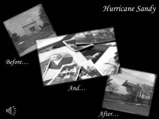
Tracking Hurricane Sandy
Join us as we explore Hurricane Sandy's impact, characteristics, and lessons learned, presented during the California Science Conference on October 26, 2013. Hosted by the Satellite Educators Association, this comprehensive session uses satellite images and analysis techniques like ImageJ and GIS to observe weather patterns, analyze storm characteristics, and differentiate between wind speed and storm speed. Engage with expert groups in a collaborative learning environment to understand severe storm action and apply knowledge to other natural disasters.

Tracking Hurricane Sandy
E N D
Presentation Transcript
Tracking Hurricane Sandy Pete Arvedson California Science Conference October 26, 2013 Hosted by Satellite Educators Association
View these video clips: 0508.katrina.mov 121020-31_sandy_life.mov Satellite Educators Association
What did you see? Satellite Educators Association
What would you like to know more about? Satellite Educators Association
Lesson Objectives Observe severe storm action from space ID weather patterns Differentiate wind speed from storm speed Analyze satellite images of storms – ImageJ Analyze storm characteristics – GIS Apply skills to analysis of other storms Satellite Educators Association
Tropical Cyclones • Not like frontal storms • Cyclonic • Require… • Warm ocean water… • At least 26.5˚C (79.7˚F) • To depth at least 50m (164ft) • Slowly rising air Satellite Educators Association
Tropical Cyclones HURRICANE HURRICANE TYPHOON CYCLONE Satellite Educators Association
http://indigenouscaribbean.ning.com/group/archaeologyofthecircumcaribbean/forum/topics/the-ceremonial-taino-petaloidhttp://indigenouscaribbean.ning.com/group/archaeologyofthecircumcaribbean/forum/topics/the-ceremonial-taino-petaloid Huracán • Taino people • Puerto Rico • Thunder and deluge caused by matriarch’s male attendants • Columbus lost ships to huracán • Notice Taino symbol for storm Satellite Educators Association
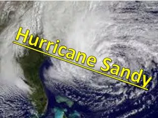
Hurricane • Slowly rising • Warm • Moistened • Air • Circles • Drawing more energy from warmer-than-usual water http://visibleearth.nasa.gov Satellite Educators Association
Hurricane http://www.nasa.gov/mission_pages/hurricanes/archives/2012/h2012_Sandy.html Horizontal bands of rain form arms of spiral Satellite Educators Association
Hurricane Eye http://earthobservatory.nasa.gov/Features/Hurricanes/hurricanes_2.php • Cooler air drawn down thru center • Relatively calm clean air • Eyewall – most destructive • Wind direction same as storm’s forward motion Satellite Educators Association
Saffir-Simpson Scale for Hurricanes Satellite Educators Association
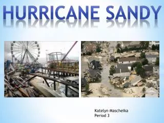
Billion Dollar Storms • Chris Dolce – The Weather Channel… • 1900-early August 2011 27 “billion dollar storms” • 8 of the “top ten” occurred since 2004 • 7 surpassed $10 billion mark.. • 6 of those 7 occurred since 2004 • 3 rank in $10-$20 billion range… • Ivan & Charley (2004) & Rita (2005) • 3 rank in $20-$30 billion club • Andrew (1992), Wilma (2005), Ike (2008) • 1 at $108 billion damage – Katrina (2005) • Hurricane Sandy – 2nd place at $65 billion in damage Satellite Educators Association
Jigsaw Expert Groups • Data Miners • NHC Advisory Archive data to csv • Cartographers • Display/manipulate csv data in GIS • Meteorologists • Research Hurricane Sandy characteristics and behavior online • Analysts • Measure Hurricanes Sandy & Katrina with ImageJ Satellite Educators Association
Expert 1: Data Miners National Hurricane Center Past Advisory Archive http://www.nhc.noaa.gov Satellite Educators Association
Expert 2: Catographers ESRI’s ArcGIS Explorer Online http://bit.ly/1tkevgO Satellite Educators Association
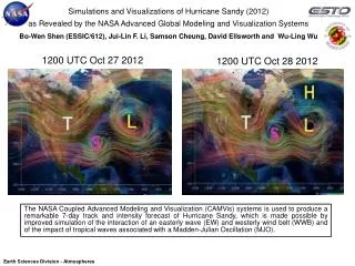
Expert 3: Meteorologists Hurricane Sandy research using NASA hurricane archives http://www.nasa.gov/mission_pages/hurricanes/archives/2012/h2012_Sandy.html Satellite Educators Association
Expert 4: Analysts • Measure cloud fields of Hurricanes Katrina & Sandyusing ImageJ… • Diameter • Perimeter • Area Satellite Educators Association
Sandy vs. Katrina Satellite Educators Association
Home Teams • Expert reports • Compare… • Hurricane Sandy • Hurricane Katrina • Using ArcGIS Explorer Online http://bit.ly/1tkevgO Satellite Educators Association
Extend Use suggestions from printed lesson plan Note learners’ questions during the lesson and encourage learners to devise a plan for and follow through an investigation of one or more of those questions. Satellite Educators Association
National Science Education Standards • Grades K-4: • Physical Science – Position & Motion of Object • Earth & Space Science – Changes in Earth and Sky • Grades 5-8: • Science as Inquiry • Abilities necessary to do scientific inquiry • Understandings about scientific inquiry • Physical Science – Motion and Forces • Earth & Space Science – Structure of the Earth System • Science in Personal & Social Perspectives • Grades 9-12: • Science as Inquiry • Abilities necessary to do scientific inquiry • Understandings about scientific inquiry • Science in Personal & Social Perspectives Satellite Educators Association
Next Generation Science Standards • Grade 4: Earth & Space Science • Natural Hazards –- 4-ESS3-2 • Grade 5: Earth’s Systems • Earth Materials and Systems -- 5-ESS2-1 • Grades 6-8: Earth’s Systems • The Roles of Water in Earth’s Surface Processes – MS-ESS2-5 • Weather and Climate –- MS-ESS2-6 • Natural Hazards – MS-ESS3-2 • Grades 9-12: Earth’s Systems • The Roles of Water in Earth’s Surface Processes – HS-ESS2-5 • Weather and Climate – HS-ESS2-4 • Grades 9-12: Earth and Human Activity • Natural Hazards – HS-ESS3-1 Satellite Educators Association
Contact Information Satellite Educators Association… http://SatEd.org Pete Arvedson… SEA.Research@SatEd.org SEA Newsletter (online)… http://SatEd.org SEA Lesson Plan Library (free online)…http://SatEd.org/library/ SEA’s M.Y. S.P.A.C.E.* Program - K-12 international environmental research collaborative program using satellite-based data… http://SatEd.org/MYSPACE/ *(Multinational Youth Studying Practical Applications of Climatic Events) Satellite Educators Association