Download
1 / 17
170 likes | 190 Views
This international conference explores the current and future state of water resource management and environmental issues in Central Asia, with a focus on the impacts of climate change on the Kunduz and Panjshir River Basins in Afghanistan. The conference will discuss research findings, conclusions, and recommendations for climate change mitigation and adaptation in the region.

E N D
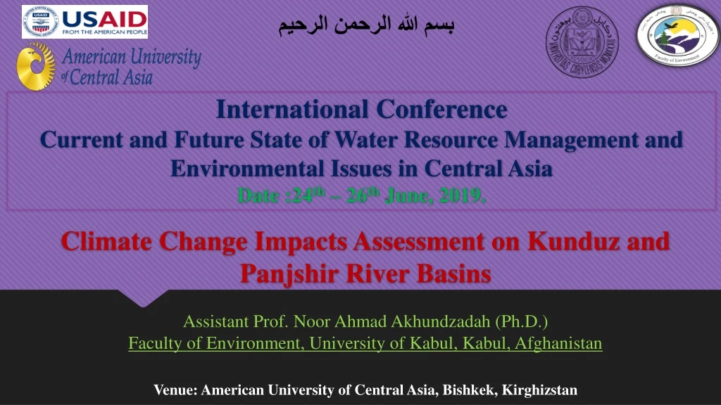
بسم الله الرحمن الرحيم International ConferenceCurrent and Future State of Water Resource Management and Environmental Issues in Central AsiaDate :24th – 26th June, 2019. Climate Change Impacts Assessment on Kunduz and Panjshir River Basins Assistant Prof. Noor Ahmad Akhundzadah (Ph.D.) Faculty of Environment, University of Kabul, Kabul, Afghanistan Venue: American University of Central Asia, Bishkek, Kirghizstan
Climate Change Impacts Assessment on Kunduz and Panjshir River Basins Contents • Introduction and Study Area • Study Area Climate, Hydrology and Geology • Research Methodology • Results (Change in Air Temperature, Precipitation, River Discharge and Change in Landcover) • Conclusions and Recommendations • References
Climate Change Impacts Assessment on Kunduz and Panjshir River Basins Introduction • Afghanistan Main River Basinsand Water Resources Potential. • The Rivers Basins are the main water resources used for drinking, irrigation, hydropower and environmental purposes. • All the five River Basin are deeply affected by Climate Change (Aichte al, 2017) • About80% of the population depends on agriculture for their livelihoods and half of the GDP (World Bank, 2004).
Climate Change Impacts Assessment on Kunduz and Panjshir River Basins Study Area Location and Topography
Climate Change Impacts Assessment on Kunduz and Panjshir River Basins Climate Precipitation and Temperature Figure: Present map of the weather measurement points within the study area.
Climate Change Impacts Assessment on Kunduz and Panjshir River Basins Climate Precipitation (2019)
Climate Change Impacts Assessment on Kunduz and Panjshir River Basins Hydrology Long-term average discharge at Kunduz River Basin (1960 – 1980) Long-term average discharge of PanjshirRiver (1960-1980) Figure: Map present main tributaries and stream gauges’ location within the watersheds.
Climate Change Impacts Assessment on Kunduz and Panjshir River Basins Geology • The Panjshir River Basin is bounded by high Hindukush mountain ranges. Topography of the River Basin is strongly influenced by regional and local tectonic activity and by fluvial processes in the valley basin. • The basin is Active stream channels are generally narrow and shallow flowing in the basins throughout the whole year. • In the Southern part the Kunduz River Basin the Hindukush Mountains mostly consisted Paleogene and Neogene sediments. • The central area of the Basin along the River covered by Loess deposits (30m to 100m thickness) it covers wide floodplains area. Figure: Geological map of the study area with geological faults.
Climate Change Impacts Assessment on Kunduz and Panjshir River Basins Research Methodology • Analyzing existing Hydrometeorological data using M.S. Excel. • There is about 20 years data gaps during war period (1980-2001). • Current Meteorological data is provided by WorldWeatherOnline.com (2009-2018). • For landcover estimation ArcGIS and Manifold GIS package are used. • Stellate Images of different online sources were used for landcover. Research Objective To assess climate change impacts on surface water resources, change in warming, precipitation and landcover with the Kunduz and PanjshirRiver Basins. For climate change impacts assessment existing historical hydrometeorological data is used to investigate climate change impacts on both River Basin and find out the long-term change in surface water, temperature rise, and landcover change.
Climate Change Impacts Assessment on Kunduz and Panjshir River Basins Results and Discussions • Climate Change impacts gradually increased mean annual temperature inversely it decrease precipitation, River discharge and change landcover of both River Basin. Change in mean annual temperature and precipitation Figure: Study Map. study area.
Climate Change Impacts Assessment on Kunduz and Panjshir River Basins Results and Discussions Change in River Discharge
Climate Change Impacts Assessment on Kunduz and Panjshir River Basins Change in Landcover
Climate Change Impacts Assessment on Kunduz and Panjshir River Basins Change in Landcover (FAO, 2016) Panjshir River Watershed Kunduz River Watershed
Conclusions and Recommendation • Results • Climate Change impacts increase air temperature and wind storms. • It gradually decreased precipitations and surface water. • It changed landcover of the area. • There is big potential for Climate Change Mitigation and Adaptation within the River Basins. • Recommendations • Climate Change Mitigation and Adaptation through Community Based NRM within the watershed. • IWRM and CCMA implementation is highly required for River Basin Water Resources Conservation and Management. • Disaster Management through Ecosystem based approaches. • Sustainable energy extension and use (Developing hydropower, solar, biomass, hydrothermal, wind energy resources ant not fossil fuel energy use). • Joint work of the Amu River Basin countries on.
Conclusions and Recommendation • Challenges • Luck of exact long-term Hydrometeorological data. • Luck of precis Remote-sensing and online data. • Luck of high level Remote-sensing technology and professional level ArcGIS analyzing techniques and trainings. • Need Hydrometeorological, Hydrogeological, Natural Disaster data of the Transboundary Basin countries data. • Regional cooperation and budjet.
References • Afghanistan Intended Nationally Determined Contribution (INDC), 2015, Submitted to the United Nations Framework Convention on Climate Change (UNFCCC). • Aich, V., N.A. Akhundzadah, A. Knuerr, A.J. Khoshbeen, F. Hattermann, H. Paeth, A. Scanlon and E.N. Paton., 2017, Climate Change in Afghanistan Deduced from Reanalysis and Coordinated Regional Climate Downscaling Experiment (CORDEX) South Asia Simulations. Journal Climate, 5, 35. Online (www.mdpi.com/journal/climate). • Central Statistical Organization (CSO) Afghanistan, Statistical Yearbook 2015-2016; 2016. • Environment and Security in the Amu Darya Basin., 2011, Prepared in corporation with UNEP, UNDP, UNECE, OSCE, REC, NATO. • Favre, Raphy and G. M. Kamal. 2004. Watershed Atlas of Afghanistan. Helolse Condroyer, Atlas Communication, 2004. • FAO, 1993, The Islamic Republic of Afghanistan Watershed Atlas, Food and Agriculture Organization of the United Nations (FAO) Rome, Italy. • Habib, H., Anceno, A. J., Fiddes, J., Beekma, J., Ilyuschenko, M., Nitivattananon, V., & Shipin, O. V. 2013. Jumpstarting post-conflict strategic water resources protection from a changing global perspective: Gaps and prospects in Afghanistan. Journal of Environmental Management, 129, 244–259. 10.1016/j.jenvman.2013.07.019 • Lashkaripour, G. R., & S.a. Hussaini, 2007, Water resource management in Kabul river basin, eastern Afghanistan. The Environmentalist, 28(3), 253–260. http://doi.org/10.1007/s10669-007-9136-2. • Mack, T.J., M.A. Akbari, M.H. Ashoor, M.P. Chornack, T.B. Coplen, D.G. Emerson, B.E. Hubbard, D.W. Litke, R.L. Michel, L.N. Plummer, M.T. Rezai, G.B. Senay, J.P. Verdin, and I.M. Verstraeten, 2010, Conceptual model of water resources in the Kabul Basin, Afghanistan: U.S. Geological Survey Scientific Investigations Report 2009–5262. • Ministry of Energy and Water., 2016, Hydrological Year Book., Kabul, Islamic Republic of Afghanistan. • World Bank, 2004, Water Resource Development in Northern Afghanistan and its Implications for Amu Darya Basin, World Bank Working Paper No. 36. Washington, D.C. 20433, U.S.A.
له توجه نه مو مننه از توجه تان تشکرمننه Thanks for Attention