Download
1 / 5
50 likes | 189 Views
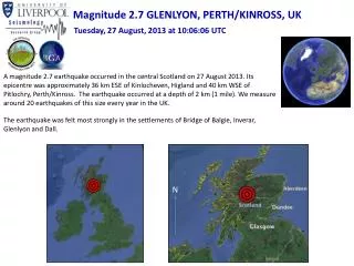
Magnitude 2.7 GLENLYON, PERTH/KINROSS, UK. Tuesday, 27 August, 2013 at 10:06:06 UTC.

E N D
Magnitude 2.7 GLENLYON, PERTH/KINROSS, UK Tuesday, 27 August, 2013 at 10:06:06 UTC A magnitude 2.7 earthquake occurred in the central Scotland on 27 August 2013. Its epicentre was approximately 36 km ESE of Kinlocheven, Higland and 40 km WSE of Pitlochry, Perth/Kinross. The earthquake occurred at a depth of 2 km (1 mile). We measure around 20 earthquakes of this size every year in the UK. The earthquake was felt most strongly in the settlements of Bridge of Balgie, Inverar, Glenlyon and Dall. N
Magnitude 2.7 GLENLYON, PERTH/KINROSS, UK Tuesday, 27 August, 2013 at 10:06:06 UTC Where was it felt? Maximum recorded intensity ofII (slight shaking) in surrounding settlements of Bridge of Balgie, Inverar, Glenlyon and Dall. 10 km Modified Mercalli Intensity Scale
Magnitude 2.7 GLENLYON, PERTH/KINROSS, UK Tuesday, 27 August, 2013 at 10:06:06 UTC Earthquake and historic seismicity The earthquake epicentre (red star) is plotted on the map with regional historic seismicity. Small earthquakes in this region of the UK are not unusual. Historic recorded seismicity of the British Isles Historic seismicity in the region of the mainshock (image courtesy of BGS)
Magnitude 2.7 GLENLYON, PERTH/KINROSS, UK Tuesday, 27 August, 2013 at 10:06:06 UTC Tectonic interpretation Although the UK does not lie on an active tectonic plate boundary (one of its nearest plate boundaries being the Mid-Atlantic Ridge – located some 2000 km to the west), stress within the plate is released along pre-existing faults within the crust. Some of these ancient faults are generally not exposed at the surface (these are known as ‘blind faults’) and in areas of low seismicity, such as the British Isles, it is difficult to identify the causative fault. Furthermore, with such low magnitude events, it is not possible to determine the earthquake’s precise mechanism. Alpine – Pyrenees mountain belt Mid-Atlantic Ridge Africa – Eurasia collision zone Map of major tectonic boundaries in Western Europe
Magnitude 2.7 GLENLYON, PERTH/KINROSS, UK Tuesday, 27 August, 2013 at 10:06:06 UTC Find out more… • BGS (British Geological Survey) – seismology and earthquakes – frequently asked questions http://www.earthquakes.bgs.ac.uk/education/faqs/faq_index.html • IRIS (Incorporated Research Institutions for Seismology) – learning about earthquakes http://www.iris.edu/hq/programs/education_and_outreach/students • UK School Seismology Project – classroom activities, videos and support documents http://www.bgs.ac.uk/schoolseismology/home.html • USGS (United States Geological Survey) – FAQs, glossary, posters, animations http://earthquake.usgs.gov/learn/ • EMSC (European Mediterranean Seismological Centre) http://www.emsc-csem.org/