Context for Semantic Interoperability: GALEON, OPeNDAP, WCS, etc
360 likes | 545 Views
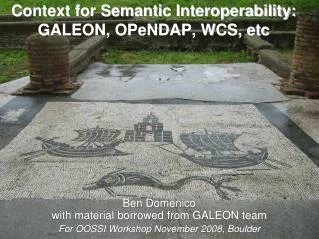
Context for Semantic Interoperability: GALEON, OPeNDAP, WCS, etc. Ben Domenico with material borrowed from GALEON team For OOSSI Workshop November 2008, Boulder. Our Work Together is a Mosaic. Ostia Antica circa 7 BC. Context for Semantic Interoperability: GALEON, OPeNDAP, WCS, etc.

Context for Semantic Interoperability: GALEON, OPeNDAP, WCS, etc
E N D
Presentation Transcript
Context for Semantic Interoperability:GALEON, OPeNDAP, WCS, etc Ben Domenico with material borrowed from GALEON team For OOSSI Workshop November 2008, Boulder
Our Work Together is a Mosaic Ostia Antica circa 7 BC
Context for Semantic Interoperability:GALEON, OPeNDAP, WCS, etc • Focus on an atmospheric use case • Data types should generalized to marine and related sciences • Context includes: • data discovery • data Access • location semantics • Does NOT include disciplinary semantics
A Basic Standards Use Case forAtmospheric Data Types Compare model output and observation data near airport Specify 3D bounding box centered on airport Specify time frame of interest (e.g., periods of severe storms) Request observed and forecast atmospheric parameter values In GALEON 1, WCS worked well for gridded data from forecast model output and some satellite imagery
Airport Weather Use Case:Examples of Unidata “Common Data Model” Scientific Data Types and Climate Science Modelling Language Scientific Feature Types point data from lightning strike observations "station" observations from fixed weather stations vertical profiles from balloon soundings and wind profilers trajectory data obtained from instruments onboard aircraft which have taken off and landed recently volumetric scans from ground-based radars visible, infrared, and water-vapor (and possibly other wavelength) satellite imagery gridded output from national or hemispheric weather forecasts (typically run at centers like NCEP and ECMWF) -- sometimes used as boundary conditions for a higher-resolution local forecast model.
Special Requirements • Real-time access • Elevation/altitude dimension is important • Elevation dimension often given in terms of pressure • Range value interpolation depends on physics (and data) as well as geometry • Automated processing components, e.g., • Gridding/assimilation • Forecast models • Transformations between pressure and height
FES Client Applications GIS Client Applications FES Servers GIS Servers THREDDS Server GIS Server THREDDS Server OGC or THREDDS, OPeNDAP, ADDE. FTP… protocols OpenGIS Protocols: WMS, WFS, WCS, CSW Satellite, radar, forecast model output, … datasets OGC or proprietary GISprotocols GIS Server Hydrologic, demographic, infrastructure, societal impacts, … datasets Taking Advantage of Web Services for Data System Interoperability
Status in FES Realm Unidata IDD delivers many GB/hr of real-time data OPeNDAP delivers many dataset types, but it operates in index space rather than coordinate space ADDE (Abstract Data Distribution Environment from McIDAS package) has value at the CDM Scientific Data Type level, but is not widely adopted THREDDS provides catalog data framework for its own community THREDDS Data Server integrates services CF conventions: available for gridded data, coordinate system specs are more explicit now proposed for point, station, trajectory -- including means for specifying locations for non-gridded data collections.
WCS capabilities WCS description THREDDS interface THREDDS interface WCS Client NcMLGML getCapabilities getCoverage geoTIFF netCDF describeCoverage WCS coverage GMLgenerator NetCDF geoTIFFgenerator NcML-G metadata THREDDS catalogs ADDE OPeNDAP THREDDS catalogs enhanced with NcML-GML NetCDF/OPeNDAP data server netCDF objects OPeNDAP ADDE NetCDF dataset THREDDS enhanced catalog generation tools …
Salient GALEON Lessons Relatively simple WCS use case is valuable: Bounding box, time frame, coverage name (e.g., surface temperature) subsetting is practical CF-netCDF payload works for many clients WCS limitations: gridded data (regularly spaced in some projection WCS 1.1 complicated (all things to all people) Proposed core and extensions approach value not clear yet
Appropriate Standards for Non-gridded or Irregularly-gridded Datasets? Apply to Collections of: lightning strike point observations, weather station observations, vertical profiles, onboard aircraft observation trajectories, volumetric radar scans, satellite swath images Fit with Sensor Web Enablement (SWE) Observations and Measurements (O&M)? Relationship to ISO 19123 coverage specification? Delivery via WCS, WFS, SOS? Coordinate Reference System for collections Web Processing Services (WPS and WCPS) GML role: CSML, NcML-GML, GML-JP2K? CS-W cataloging
ProfileFeature RaggedSectionFeature Climate Science Modelling Language Scientific Feature Types ScanningRadarFeature GridFeature ProfileSeriesFeature Thanks to Andrew Woolf of BADC
CSML Feature Type CDM Feature Type PointFeature PointFeature CSML-CDM Mapping PointSeriesFeature StationFeature TrajectoryFeature TrajectoryFeature PointCollectionFeature PointFeature collection at fixed time ProfileFeature ProfileFeature ProfileSeriesFeature StationProfileFeature at one location and fixed vertical levels RaggedProfileSeriesFeature StationProfileFeature at one location SectionFeature SectionFeature with fixed number of vertical levels RaggedSectionFeature SectionFeature
WCS and SWE O&M Feature of Interest – bounding box and time frame in WCS Sampling Feature (FES data sets are discrete samples of continuously varying properties of the feature of interest) Collections of Sampling Features as“Sampling Coverages”? Observations and Measurements Documents (up for revision)http://www.opengeospatial.org/standards/om
ISO Coverage Definition:Background Information • A coverage is a feature that associates positions within a bounded space (its domain) to feature attribute values (its range). In other words, it is both a feature and a function. • Examples include a raster image, a polygon overlay or a digital elevation matrix. • A coverage may represent a single feature or a set of features • A coverage domain is a set of geometric objects described in terms of direct positions. • The direct positions are associated with a spatial or temporal coordinate reference system. • Commonly used domains include point sets, grids, collections of closed rectangles, and other collections of geometric objects.
Coverage Range Characteristics • The range of a coverage is a set of feature attribute values. • Coverages often model many associated functions sharing the same domain. • EXAMPLE A coverage might assign to each direct position in a county the temperature, pressure, humidity, and wind velocity at noon, today, at that point. The coverage maps every direct position in the county to a record of four fields.
ISO 19123 Coverages • Up for revision • In most cases, a continuous coverage is also associated with a discrete coverage that provides a set of control values to be used as a basis for evaluating the continuous coverage. • Evaluation of the continuous coverage at other direct positions is done by interpolating between the geometry value pairs of the control set (thiessen polygon, quadrilateral grid, hexagonal grid, TIN, segmented curve)* l • Discrete coverage types can represent sampling features of O&M • Collections of sampling features as sampling coverages* *Possible candidates for revision that’s underway
Scientific Data Types Mapping to ISO Coverages *Generally, the domain is a set of irregularly distributed points
Data Access: WCS, WFS, SOS WCS makes sense for grids and images Coverages are a special type of feature CSML defines Scientific Feature Types WFS delivers coverages? WCS for grids; WFS for non-gridded collections? WCS / SOS relationship Efforts at Washington U in St. Louis Oceans I. E. 2 Topic? SOS feeds observations into WCS? SOS serves observation data from WCS?
GIS Clients WCS Clients Data Types and Service Protocols OGC Protocols WebCoverageService Sensor Observation Service Web Feature Service GALEON FES Data Collections on Server(s) WCS:Regularly Spaced Grids Point data Vertical Soundings Trajectories Radar Volume Scans Satellite Images Forecast Model Output Grids
GIS Clients SOS Clients WCS Clients Data Types and Service Protocols OGC Protocols WebCoverageService Sensor Observation Service Web Feature Service GALEON Oceans I.E. FES Data Collections on Server(s) WCS:Regularly Spaced Grids Point data Vertical Soundings Trajectories Radar Volume Scans Satellite Images Forecast Model Output Grids
ISO 19111 Coordinate Systems Earth referenced coordinate reference system (CRS) Engineering coordinate system (with point in Earth-referenced CRS as origin Image coordinate system ISO Document: Geographic Information: Spatial Referencing by Coordinates
Engineering Coordinate Systems Not directly Earth referenced Most remote sensing systems Examples: Wind profiler Surface radar scanning Satellite scanning algorithms Aircraft-borne radar
Data point locations Explicit with each data point, e.g., lightning Tabular, e.g., repeated observations at fixed* station locations(*Note that station locations may change, but not often compared to data value changes) Fixed algorithmic grid, e.g., output of forecast models Moving platform - explicit locations, e.g. aircraft-borne observations along flight paths (trajectories) Moving platform – algorithmic location, e.g., satellite position given by orbital mechanics
Earth Coordinate System Basics Coordinates relative to mean sea level (MSL) ellipsoid or geoid (gravity irregularities) 2D position on surface geographic (latitude, longitude) or projected (onto x, y coordinates) Elevation relative spatial elevation relative to MSL elevation relative to actual surface of Earth(digital elevation model relative to MSL) data dependent proxy (e.g., air pressure,data-dependent physics, e.g., hydrostatic equation, relative to MSL)
Compound CRS(Ben’s simplified version to illustrate atmospheric data use cases) *Moving observation platform.
GML OGC Document Core plus extensions approach Related to GALEON WCS manifest CSML NcML-GML GML-JP2K
Web Processing Services • Interpolating gridded data to points • Assimilating observed data samples to grid • Converting from pressure to height and back • Most transformations depend on physics (and data as well) • WCPS available as well as WPS • References?
CS-W Cataloging CS-W Specification Gi-GO Client ESRI Client GMU CS-W service for THREDDS Data Server
CS/W-THREDDS Gateway OGC Clients Search/Browse Data Access CS/W Interface TDS WCS Interface CS/W Server THREDDS Data Server THREDDS to CSW Metadata Mapping CS/W Database Ingestor On-Demand and Scheduled Pulling TDS Catalog Interface
Action Plan Outline • Agree on high-level dataset categories • Clarify relationships among: • Unidata CDM Scientific Data Types • CSML Scientific Feature Types • Obs. & Meas. Sampling Features • Establish extensions to CF conventions for each dataset category • Map CF-netCDF categories to ISO 19123 • Establish metadata forms: CSML, ncML-G • Experiment with CF-netCDF encoded coverages as payload for WCS, WFS, SOS
Divide (Labor) and Conquer • Coordinate individual efforts toward a whole greater than the sum of the parts • Each group focuses on areas of expertise • Work on tasks group has funding for • Stay aware of other groups’ efforts • Coordinate efforts wherever possible • Results of lessons learned from implementation and experimentation feeds into standard definition process
Future Directions CF conventions for non-gridded CDM data types -- including explicit Coordinate Reference System (CRS) information Mappings CDM data types to ISO 19123 coverage data model CDM data types to CSML scientific feature types CDM data types to SWE O&M sampling feature types CF-netCDF coverage encoding spec for all Unidata Common Data Model data types Figure out delivery protocol later (WCS, WFS, SOS?
References • GALEON Wiki • Unidata NetCDF • CF Conventions • OGC WCS Specification • OGC Observations and Measurements: • ISO 19123 Coverage Specification • GML • CSML • NcML-GML • ISO 19111: Geographic Information: Spatial Referencing by Coordinates • CS-W • Interoperability Day Presentations • Andrew Woolf • Stefano Nativi • Wenli Yang • Stefan Falke • ESIN Paper • Proposed CF conventions for non-gridded datasets • HTML version of this presentation