Within 200 m. from Chehalis River
10 likes | 151 Views
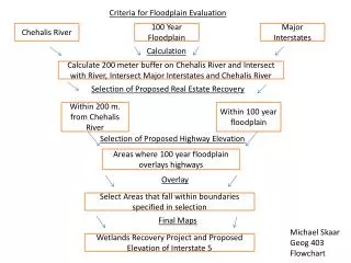
Criteria for Floodplain Evaluation. Chehalis River. 100 Year Floodplain. Major Interstates. Calculation. Calculate 200 meter buffer on Chehalis River and Intersect with River, Intersect Major Interstates and Chehalis River. Selection of Proposed Real Estate Recovery.

Within 200 m. from Chehalis River
E N D
Presentation Transcript
Criteria for Floodplain Evaluation Chehalis River 100 Year Floodplain Major Interstates Calculation Calculate 200 meter buffer on Chehalis River and Intersect with River, Intersect Major Interstates and Chehalis River Selection of Proposed Real Estate Recovery Within 200 m. from Chehalis River Within 100 year floodplain Selection of Proposed Highway Elevation Areas where 100 year floodplain overlays highways Overlay Select Areas that fall within boundaries specified in selection Final Maps Michael Skaar Geog 403 Flowchart Wetlands Recovery Project and Proposed Elevation of Interstate 5