Download
1 / 24
240 likes | 438 Views
Chehalis River Basin Flood Entity Formation Public Meeting Centralia Middle School, Centralia – October 28, 2010. Meeting Goals. Present information and answer questions on forming a multi-county flood district in the Chehalis River Basin Outline formation process and schedule

E N D
Chehalis River Basin Flood Entity Formation Public Meeting Centralia Middle School, Centralia – October 28, 2010
Meeting Goals • Present information and answer questions on forming a multi-county flood district in the Chehalis River Basin • Outline formation process and schedule • Discuss next steps • Receive your input on formation process
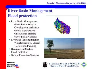
The Issues • Repeated major flooding in the Chehalis Basin including Lewis, Thurston and Grays Harbor Counties • Multiple federally declared disasters • Millions of dollars of damages • Disruption of lives and commerce • Closures of I-5 and State highways • No single county can solve this problem alone
Lewis County Flood Damages • 16 federally declared disasters in past 30 years 1978 – 2009 • Over $75 million in FEMA payments for flood damage 2007 December Flooding • $165 million in total damages • $44 million in damages – public infrastructure • $69 million in damages – private property • $52 million on damages – business losses • 1,262 homes destroyed or damaged • 20 mile section of I-5 closed for 4 days
Actions to Date • The Flood Authority formed as a temporary entity by Interlocal Agreement among 11 jurisdictions in 2008 to address flood issues throughout the basin • Held public meetings in February 2009 and April 2010 • Conducted a basin-wide survey on flood mitigationin March 2009
Actions to Date • The Flood Authority completed the flood hazard mitigation plan (CFHMP) in June 2010
Flood Authority Project List • “Start list” of structural and non-structural projects in the basin - part of a package of solutions to reduce flood damage • Compiled from existing flood plans, member jurisdictions, and input from the public • Projects are not adequately defined or developed to move forward. The Authority and local governments don’t have funding to develop projects or conduct an alternatives analysis • A Flood District could develop the projects on the list and determine costs and impacts, then prioritize and implement the best projects.
List: Non-Structural Mitigation Measures • Public Information: Education materials – flood proofing guidance • Regulation: Improve floodplain regulations, develop conservation easement programs • Planning and data collection: Improve hydraulic modeling, study woody debris and stream gravels • Reduce damage to existing structures: Develop home evaluation and buyout programs • Emergency response and preparedness: Develop early warning systems • Natural resources protection projects: Protect and restore riparian areas
List: Structural Measures • Floodplain protection • Culvert improvements, tributary drainage improvements • Bank protection • Bank stabilization and protection • Conveyance capacity • Open channel migration zone
Recent Actions to Date • State legislation appropriated $1.2 million to the Flood Authority to initiate the formation of a basin-wide flood district by June 2011 • The FA provisionally directed that a multi-county partnership be formed by interlocal agreement by that deadline
Multi-County Partnership Lewis County FCZD • Interlocal Agreement* • Defines: • Governance • Project selection • Cost shares • Coordination Chehalis Tribe Grays Harbor County FCZD Thurston County FCZD or SWM * Forms entity such as interlocal agency or joint authority
What is a Flood Control Zone District (FCZD)? • Broad Authorization • Decides on flood projects, both structural & non-structural • Provides funding through property taxes, charges and/or assessments for flood projects & for matching money for State/Federal flood funding • Formation by BOCC vote • BOCC serves as Board of Supervisors; can be later replaced by separately elected board • County staff administers • Advisory Committees • Could be composed of city and other representatives and stakeholders
1 Policy Framework 2 3 Interlocal Agreement FCZDs Formation Project Process • Who/How decisions are made • Cost sharing methodology • Methods of charging • Coordination • Formalize policy framework • Form entity • Interlocal Agency • RCW 39.34 • Must rely on members to issue debt • Joint Authority • Proposed legislation • Can issue its own debt • Adopt ordinances • Create Advisory Board (optional) • Benefit / Financial Analysis • Identify Revenue Needs • Compile customer data • Calculate taxes / rates • Billing / Tracking
Formation Process: Next Steps County Commissionersnotify of intentto form new FCZD& set boundaries,& dissolve existingFCZD(s) Negotiate interlocalagreement definingrelationship among Counties and theChehalis Tribe Determine taxes/charges/assessments as means toraise revenues Hold public meetingson boundaries andtaxes/charges/ assessments Boundary ReviewBoard (BRB)decision Establish FCZDsfollowingBRB process
Economic Analysis • The FA has commissioned an economic analysis • The economic impacts of flood damage, disruption to lives and commerce, and flood insurance costs will be documented • Analysis will underscore importance of reducing flood impacts within the Chehalis River Basin to the economies of the region and state
Governance • Initially will be the BoCC of each County • Decisions made collectively based on an interlocal agreement among members (assumed to be Grays Harbor, Lewis, and Thurston counties/cities, and the Chehalis Tribe) • After formation, decision-makers can be directly elected
Benefits • Provides ability to comprehensively address Chehalis Basin flooding: • which the individual jurisdictions cannot do alone and • Ensures coordination: problems are solved rather than pushed up/down stream
Options for the Future • Multi-County partnership could continue based on the terms of the interlocal agreement or • Multi-County partnership could be replaced by an independently governed multi-county flood control zone district • Legislation currently being drafted to allow for this option
Public Meetings • Public meetings will be held from 5:30 to 8:00 p.m. on: • Thursday, October 14 at Swede Hall in Rochester* • Monday, October 18 at City Hall in Montesano* • Thursday, October 28 at the Centralia Middle School in Centralia* • *Presentation at 6 p.m. each night
Other Ways to Stay Involved • Attend Chehalis River Basin Flood Authority meetings • Held 3rd Thursday of each month – check Lewis County web site for details • Check BoCC calendar for each County for public hearings and meetings regarding FCZD formation • For more information and all Flood Authority documents, go to http://lewiscountywa.gov/communitydevelopment/chehalis-river-basin-flood-authority • Email info@chehalisriverbasin.org with questions or comments