Download
1 / 12
120 likes | 243 Views
Towards an Hydrological Qualification of the Simulated Rainfall in Mountainous Areas. Eddy Yates, Sandrine Anquetin, Jean-Dominique Creutin Laboratoire d’étude des Transferts en Hydrologie et Environnement, Grenoble, France. Introduction Method Results Conclusions. 300 mm 9 h.

E N D
Towards an Hydrological Qualification of the Simulated Rainfall in Mountainous Areas Eddy Yates, Sandrine Anquetin, Jean-Dominique Creutin Laboratoire d’étude des Transferts en Hydrologie et Environnement, Grenoble, France
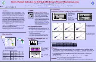
IntroductionMethod Results Conclusions 300 mm 9 h Q~ 100 Q mean • Storms • 300-400 mm in 6-12 h. over some 100s km2 • Watersheds • 100 to 1000 km2 • specific outflows of up to 5 m3s-1km-2 Hilly region between the Mediterranean sea and the Massif Central. Rainy autumns. HYDRAM Water depth seen by the Nîmes radar (Météo-France) October 6, 2001 Vidourle, October 6 – 7, 2001 Cévennes-Vivarais : a region prone to flash floods • Objective : forecast of these flash floods. • We focus here on the precipitation forecast.
IntroductionMethod Results Conclusions Precipitation forecast model We use Meso-NH (Météo-France, CNRS) : • ameso-scalenon-hydrostatic model • a nested configuration. The finest grid has a2.5 kmresolution which allows anexplicit resolution of the convection
IntroductionMethod Results Conclusions Reference observed rain fields • We use kriging : • an exact interpolator • it takes into account the statistical structure of the rain-gauge data • it gives an estimation of the reliability of the interpolation (estimation variance) Simulation and observation are observed for 1h and 11h cumulated rainfall.
IntroductionMethod Results Conclusions 1995 2001 Observations Simulation Quite a good localisation Not enough precipitation simulated (maximum cumulated rainfall of 100 mm vs. 170 mm) 1995 : Gardon d’Anduze Observations 2001 : Vidourle Simulation Bad localisation Not enough precipitation simulated (maximum cumulated rainfall of 160 mm vs. 260 mm) Cases studied Two simulations with very different qualities. The point is : • “how much better” is the better simulation ? • is it betterfor hydrological purposestoo ?
IntroductionMethod Results Conclusions R²(area) R²(area) Method Observation Forecast
IntroductionMethod Results Conclusions Method estimation error limit point to point correlation limit
IntroductionMethod Results Conclusions 1995 11 h cumulated rainfall 1995 1 h cumulated rainfall 1995 2001 Lower short-range accuracy for short time accumulation Evolution of the correlation with the area
IntroductionMethod Results Conclusions 2001 1995 Limits of the method
IntroductionMethod Results Conclusions Conclusions, perspectives • The method can discriminate good forecasts from very bad forecasts • We need other cases to test the method • The method must be tested with distributed data too (radars) • Next step : use of TOPODYN (LTHE), a hydrologic model from the TOPMODEL family. It considers several scales of the watersheds.