Download
1 / 12
120 likes | 251 Views
2011 Storm impacts on nutrients and sediment in the Susquehanna River Basin. Presentation for the Impacts of Tropical Storms Irene and Lee on the Hudson River Hudson River Environmental Society Cary Institute of Ecosystems Studies Wednesday September 19, 2012 Kevin McGonigal

E N D
2011 Storm impacts on nutrients and sediment in the Susquehanna River Basin Presentation for the Impacts of Tropical Storms Irene and Lee on the Hudson River Hudson River Environmental Society Cary Institute of Ecosystems Studies Wednesday September 19, 2012 Kevin McGonigal Environmental Scientist Susquehanna River Basin Commission
Where Towanda – Mostly NY Marietta – Above Dams What Precipitation Flows Loads Average Concentrations When September 6-day peak flow period How Estimator
Source data at: http://www.erh.noaa.gov/marfc/Precipitation/Departures/
Take home The “bad” Individual high flow events versus sustained high flows Increases in sediment due to scour of reservoirs The “good” Timing of storms At end of summer
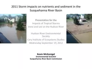
??Questions/Comments?? Image taken August 30 8/30/11 max 83,500 cfs Image taken September 13 9/9/11 max 778,000 cfs (>390,000 cfs= scour - USGS) Columbia, PA South of Route 462 aka Marietta Site 9/10/11 Satellite Image Source http://earthobservatory.nasa.gov