Download
1 / 23
250 likes | 634 Views
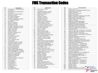
B737 GPS/FMS. Part 7: Flight Plan Exercise (Part 2). Select the FIX function key and insert YEA (or another nearby waypoint into <LSK 1L>. This provides bearing and distance information FROM to fix. To get bearing and distance TO the fix, toggle the green caret on <LSK 1R>.

E N D
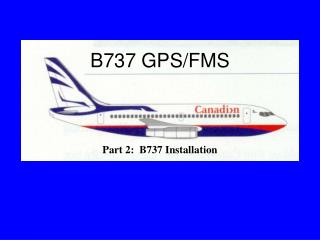
B737 GPS/FMS Part 7: Flight Plan Exercise (Part 2)
Select the FIX function key and insert YEA (or another nearby waypoint into <LSK 1L>. This provides bearing and distance information FROM to fix. To get bearing and distance TO the fix, toggle the green caret on <LSK 1R>. Down track fixes can be created based upon a radial or distance from the fix. For a radial, insert the radial in either <LSK 3L or 4L>. For a distance insert “/distance”I.e., /100, into <LSK 3L or 4L> To create an abeam point, LSK 5L> to create
To use one of the waypoints defined by a fix, line select the fix such as the abeam fix, <LSK 5L> into the scratchpad Go to the LEGS page and insert this waypoint at the appropriate location. Notice that the waypoint has been renamed to YEA02 (or 01, etc). These are user defined waypoints. A route discontinuity has also been inserted. This can be closed up by selecting the next waypoint into the scratchpad then moving it into the line select of the “disco” If these changes are satisfactory, EXEC. If not, either edit or ERASE to eliminate all changes since the last EXEC
To fly a parallel offset track, go to the RTE page. Insert the offset into the scratchpad with the direction (left or right - L or R) first followed by the distance Use <LSK 6R> to insert the offset into the FMS and EXEC if it is satisfactory. The aircraft will make a 45 degree turn toward the offset then fly the offset track. The OFST annunciator on the MCDU and the OFFSET on the annunciator bank will illuminate . To cancel the offset, insert 0 in the scratchpad and <LSK 6R> in the RTE page.
Along track waypoints can be created on the inbound (outbound) course to (from) the reference waypoint. To create this waypoint, either enter into the scratchpad the referenced waypoint or bring it down to the scratchpad using the <LSK>. The syntax for this is: ref waypoint/distance For a waypoint after the referenced waypoint, the distance is positive; before the referenced waypoint, the distance is negative and the negative sign must be used.
After creating the along track waypoint, insert it where appropriate and close up any discontinuities
Place/bearing/distance waypoints are created by the following syntax: place bearing/distance, as shown Similarly to the along-track waypoints, this new waypoint is inserted on the LEGS page at the appropriate spot and any discontinuities closed up
Details about the user defined waypoint can be found in INIT REF, NAV DATA. Use the LSK to move the waypoint into the scratchpad then INIT REF, NAV DATA and <LSK 1L>.
Place/bearing Place/bearing waypoints are created by the following syntax: Place bearing/place bearing, as shown Similarly to the along-track waypoints, this new waypoint is inserted on the LEGS page at the appropriate spot and any discontinuities closed up If the waypoint is physically impossible, the following alert will be displayed: “INVALID INTERSECTION) (See next slide)
If the waypoint is physically impossible, the following alert will be displayed:
Latitude Longitude waypoints can be created using the following syntax: latitude longitude, as shown Coordinates must be entered with whole degrees and/or minutes with a resolution of up to 0.01 minutes
Similarly to the along-track waypoints, this new waypoint is inserted on the LEGS page at the appropriate spot and any discontinuities closed up These waypoints will display the latitude and longitude (in degrees), as shown
To recall the exact values of the coordinates, use the LSK to pull the waypoint into the scratchpad
Three types of waypoints exist: • Fly-by (default) • Fly-over (Final Approach Fix (FAF) and Missed Approach Point (MAP) • Holding The fly-over waypoints have a “/o” next to the waypoint and the holding waypoints have a “/h”. Fly-by waypoints have no extra symbology. Waypoints can be changed by including or removing the symbology (with the exception of the FAF and MAP which cannot be changed.
To make a waypoint a fly-over, insert a “/o” onto the scratchpad then LSK it to the appropriate waypoint A waypoint can become a fly-by by placing a “/” in the scratchpad the LSK to the appropriate waypoint
Holds can be entered a variety of ways: • inserting the /H at a waypoint on the route • inserting a new waypoint with a /H attached • using the HOLD key for a present position hold • Refer to the CMA 900 Operator’s Manual for more details about holding entries and holding parameters • Caution: present position holds are not permitted with the CMA 900 operational software version -003D
Holds can be exited in a variety of ways: • using the EXIT HOLD LSK • Direct-To navigation to the holding fix • Direct-To any waypoint • Refer to the CMA 900 Operator’s Manual for more details about holding entries and holding parameters
In some cases, such as requesting direct to the “H” beacon, a duplicate identifier selection appears. Using the nomenclature found in the CMA 900 manual (pg 14-64) or the geographic coordinates, use the LSK to select the appropriate waypoint
It is now time to focus on the arrival into Toronto. The arrival is normally programmed by the PNF just prior to the Top of Descent. You anticipate an ILS approach to Rwy 24R. You are cleared for a Profile Descent RWY 24R with the DANNY arrival transition. Select DEP/ARR Select YMS24B STAR Select Danny Transition Select ILS24R Select D050N Appr Transition
Select LEGS After the route and descent information has been verified on the appropriate LEGS pages by both pilots, ‘EXECUTE’ on the command of the PF.
Select PROG page 4/4 Enter the destination altimeter setting. (LSK 6R) The altimeter setting is required to provide baro-corrected altitude to enable automatic sequencing of arrival or missed approach procedure legs with altitude terminations. Note: The BARO ALT <5R> will be displayed below 18000 ft.
Should a change be required to the approach transition, toggle LSK <2R> to provide the choice between the D050N or the X transition. Similarly, a change to ILS RWY 24L can be accomplished by using LSK <1R> to provide the choice of runways and then selecting an approach transition. Selecting “RUNWAY” 24L or 24R is intended for VFR use and provides information relative to the button of the selected runway. In all cases, both pilots must verify the routing prior to the PF stating “EXECUTE”.