Automatic Identification System
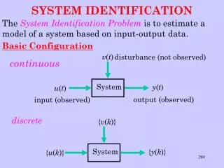
Automatic Identification System. LCDR Frank Elfring Program Engineer USCG Office of Vessel Traffic Management. Vessel Traffic Management Hierarchy. AIS Elements. Display Assemble Communicate. ARPA. Laptop. HDG COG Speed. GPS/ DGPS. ECDIS. ECS.

Automatic Identification System
E N D
Presentation Transcript
Automatic Identification System LCDR Frank Elfring Program Engineer USCG Office of Vessel Traffic Management
AIS Elements Display AssembleCommunicate ARPA Laptop HDG COG Speed GPS/ DGPS ECDIS ECS Displays incoming vessel information on a suitable device Gathers vessel movement information and assembles it into an AIS compliant data sentence. Initiates and controls the flow of data sentences between participating units
Hello Hello What is AIS? 20 Miles
MVEBOUND/ POSN/090/21/046/ 0112042498…... MVWBOUND/ POSN/270/23/035/ 0112142498…... What is AIS? 20 Miles
MVEBOUND/ POSN/090/21/046/ 0112642498…... MVWBOUND/ POSN/270/23/035/ 0112742498…... What is AIS? 20 Miles
HELLO What is AIS? 20 Miles HELLO
AIS Application MVInbound/POSN/335/332/14/21……………. MVOutbound/POSN/030/032/10/18………...
AIS Application MVInbound/POSN/335/332/14/21……………. MVOutbound/POSN/030/032/10/18………...
AIS’s Role SAFETY!
Positional ADF LORAN - A LORAN - C GPS DGPS ECS ANSWERS: Where am I? Situational Radar ARPA ANSWERS Where are they? Electronic Navigation Revolution
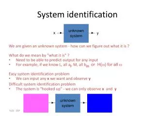
Automatic Identification System • Answers • Where am I • Where are they • Also Answers • Who are they • Which way are they headed • How fast are they going • and much more
A View From the Bridge • Mariner can choose to integrate AIS information into the bridge management system in a number of ways • ECDIS Overlay • ECS Input • ARPA • PC • One data string - many ways to display
Current VTS Coverage 900 Miles of Coastal shoreline (US) 794,704,946 Tons of Cargo 43,954 Import /Export Transits 40 miles of River and Intracoastal Shoreline $20 M O&M for infrastructure support Safety Level Miles of Shoreline
AIS Coverage Area(North America) 12,375 Miles of Coastal shoreline (US) 25,000 miles of River and Intracoastal shoreline 2,240,500,000 Tons of Cargo 182,768 Import /Export Transits $0 O&M cost for infrastructure support. (Ship to Ship Mode) Safety Level Safety Foundation Miles of Shoreline
12,375 Miles of Coastal shoreline (US) 25,000 miles of River and Intracoastal shoreline 2,240,500,000 Tons of Cargo 182,768 Import /Export Transits AIS/VTSCoverage Area(North America) Significantly Reduces O&M cost Safety Level Safety Foundation Other VTM tools VTS/VTIS Miles of Shoreline
Ship To Ship AIS • Raises safety across the board • Most desired feature • Provides situational presentation • on bridge • Technology exists • Product evolving
Enhanced AIS NON - CG Sources Weather Currents Depth PORTS Etc. CG C2 Node Alerts / Alarms Waterway Info Watchstander “Smart Tree” • Low $ solution to many traffic management issues • Maintain coverage in electronically blind areas • Insert emergency information from a C2 Center • May be integrated as part of NDS • Single Infrastructure /Multi-Mission capability • NOT a VTS but could transition to an emergency VTS • can remotely manage TSS, Maritime sanctuaries Vessel Provides: ID, position, course, heading, speed Vessel Receives: Information on vessels, port data, and hazards in area
VTS/VTIS based on AIS Emergency Info Alerts Vessel Data Processing System Watchstander Position Data Port Stake- holders' Information Radar data* Weather Currents Depth VTC * only where appropriate Vessel Provides: ID, position, course, heading, speed Vessel Receives: Information on vessels, port data, and hazards in area
AIS Standards Status Approved by MSC 5/11/98 N.B. Standards moving much more rapidly than normal.
AIS Development Cycle Implementation Development IDEA
The Process The USERS