Scale on old maps
Scale on old maps. Yale University Library Cataloging and Metadata Services. Scale. What is scale? The ratio of distances on a map, globe, relief model, vertical section or other cartographic item to the actual distances they represent on earth. Linear or bar scale Verbal scale

Scale on old maps
E N D
Presentation Transcript
Scale on old maps Yale University Library Cataloging and Metadata Services
Scale • What is scale? The ratio of distances on a map, globe, relief model, vertical section or other cartographic item to the actual distances they represent on earth. • Linear or bar scale • Verbal scale • Varying scale • More than one scale on the item being described
Why is it important in the bib record? • The information is critical in identifying a map and differentiating it from other maps with similar titles. • The information is of crucial importance to the user in determining if the map will show the level of detail they require. • Because cataloguing rules say it is!
How is scale recorded? • The representative fraction— • Record in this form at least • Allows comparison between maps • Useful in automated searching when also recorded in coded form in the 034 1:63,360 1 of any unit on the map equals 63,360 of the same unit on the ground
Representative fraction 1:6,842,880 Verbal scale 108 English Miles to 1 Inch Graphic or bar scale No scale information at all Types of scale statements found on rare maps
A word of warning… Unless the scale is 1:1, there are limitations to the accuracy of the methods used to derive the scale data. This is especially true on older materials, where the scale may vary considerably over the face of the map depending on the methods available to the cartographer. On modern maps, the projection used will affect the scale variation and distortion over the map.
Verbal scale statement The relationship that a small distance on a graphic bears to the corresponding distance on the Earth, expressed as an equivalence, such as 1 inch (on the graphic) equals 1 mile (on the ground). Some users may be more familiar with this type of information. However, it is very difficult to compare verbal scale statements in order to select the most appropriate map from the catalogue record, and virtually impossible to search or compare verbal scale statements in an automated catalogue.
The verbal scale statement • Scale may also be recorded in the record as a verbal scale statement, in other words, as it may appear on the map in addition to the RF. • Format for verbal scale statement: 1” = 1 mi. 2 in. to the mi. 255 __$aScale 1:63,360. 1 in. to the mi. Note: it’s ok to abbreviate in the verbal statement portion of the 255.
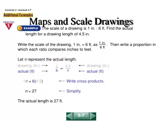
Converting verbal scale information to a representative fraction 1 inch to the mile 1” (on map) = 1 mile (on Earth) 1” = 5280 ft/mi x 12 in/ft 1” = 63,360 in RF 1:63,360
Graphic scales (1) • Bar scale statement
Measuring to convert graphic or bar scale information to a representative fraction
Graphic scales (2) Distances between parallels of latitude • Latitude is the measurement of degrees between the equator and the poles. • Latitude figures run along the sides of a map (when north is at the top). • Measure the natural scale indicator’s edge for 1° of latitude against the latitude figures near the center of the map.
Graphic scale (3) The map itself If all else fails, and you are determined to figure out a scale, compare a measurable distance on the map to the same distance on a map of known scale, for instance, in a modern atlas. There’s a formula for figuring the scale on the map you’re cataloging in CM, or:
Calculations to construct a representative fraction using the comparison method Say you have a map of England on which there is no scale statement at all. Measure the distance between two known points, for example, the distance on the map between London and Cambridge. On the map, London -> Cambridge = 10 inches On the Earth, London -> Cambridge = 60 miles 10” (on the map) = 60 mi. (on the Earth) 10” = 60 mi x 63360 in/mi 10” = 3801600” 1” = 380160” RF 1:380,160 highly approximate!
Recording the RFThe 255 is an odd mixture of recording exactly as it the data appears on the item and recording according to a standard formula. If it appears as an RF on the map, record as is. Scale 1:24,000. If you’ve calculated from a verbal scale, record in brackets. Scale [1:63,360]. If you measured against a bar or a map of known scale, record in brackets using ca. Scale [ca. 1:120,000].
So, if you have to record the scale as an RF but that is not given on the map, what do you do? • If you have a verbal scale statement on the map CONVERT! • If you have a bar scale on the map CALCULATE! • If you have no scale at all on the map COMPARE!
Troublesome units of measurement on old maps Chain Furlong Heures de marche League Lieue Miles (that aren’t statute) Milliaria Germanica, Hispanica, etc Pole Toise
Coding the scale in the 034 • Indicators: • First - Type of scaleA value that indicates the type of scale contained in the field. • 0 - Scale indeterminable/No scale recordedNo representative fraction is given in field 255. • 1 - Single scale • 3 - Range of scales • Second - Type of ring
Coding the scale in the 034 $a - Category of scale (NR)A one-character code that indicates the type of scale of the item. a - Linear scale b - Angular scale (used for celestial charts) z - Other type of scale $b - Constant ratio linear horizontal scale (R)The denominator of the representative fraction for the horizontal scale. $c - Constant ratio linear vertical scale (R)The denominator of the representative fraction for the vertical scale of relief models and other three-dimensional items. $d - Coordinates--westernmost longitude (NR) $e - Coordinates--easternmost longitude (NR) $f - Coordinates--northernmost latitude (NR) $g - Coordinates--southernmost latitude (NR)Subfields $d, $e, $f, and $g always appear together.
034 and 255 fields 255 __ $aScale 1:25,000. Or 255 __ $aScale [1:25,000]. Or 255 __ $aScale [ca. 1:25,000]. 034 1_ $aa$b25000
Other possible scale statements • Scale ca. 1:500,000.{Map says scale is approximate} • Scale [1:25,344]. 2½” to the mi. {Map says scale is 2½” to the mile} • Scale [1:50,000].{Scale is taken from cover etc} • Scale [ca. 1:63,360].{Measured from bar scale} • Scale not given.{Not on map and can’t or won’t figure it out!} • Scale varies.{As on bird’s eye views} • Scales differ.{More than 1 map being described in 1 record} • Not drawn to scale.{Often with manuscript maps} • Scale indeterminable is now out of fashion.
A few things not to worry about… • Longitude • Meridians • Graticules • “69½ miles to a degree”