Download

1 / 13
130 likes | 182 Views
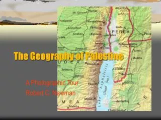
Explore the geographical setting of ancient Palestine, located between Egypt and Mesopotamia, with diverse regions like coastal plains, hill country, and rift valleys. Learn about the climate and dimensions of this historic land.

E N D
See “Map of Iron Age Sites” in Textbook, p. x. • Mazar, Archaeology of the Land of the Bible…pp. 1-9; See, especially Maps 1.1 on p. 2 and 1.2 on p. 5; • Most Bibles have good maps. • There are numerous Bible atlases.
Geographic Setting: - On the eastern shore of the Mediterranean Sea; - Between the ancient powers of Egypt and Mesopotamia (present-day Iraq);
Western Palestine and Eastern Palestine: Extent: - Fertile land in the country: 20,000 sq. km; Comparison with Nova Scotia: 55,491 sq. km (21,425 sq. mi.); - From Dan to Beesheba: 220 km; - From Dan to Elath on the Red Sea/Gulf of `Aqaba/Elath: 410 km;
Dimensions: - From Mediterranean Sea to the Jordan River: an average of 80 km; - From Haifa to the Sea of Galilee: 45 km; - From Gaza to the Dead Sea: 98 km; - Inhabited land in eastern Palestine/Transjordan is 40 km wide; - Fertile land in the country: 20,000 sq. km;
Palestine May Be Divided Into Four Main Geographical Regions: - The coastal plain; - The central hill country; - Rift valley; - Transjordanian plateau;
Climate: - The Middle East year may be divided into three seasons: - Summer, from mid-June to mid-September; - Rainy season from mid-October to mid- April; and - Transitional seasons which comprise the remainder of the year (desert storms and Sirocco/Khamsin;
Climatic Regions: - Mediterranean zone (average annual rainfal is 300 mm); - Semi-arid transition zone (average annual rainfall is 50-300 mm); and - Arid or desert zone (50 mm or less of precipitation per year);