Download
1 / 24
240 likes | 374 Views
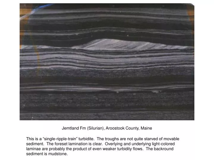
Jemtland Fm (Silurian), Aroostook County, Maine.

E N D
Jemtland Fm (Silurian), Aroostook County, Maine This is a “single-ripple-train” turbidite. The troughs are not quite starved of movable sediment. The foreset lamination is clear. Overlying and underlying light-colored laminae are probably the product of even weaker turbidity flows. The backround sediment is mudstone.
Minturn Fm (Pennsylvanian), Colorado The lenses of coarser sediment are trains of starved ripples deposited during flow events.
Prodelta deposits, glacial Lake Hitchcock, Connecticut Valley, Massachusetts The front face, a vertical section parallel to paleoflow is a riser. The surface on which the scale rests is a horizontal step. The back surface is also a riser. The step shows sets produced by climbing ripples. The step shows classic rib and furrow. Note that the truncated laminae on the step are concave downstream.
(courtesy of John Harms) Small-scale trough cross-lamination, in a vertical section normal to flow. Just from this face, you can’t tell whether flow was out of the section or into the section. The truncation surfaces that separate the interleaving “troughy” sets are concave upward, as are the conformable laminae within the sets.
Normanskill Fm (Ordovician), NY Rte 199, Red Hook, New York Depositional-stoss (“supercritical”) climbing-ripple cross lamination. This is in a turbidite succession. It might have been deposited on a channel levee, as the sediment-laden flow passed over the crest of the levee and decelerated, raining its load onto the ripples.
Chaco River, New Mexico (courtesy of John Harms) A series of flood events generated climbing-ripple beds, with upward-increasing angles of climb, as the ratio of sediment fallout rate to ripple migration speed increased. The actual ripple topography of the final event can still be seen, beneath the scale bar.
Prodelta deposits, glacial Lake Hitchcock, Connecticut Valley, Massachusetts. The blocks on the scale bar are in centimeters. Climbing-ripple cross stratification, starting at a low angle of climb and ending in almost vertical climb, as the ripples slowed while sediment was still raining out. The dark gray layer just above the scale bar is a winter-deposited clay layer, when the lake surface was frozen and no new coarser sediment was being supplied.
Ashley et al. flume experiments, MIT Starting with a rippled bed, sediment was showered onto the moving ripples from above, in individual “passes” along the channel, resulting in climbing ripples. Graphite flakes were mixed with the sediment, to emphasize the lamination.
Ashley et al. flume experiments, MIT A similar run, to simulate ripple climb starting with a weak flow, proceeding to a stronger flow, and ending with a weak flow. Note that the laminasets in the middle of the deposit are not entirely regular, because the ripples change speed with time and are “born” and “die” irergularly.
Nubian sandstone, Egypt (courtesy of John Harms) Large-scale “planar-tabular” cross stratification, presumably produced by migration of two-dimensional dunes.
(courtesy of Larry Boguchwal) Another example of planar-tabular large-scale cross stratification, from the Paleozoic of the central Appalachians.
Arkansas River near Tulsa, Oklahoma A trench in a river point bar. The left face is normal to flow, and the right face is parallel to flow. The flow-parallel face shows sets all facing to the left, downstream. The flow-normal face shows the characteristic trough sets.
Flow-normal section. Just from this cut, you would not know whether the flow was into or out of the face, without digging to see the third dimension.
San Rafael Swell, Utah (Paul Heller, Mariano Marzo, and Chris Paola) The two faces of the approximately rectangular-solid lock behind the cut-ups show vertical sections at right angles to one another. The next slide shows details.
In the left face, most of the sets are oriented in one direction. That section is nearly flow-parallel. The right face shows sets in both directions. That section is nearly normal to flow.
Stirling Quartzite (Neoproterozoic), southern Nopah Range, California Commonly, large-scale trough cross stratification looks like this in flow-normal view. The sets dip both to right and to left.
Elbow River near Moose Mountain, Alberta, Canada The cross-sets drip mainly to the left; the section is nearly flow-parallel.
Wood Canyon Fm (Neoproterozoic–Cambrian), southern Nopah Range, California The foreset laminae are nearly straight throughout most of the thickness of the set, but they become concave up as they approach the base of the set, fairing almost asymptotically down to the base.
I70, San Rafael Swell, Utah This is a (not-ideal) example of large-scale rib and furrow. You can see three sets, with curving laminae, separated by truncation surfaces.
I70, San Rafael Swell, Utah A three-dimensional view of a trough set. Paul Myrow is standing in the low point of the trough set, with laminae dipping toward us.
Brushy Canyon Fm (Permian), Delaware Mountains, West Texas It is unusual to see climbing-dune cross stratification, presumably because the supply of sediment from above is almost never large enough, relative to the speed of movement of the dunes, to cause a high angle of climb. This is from what must have been a large depression, filled by deposition from sediment gravity flows passing by. The dunes are climbing from left to right, at an angle large enough to preserve stoss-side lamination.
Grayburg Fm (Permian), Guadalupe Mountains, West Texas A single dune or bar, underlain and overlain by parallel-bedded sediment, moving toward us. The nice three-dimensional shape of the outcrop allows us to determine the direction of movement closely.
Tidal bundles, I70, San Rafael Swell, Utah A single dune, migrating from left to right. The sigmoidal recessive surfaces are defined by finer sediment, deposited on the dune surface during slack-water times in a daily tidal cycle (or, perhaps, during the neap phases of a neap–spring tidal cycle).