Future Needs in Geostationary Advanced Sounder Technology
10 likes | 128 Views
Exploring the need for high-resolution geostationary advanced sounders for improved severe weather forecasts and atmospheric monitoring. Understand the benefits and applications of advanced sounder technology.

Future Needs in Geostationary Advanced Sounder Technology
E N D
Presentation Transcript
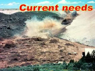
Current GOES Sounder applications and future needs Jun Li (Jun.Li@ssec.wisc.edu) Cooperative Institute for Meteorological Satellite Studies (CIMSS), University of Wisconsin-Madison, Madison, WI Timothy J. Schmit NOAA/NESDIS, SaTellite Applications and Research (STAR), Advanced Satellite Products Branch (ASPB) Madison, WI James J. Gurka NOAA/NESDIS, GOES-R Program Office, Greenbelt, MD Zhenglong Li CIMSS, University of Wisconsin-Madison, Madison, WI Jaime Daniels and Mitch Goldberg NOAA/NESDIS, STAR, Suitland, MD W. Paul Menzel CIMSS, University of Wisconsin-Madison, Madison, WI • The GOES Sounders have provided quality hourly infrared (IR) radiances and derived products over the continental U.S. and adjacent oceans for over 13 years. The products derived include: clear-sky radiances; temperature and moisture profiles; Total Precipitable Water vapor (TPW) and layer PW; atmospheric stability indices such as Convective Available Potential Energy (CAPE) and Lifted Index (LI); cloud-top properties; clear-sky water vapor winds via radiance tracking; and total column ozone. These products are used for a number of numerical weather prediction (NWP), short range forecasts and nowcasts, for example, severe weather forecasts. • Although the hyperspectral IR sounding system is not currently planned to be on the GOES-R series, the needs for future geostationary advanced sounder is valid. High temporal and spatial resolutions of geostationary advanced sounder are the unique aspects for severe weather forecast by • depicting important water vapor variations spatially and temporally; • improving thunderstorm predictions; • better emissivity determination over land; and • better detection and retrieval of low level inversions. Level 1 to Level 2 Level 2 to applications Thanks also to… Gary S. Wade, NOAA/NESDIS/ASPB Jinlong Li, CIMSS Xin Jin, CIMSS Many others Current GOES Sounder spectral coverage. 22 UTC to 00 UTC 14 April 2006 23 UTC, 13 April To 03 UTC, 14 April 2006 Hail Storm (April 13 – 14, 2006), Madison, WI The hail storm of April 13 – 14, 2006 caused damage to many houses in Madison area in Wisconsin. The storm produced large hails (left picture). The GOES-12 Sounder 11 µm image at 22 UTC on 13 April shows that a super cell is likely to be developed. The multispectral band classification (Li et al. 2003, JAM) shows that there are typical four classes of clear air mass surrounding the super cell, two hours later (00 UTC, 14 April 2006) the dry air moves toward east while the wetter air move towards north. The clear sky atmosphere is very unstable from 22 UTC to 00 UTC, and the super cell starts to develop. From 00 UTC on 14 April to 03 UTC on 14 April, the air masses continue to move and mixes each other, the super cell develops fast and becomes convective system. The soundings observed by GOES Sounder before and during the convective storm are very useful for short range storm forecasts. Operational Products from the current GOES Sounder and their applications. A latitude-longitude-altitude “cube” of 3D wind products retrieved from simulated GIFTS data Domain: •20 x 20 degrees horiz.•1000-400 hPa vertical. •Illustrating data density and vertical distribution potentially achievable with geo IR sounder •Velden et al., Bull. Am. Meteorol. Soc., 86, 205-223 (2005). AIRS coverage overlays on GOES imager (Hurricane Dean) Why geostationary hyperspectral sounding? (1) Water Vapor is the basic fuel for severe thunderstorms. Large variations in atmospheric water vapor occur over a scale of 10 km or better in the horizontal and 1 km in the vertical, large variations in water vapor occur over 10s of minutes, thunderstorms form or decay in 10s of minutes, severe thunderstorms form mostly over land, and accurate temperature and moisture profiles from satellite challenging due to land emissivity variations. (2) To support regional and convective-scale NWP over CONUS, through unprecedented detail on 3D fields of wind, temperature and humidity, at high vertical, horizontal and temporal resolution. (3) To support nowcasting and very-short range forecasting (VSRF). For example, to use 3D fields of wind, temperature and humidity for monitoring moisture convergence and convective instability, to help improve warnings of location and intensity of convective storms. (4) Geostationary hyperspectral sounder (GHS) temperature, moisture and wind profiles are critical for NWP and short range forecasts. GHS will provide a 3-D picture of moisture with the temporal and spatial scale necessary to forecast individual thunderstorms, the hyperspectral coverage from GHS will show the variations in surface emissivity necessary for accurate temperature and moisture profiles and radiance data assimilation over land. GHS will show low level temperature inversions, critical for severe thunderstorm forecasts, provide 500 m to 1 km vertical resolution for temperature and moisture profiles. Hyperspectral IR emissivity map derived from AIRS (Li et al. 2007 – GRL)