Tropical Development Update: TD18F's Track and Intensification Forecast (March 9, 2023)
Tropical Depression TD18F, located at 12°UT, is currently moving west at 8 knots. The system is being steered westward by a strengthening upper-level ridge, with good outflow to the north. Predictions indicate TD18F will continue westward before curving southeast and intensifying. Satellite images indicate a very cold tropopause, and model forecasts show consensus on the convergence area from Vanuatu to Fiji. Monitoring of the region is crucial for safe passage as impacts may vary.

Tropical Development Update: TD18F's Track and Intensification Forecast (March 9, 2023)
E N D
Presentation Transcript
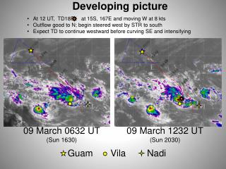
Developing picture • At 12 UT, TD18F at 15S, 167E and moving W at 8 kts • Outflow good to N; begin steered west by STR to south • Expect TD to continue westward before curving SE and intensifying 09 March 0632 UT (Sun 1630) 09 March 1232 UT (Sun 2030) Guam Vila Nadi
Nadi soundingscontinuing very cold tropopauses Sat nite very cold trop: 88.3 hPa, -88.1°C = 185 K Sun nite very cold trop: 86.7 hPa, -88.9°C = 184 K
00 UT Monday: two different forecasts 160 180 GFS 06Z 10S TD18F @ 00UT Surface winds Vanuatu/Fiji convergence line in red 6-hr precip 850 hPa vorticity NVG 12Z • GFS forecast has a bit more precip north of Fiji; otherwise models are in good agreement on arc of convergence through Vanuatu and east to Fiji • Red Box in each panels shows region of safe passage • penetrating farther southward will depend on what IR sat pix look like