Download
1 / 5
50 likes | 177 Views
This draft outlines a comprehensive conceptual model for Bay margins, presented to the Coastal and Floodplain Working Group on June 10, 2009. The document consists of three main elements: a review of existing information encompassing local contamination sites and watershed data; a summary of current conceptual understanding linking margins to environmental impairment and recovery; and recommendations for further research and model development. Key areas include contamination mobility, degradation processes, and the establishment of a general margin model that integrates watershed and Bay/Ocean studies.

E N D
Draft Outline for Bay Margins Conceptual Model Presented to the CFWG June 10, 2009
Three Main Pieces • Review of existing information • Summary of present conceptual understanding • Recommendation for next steps
1. Review of existing information • Local information: • Contaminated site cleanup • Alameda NAS, Hunters Point, Moffet Field, San Leandro Bay, Richmond Field Station • Watershed data • Loads, soils, etc. • Bay data • Estimating margins relative to Bay proper • Trends - can we say anything about degradation and attenuation? • Comparison to other estuaries (short narrative)
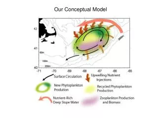
2. Summary of conceptual understanding • Linking margins to impairment • Mobilization from watersheds • Delivery to nearshore areas (margins) • Fate on margins • Burial, degradation, uptake to foodweb • Release from margins to open Bay • Transfer from open ay to margins • Forecasting recovery • Why are sites wtill contaminated? • Loading? Slow degradation? Slow flushing? • Is monitored recovery a viable option? • Degradation and attenuation • What are the high leverage pathways? • Where are contaminants entering the food web?
3. Recommendations for next steps • Desire for a “general margin model” • What is it? How do we get there? • Grid model development • Link to watershed studies • Link to Bay/Ocean modeling • Suggested future studies • Fieldwork to support models • Fieldwork to support monitored recovery