Download
1 / 99
1.01k likes | 1.49k Views
2010 Dynamic Planet: Earthquakes and Volcanoes. Presented by Linder Winter. Use of this PowerPoint Presentation. All images and content obtained from the web for use in this PowerPoint presentation falls under the Fair Use Policy for educational use.

E N D
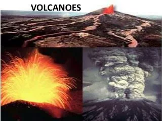
2010 Dynamic Planet: Earthquakes and Volcanoes Presented by Linder Winter
Use of this PowerPoint Presentation • All images and content obtained from the web for use in this PowerPoint presentation falls under the Fair Use Policy for educational use. • You may freely burn and distribute as many copies of this presentation as you wish. • Feel free to alter this presentation in any way you wish. • If you identify someone willing to coach this event, provide that individual with a copy of this CD to introduce him/her to the requirements of the event.
Student Developed PPT. Presentations • Encourage participants to develop their own PowerPoint presentations as a way to prepare for this event. • Suggest that participants first enter the event topics into their PowerPoint presentations similar to an outline. • As participants search the web for specific topics they will frequently find information about other topics included in the event. They can “fill-in” that information immediately. • As participants discover better or more relevant informa-tion, they may replace previous material with newly the newly discovered material. • Suggest that students “hold off” developing their resource pages until they are well satisfied with their PowerPoints.
Dynamic Planet: Event Rotation • 2009 & 2010: Earthquakes & Volcanoes • 2011 & 2012: Earth’s Fresh Waters • 2013 & 2014: Glaciers • 2015 & 2016: Oceanography
1. DESCRIPTION • Students will use process skills to complete tasks related to earthquakes and volcanoes. • A team of up to: 2 • Approximate time: 50 minutes
2. EVENT PARAMETERS • Each team may bring one 8.5” x 11” two-sided page of notes containing information in any print format from any source. Each participant may also bring a “non-graphing” calculator.
THE COMPETITION • Participants will be presented with one or more tasks, many requiring the use of process skills (i.e. observing, classifying, measuring, inferring, predicting, communicating and using number relationships – source: AAAS) for any of the following topics: Each addressed separately.
Coaching Tips and Hints: Resources • Resources are to knowledge events as projects are to construction events. • Students develop their own resources; no hand-me-downs! • Participant-produced resources provide an oppor-tunity for coaches to frequently and easily monitor participant progress. • Encourage continual revision of resources, i.e. after each level of competition, when participants feel confident with their knowledge of specific topics, etc.
Coaching Tips and Hints: Resources Suggested items to include in student resources: • Definitions • Characteristics of the various types of volcanoes • Diagrams and illustrations • Characteristics of P, S and surface seismic waves
Coaching Tips and Hints • With the growing complexity of the events, it is very difficult, if not impossible, to coach all the events without assistance. • Should you find someone willing to coach the Earthquakes and Volcanoes event, give him/her a copy of this PowerPoint presentation to provide an overview of the event.
Representative Activities • Interpretation of charts, tables, diagrams (many of the diagrams included in this presentation may be developed into an activity. • Locating the epicenter of a volcano • Patterns of volcanic and earthquake patterns around the world (mapping) • Identification of volcanic features • Match volcanic features with popular examples, i.e. Devil’s Tower – Volcanic Neck; Crater Lake – Caldera
Coaches’ Resources • Information on all topics identified in the event rules may easily be found on the web. Choice of “key words and phrases” are the keys to success! • Be certain to caution participants to use only professional websites in their search for information. These include the USGS, college sites, etc. • Middle/Junior/Senior High Earth Science Textbooks, and even Introductory college textbooks • *The Game of Earth, NEW 2010 Edition • *The Theory of PLATE TECTONICS CD *http://www.otherworlds-edu.com
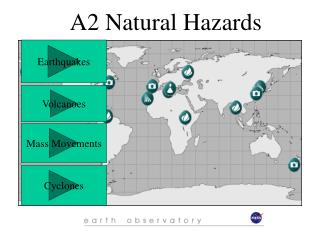
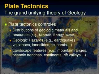
a. Worldwide distribution patterns of earthquakes and volcanoes
Types of Volcanoes: Shield Volcanoes • Shield volcanoes are huge in size. • They are built up by many layers of runny lava flows spilling out of a central vent or group of vents. • The broad shaped, gently-sloping cone is formed from basaltic lava which does not pile up into steep mounds.
Types of Volcanoes: Stratovolcanoes(Composite) • Tall, conical volcanoes with many layers (strata) of hardened lava, tephra and volcanic ash • Characterized by steep profiles and periodic, explosive eruptions • Lava tends to be viscous (very thick) • Common at subduction zones where oceanic crust is drawn under continental crust
Types of Volcanoes: Cinder Cones • A cinder cone is a steep conical hill of volcanic fragments that accumulate around and downwind from a volcanic vent. • The rock fragments, often called cinders or scoria, are glassy and contain numerous gas bubbles "frozen" into place as magma exploded into the air and then cooled quickly. • Cinder cones range in size from tens to hundreds of meters tall. Cinder cones are made of pyroclastic material.
Types of Volcanoes: Active, Dormant, Extinct (According to U.S.G.S.) • An active volcano to volcanologists is a volcano that has shown eruptive activity within recorded history. • A dormant volcano is somewhere between active and extinct. A dormant volcano is one that has not shown eruptive activity within recorded history, but shows geologic evidence of activity within the geologic recent past. An extinct volcano is one that is both inactive and unlikely to erupt again in the future. • An extinct volcano is a volcano that has not shown any historic activity, is usually deeply eroded, and shows no signs of recent activity.
Volcanic Hazards Potential activity!
Primary Volcanic Hazards: Pyroclastic Flows • Pyroclastic flows are fast-moving, avalanche-like, ground-hugging incandescent mixtures of hot volcanic debris, ash, and gases that can travel at speeds in excess of 150 km per hour.
Primary Volcanic Hazards: Lahars • Lahars, also known as mud flows or debris flows, are slurries of muddy debris and water caused by mixing of solid debris with water, melted snow, or ice.
Primary Volcanic Hazards: Tephra • Tephra (ash and coarser debris) is composed of fragments of magma or rock blown apart by gas expansion. • Tephra can cause roofs to collapse, endanger people with respiratory problems, and damage machinery. • Tephra can clog machinery, severely damage aircraft, cause respiratory problems, and short out power lines up to hundreds of miles downwind of eruptions.
Primary Volcanic Hazards: Gases • The concentrations of different volcanic gases can vary considerably from one volcano to the next. • Water vapor is typically the most abundant volcanic gas, followed by carbon dioxide and sulfur dioxide. • Other principal volcanic gases include hydrogen sulfide, hydrogen chloride and hydrogen fluoride. • A large number of minor and trace gases are also found in volcanic emissions, for example hydrogen, carbon monoxide, halocarbons, organic compounds, and volatile metal chlorides.
Primary Volcanic Hazards: Lava Flows • Lava flows are generally not a threat to people because generally lava will move slowly enough to allow people to move away; thus they are more of a property threat.
Primary Volcanic Hazards: Flood Basalts • A flood basalt or trap basalt is the result of a giant volcanic eruption or series of eruptions that coats large stretches of land or the ocean floor with basalt lava. • Image: Moses Coulee showing former, multiple flood basalt flows of the Columbia River Basalt Group.
Secondary Volcanic Hazards: Flooding • Drainage systems can become blocked by deposition of pyroclastic flows and lava flows. Such blockage may create a temporary dam that could eventually fill with water and fail resulting in floods downstream from the natural dam. • Volcanoes in cold climates can melt snow and glacial ice, rapidly releasing water into the drainage system and possibly causing floods.
Secondary Volcanic Hazards: Famine • Several eruptions during the past century have caused a decline in the average temperature at the Earth's surface of up to half a degrees Fahrenheit for periods of one to three years. • Tephra falls can cause extensive crop damage and kill livestock which may lead to famine.
Types of Earthquakes: Spreading Center • An oceanic spreading ridge is the fracture zone along the ocean bottom where molten mantle material comes to the surface, thus creating new crust. • This fracture can be seen beneath the ocean as a line of ridges that form as molten rock reaches the ocean bottom and solidifies
Types of Earthquakes: Subduction Zone • Major earthquakes may occur along subduction zones. • The most recent sub-duction zone type earth-quake occurred in 1700. • Scientists believe, on average, one subduction zone earthquake occurs every 300-600 years.
Types of Earthquakes: Transform Fault • A transform fault is a special variety of strike-slip fault that accommo-dates relative horizontal slip between other tectonic elements, such as oceanic crustal plates
Types of Earthquakes: Intraplate • Intraplate seismic activity occurs in the interior of a tectonic plate. • Intraplate earthquakes are rare compared to earthquakes at plate boundaries. • Very large intraplate earthquakes can inflict very heavy damage. Distribution of seismicity associated with the New Madrid Seismic Zone since 1974.
Primary Earthquake Hazards: Rapid Ground Shaking • Ground shaking, a principal cause of the partial or total collapse of structures, is the vibration of the ground. • The first wave to reach the earth's surface, the P wave, causes a building to vibrate. • The most damaging waves are shear waves, S waves, which travel near the earth's surface and cause the earth to move at right angles to the direction of the wave and structures to vibrate.
Primary Earthquake Hazards: Rapid Ground Shaking • Buckled roads and rail tracks Structural Damage
Secondary Earthquake Hazards: Rapid Ground Shaking Landslides Avalanches
Secondary Earthquake Hazards: Rapid Ground Shaking Alterations to Water Courses Fire resulting from an earthquake
Earthquake Hazards: Shake Map • The Shake Map for the 1994 magnitude 6.7 Northridge, CA earth-quake shows the epicenter at the location of the green star. • The intensity of shaking created by the earthquake is shown by the different color gradients on the map. • The magnitude of the earthquake is 6.7 no matter where you are, but the intensities vary by location.
Structural Engineering Practices • Early alert capabilities in some cases will allow some systems to automatically shut down before the strong shaking starts so that the services and people using them will be safe. Such systems may include elevators, utilities such as water and gas, and factory assembly lines.
Volcanic Monitoring: Geologic History • The first thing scientists do is determine a volcano's eruption history. A volcano is classified as active, dormant or extinct based upon when it has last erupted. • Active volcanoes are in the process of erupting or show signs of eruption in the very near future. • Dormant volcanoes are "sleeping." This means they are not erupting at this time, but they have erupted in recorded history. • An extinct volcano has not erupted in recorded history and probably will never erupt again.
Volcanic Monitoring: Associated Earthquake Activity Each type of ground-shaking event usually generates a unique seismic "signature" that can be recognized and identified as having been "written" by a specific event.
Volcanic Monitoring: Magma Movement Earthquake activity beneath a volcano almost always increases before an eruption because magma and volcanic gas must first force their way up through shallow underground fractures and passageways. When magma and volcanic gases or fluids move, they will either cause rocks to break or cracks to vibrate. When rocks break high-frequency earthquakes are triggered. However, when cracks vibrate either low-frequency earthquakes or a continuous shaking called volcanic tremor is triggered.
Volcanic Monitoring: Satellite Data • Satellites can record infrared radiation where more heat or less heat shows up as different colors on a screen. If a volcano is seeming to become hotter, then an eruption may be coming soon.
Earthquake Monitoring: Identification of Faultlines New Madrid, Tennessee San Andreas Faultline
Earthquake Monitoring: Remote Seismograph Positioning • Scientists consider seismic activity as it is registered on a seismometer. • A volcano will usually register some small earthquakes as the magma pushes its way up through cracks and vents in rocks as it makes its way to the surface of the volcano. • As a volcano gets closer to erupting, the pressure builds up in the earth under the volcano and the earthquake activity becomes more and more frequent.
Earthquake Monitoring:Analog vs. Digital This is an image of an analog recording of an earthquake. The relatively flat lines are periods of quiescence and the large and squiggly line is an earthquake. Below is a digital seismogram. The data is stored electronically, easy to access and manipulate, and much more accurate and detailed than the analog recordings.
Earthquake Monitoring: Tiltmeter • When a volcano is about to erupt, the earth may bulge or swell up a bit. • Tiltmeters attached to the sides of a volcano detect small changes in the slope of a volcano. Installing a tiltmeter
Earthquake Monitoring: Changes in Groundwater Levels • Hydrogeologic responses to large distant earthquakes have important scientific implications with regard to our earth’s intricate plumbing system. • The exact mechanism linking hydrogeologic changes and earthquakes is not fully understood, but monitoring these changes improves our insights into the responsible mechanisms, and may improve our frustratingly imprecise ability to forecast the timing, magnitude, and impact of earthquakes.
Earthquake Monitoring: Observations of Strange Behaviors in Animals • The cause of unusual animal behavior seconds before humans feel an earthquake can be easily explain-ed. Very few humans notice the smaller P wave that travels the fastest from the earthquake source and arrives before the larger S wave. But many animals with more keen senses are able to feel the P wave seconds before the S wave arrives. • If in fact there are precursors to a significant earthquake that we have yet to learn about (such as ground tilting, groundwater changes, electrical or magnetic field variations), indeed it’s possible that some animals could sense these signals and connect the perception with an impending earthquake.
Volcanism at Plate Boundaries Encyclopædia Britannica, Inc.