Download

1 / 31
340 likes | 653 Views
Invest 2.2.1 Sediment Retention model. Yonas Ghile. Why care about ecosystem services? InVEST Sediment Retention Model Hands-on Exercise Case study. Talk Overview. What are Ecosystem Services?. InVEST: Science in a Simple Tool.

E N D
Invest 2.2.1 Sediment Retention model YonasGhile
Why care about ecosystem services? • InVEST • Sediment Retention Model • Hands-on Exercise • Case study Talk Overview
InVEST: Science in a Simple Tool Integrated Valuation of Ecosystem Services and Tradeoffs
InVEST Attributes • Evaluate change • Biophysical & monetary • Open source • Multiple services • Spatially explicit • Production functions Models Simple Complex Data Tier 0 Tier 1 Tier 2 Tier 3
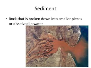
Why sediment retention model? • Soil erosion and sediment can cause: • Decrease in agricultural productivity, • Degradation of fish habitat and aquatic life, • Risk of structural failures • water quality degradation. • Increase maintenance cost
Questions you get answers • Where are the Sediment sources? • Where are the Sediment retention areas? • How much is retained? • What is the Value of this retention?
Informs Policy Makers to • Focus protection on areas that retain the most and pollute the least • Design management practices that lead to maximize retention • Create payment programs to get most return on investment (with tier2) • Identify places where other economic activities will conflict with erosion control • How much costs can be avoided under future management or conservation plans?
Sediment Retention Model Conservation factor Slope Erosivity Soil Erodibility Crop factor Sediment loads
Valuation Critical Loading Loading Time
Strengths • Uses readily available and minimum data. • Simple, applicable and spatially explicit • Link the biophysical functions to economic values • Values each parcel on the landscape
Limitations • Predicts erosion from sheet wash alone • Considers only individual effect of each variable • Relies on retention and filtration efficiency values for each LULC • Neglects the role of topography, soil, climate in the retention processes • Accuracy limited in mountainous areas
Model Calibration and Testing • Sensitivity Analysis to identify most sensitive parameters • Model Calibration using long term average actual data • Find USLE parameters within acceptable ranges • Validate Model by conducting comparisons with observed data or other model output
Hainan Island, China Simulated vs Observed Soil loss (103 t)
Hainan Island, China 2008 NRPE RNF RNF IEM 400 300 Soil Loss (103 ton) 200 100 0 Nandujiang Wanquanhe Changhuajiang
Scenarios for Mine Expansionin Columbia Permits Granted Current Mines All possible permits Permits Pending
Mining in Columbia Sediment Load (t/ha/yr) Permits Granted Permits Pending All possible Permits
Mining in Columbia High Impact Zones should avoided Permits Granted Permits Pending All possible Permits
Coming up soon in InVEST • Sediment delivery ratio • Gully and bank erosion (tier 0) • Dam retention • Multiflow algorithm • Will run faster • Improved Length Slope equation West Coast East Coast Belize Colombia Mexico Ecuador Amazon Basin Tanzania Indonesia
Hands-on Session • Run the soil loss model
Hands-on Session • Run the valuation model
Hands-on Session Think about how you would use theSediment Retention Model in your work?
How Does it Work? • Natural Characteristics: • R – Rainfall Erossivity • K – Soil Erodibility • LS – slope-length factor • Land Use Land Cover Management Practices: • C – conservation factor • P – Practice factor
Biophysical Inputs Land Use/Land Cover Vegetation retention, land practice and management Streams Used to determine where sediment flows to Watershed Areas Main and sub for point of interest and water quality analysis Slope Digital elevation model, slope threshold Erosivity Based on intensity and kinetic energy of rainfall Reservoir Features Dead volume, lifetime of reservoir, allowed load Erodibility Soil detachment and transport potential due to rainfall
Biophysical Outputs Potential Soil loss Calculated from USLE per sub-watershed Sediment Exported Calculated per sub-watershed Used in valuation Sediment Retained Calculated per sub-watershed
Valuations Valuation Inputs Valuation Outputs Watershed Areas Main and sub for point of interest and water quality analysis Value of Sediment Removal for Dredging Sediment Exported From biophysical analysis Value of Sediment Removal for Water Quality Sediment Retained From biophysical analysis Sediment Valuation Reservoir dredging costs
How Does it Work?... • Data inputs for Soil Erodibility • Percent Silt, %Slt • Percent Very Fine Sand, %VFS • Percent Clay, %Cly • Percent Organic Matter, %OM • Soil Structure Code, SC • Profile Permeability, PP
How Does it Work?... * For low slopes For high slopes • LS: Slope length factor • Original LS was calculated from plots of 72.6 feet long and 9% slope • The steeper and longer the field the higher is the risk of erosion.
How Does it Work?... Hydraulic connectivity model
How Does it Work?... 1.) 2. Removal of sediments by vegetation along the flowpaths is calculated as follows
How Does it Work?... • Sediment Yield is defined as the potential soil loss from terrestrial sources that might get into a water body • Value of removed sediment at pixel x: corn forest wheat forest Stream Cumulative Sediment Yield