Download
1 / 57

E N D
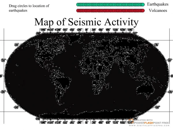
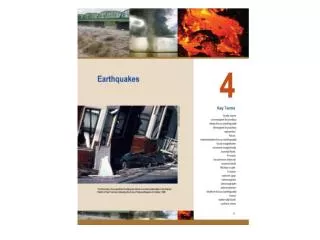
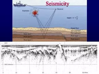
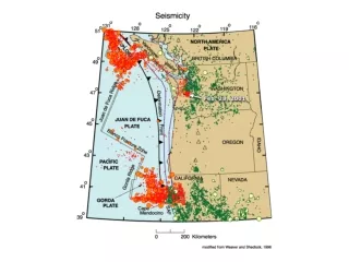
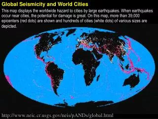
Global Seismicity and World Cities This map displays the worldwide hazard to cities by large earthquakes. When earthquakes occur near cities, the potential for damage is great. On this map, more than 39,000 epicenters (red dots) are shown and hundreds of cities (white dots) of various sizes are depicted. http://www.neic.cr.usgs.gov/neis/pANDs/global.html
Continental mountains (10.3%) ) % 2 9. 2 ( Ocean ridges (22.1%) D N Continental platforms (18.9%) A L Continental shelf and slope (11.4%) Ocean basin floors (29.8%) ) % 8 0. 7 ( N A E C O Continental rise (3.8%) Island arcs, trenches, guyots etc. (3.7%)
An ocean of superlatives, the Pacific covers about a third of the globe. This largest of oceans includes the world's deepest point, Challenger Deep, which plunges farther below the sea's surface than the tallest mountain, Everest, rises above it.
Just more than half the size of the Pacific, the Atlantic is the second largest ocean. Its central underwater mountain range, the Mid-Atlantic Ridge, was not directly seen or explored until 1973.
http://www.nationalgeographic.com/monterey/ax/primary_fs.htmlhttp://www.nationalgeographic.com/monterey/ax/primary_fs.html
A view of the Monterey Canyon http://www.oac.ucla.edu/people/yafang_su/vis/abaycolor2.gif
Monterey Canyon — another view http://www.oac.ucla.edu/people/yafang_su/vis/abaycolor.gif
The Indian Ocean is the world's third largest, making up one-fifth of earth's total ocean area. The Mid-Indian Ridge constitutes an area of seafloor spreading.
Cold waters off Antarctica, sometimes called the Southern Ocean, form a distinct ecosystem. Vast stocks of shrimp-like krill support, directly or indirectly, virtually all Antarctic wildlife.
The world's widest continental shelves create relatively shallow seas around the rim of the Arctic. Below pack ice, pushed by wind and currents, ocean floor depths plunge almost three miles.
Perspective is looking northeast from the Pacific Ocean towards Los Angeles and Palos Verdes. http://walrus.wr.usgs.gov/pacmaps/la_pers2.html
The world distribution of continental rises ( ) and deep sea trenches ( )
http://terraweb.wr.usgs.gov/projects/MontereySonar/georef.htmlhttp://terraweb.wr.usgs.gov/projects/MontereySonar/georef.html Monterey Bay Regional Geographic Reference Map
In this image, the viewer has been positioned to the west of the image at an elevation angle of 25º above the ocean (65º from directly above). The topographic relationships between the on-land mountains, ocean shelf, slope and basin are easily seen in this image.
This is the same as the previous image, but with color coded bathymetry.
The beach Material is typically classified according to diameter 27 — 28 mm 25 — 26 mm 22 — 24 mm 21 mm 2-4 — 20 mm 2-8 — 2-4 mm 2-9 — 2-12 mm Boulder Cobble Pebble Granule Sand Silt Clay
Distribution and thickness of world’s sediments Physio-graphic Province
Sahara Desert, Africa Dull opaque surfaces due to erosion from high speed winds. Desert sands tend to have a wider assortment of grain sizes. On the other hand, sand found near water has its sediments constantly sifted, thus depositing grains that are nearly the same size.
Current velocity and grain size determine erosion, transportation and deposition of sediments 1000 Erosion and Transportation 100 Current Velocity (cm/s) 10 Transportation Deposition 1 0.1 0.001 0. 01 0. 1 1 10 100 Grain Diameter (mm)
Punalulu, Hawaii The sand of Hawaii's black beaches is obsidian - volcanic glass created by magma that flowed to the sea and then cooled rapidly. It was eventually reduced to bits of fine black sand by water and waves.
Lifuka Island, Tonga, SW Pacific Remains of tiny sea animals called crinoids (sea lily) make up part of the sand in this area of the South Pacific. These stony disks which are calcified, wheel-like plates, fall in large numbers to the bottom of the ocean.