Download
1 / 33
330 likes | 356 Views
Explore active microwave systems in ocean and atmosphere monitoring, covering scatterometers, altimeters, synthetic aperture radar, and more. Learn about satellite altimetry, radar technology, and the history of altimetry missions.

E N D
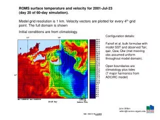
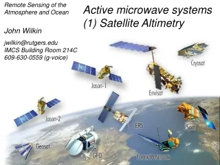
Remote Sensing of the Atmosphere and Ocean Active microwave systems(1) Satellite Altimetry John Wilkin jwilkin@rutgers.eduIMCS Building Room 214C609-630-0559 (g-voice)
Active microwave instruments • Scatterometer (scattering from surface roughness) • ocean vector winds • Synthetic Aperture Radar (SAR) • sea ice • high resolution wind speed over water • land mapping: surface roughness and 3-D terrain • surface currents and swell • CODAR • coastal ocean surface vector currents • Altimeter
Active microwave instruments • Altimeters (nadir pointing radar) • sea surface height (long wavelengths ~50 km) • mesoscale currents, eddies, fronts • thermal expansion • significant wave height • wind speed • gravity and bathymetry • ice sheets http://www.aviso.oceanobs.com http://topex-www.jpl.nasa.gov http://earth.esa.int/brat/html/general/overview_en.html
Microwave energy is largely unaffected by the atmosphere: It has almost 100% transmission
Radar systems operate in the microwave region of the EM spectrum Ku-band 13.6 GHz C-band 5.3 GHz Poseidon dual-frequency altimeteron Topex, Jason-1 and Jason-2 http://topex-www.jpl.nasa.gov/technology/instrument-altimeter.html
Key Components of any Radar System • Microwave transmitter – electronic device used to generate the microwave EM energy transmitted by the radar • Microwave receiver – electronic device used to detect the microwave pulse that is reflected by the area being imaged by the radar • Antenna – electronic component through which microwave pulses are transmitted or received (usually shared on satellite systems)
The relationship between:power received P and power transmitted PTis given by the radar equation (1) (2) (3) • Power of EM wave at range R. G = gain of antenna • Radiant intensity in the direction of the radar produced by scatter from a surface with a scattering cross-section s (which depends on area of target, fraction of incident radar pulse absorbed and scattered) • Aeis antenna effective area1/(4pR2) is isotropic spreading over range R in both transmittedand received signal
Satellite Altimeters • altimeters are nadir-pointing satellite-based radars used to measure the height of the surface of the Earth • transmit a radar pulse that is reflected from the Earth’s surface • measure the time it takes for the pulse to travel to Earth and back, t • range from satellite to surface is R = ½ ctwhere c = speed of light • Precision Orbit Determination (POD) systems measure the altitude of the satellite above a reference ellipsoid • c = 3 x 10⁸ m/s • satellite altitude ~ 1200 km • t = 2R/c = 0.008 s = 8 milliseconds • Poseidon uses 1700 pulses per second
ERS-1 1991-2000 Skylab 1973-1974 Seasat 1978 Geosat 1985-1990 GFO 1998 - Topex/Poseidon1992 – 1/5/2006 History of Altimetry OSTM/Jason-2 2008 - Envisat 2002 - Cryosat-2 April 8, 2010 - Jason-1 2001 - http://www.youtube.com/watch?v=cSaYIIBZk10 ERS-2 1995 -
Sea surface HEIGHT (SSH) • Sea Surface Height is satellite altitudeminusrange • It comprises two contributions: geoid and dynamic topography • Geoid: • The sea surface height that would exist without any motion. This surface is not “flat” because of gravity variations around the planet due to mass and density differences associated with the seafloor. The geoid is a geopotential surface. • Major bathymetric features deform sea level by tens of meters and are visible as hills and valleys of the geoid • Dynamic topography • The ocean circulation comprises a permanent mean component linked to Earth's rotation, mean winds, and density patterns… • …and a highly variable component (wind variability, tides, seasonal heating, mesoscale eddies)
Altimetry: How it works Precision orbit determination Corrected radar range Reference ellipsoid Satellite position is determined relative to an arbitrary reference surface - an ellipsoid. This reference ellipsoid is a raw approximation of Earth's surface, a sphere flattened at the poles. The altitude of Jason above the reference ellipsoid is measured to within 3 cm.
Geoid height (meters) 80 -80
Sea surface HEIGHT (SSH) Sea Surface Height is: ssh = altitude minusrange Geoid and dynamic topography: • To derive the dynamic topography,D, the easiest way would be to subtract the GEOID height from SSHD = ssh – geoid = alt – range – geoid • In practice, the geoid is not yet known accurately enough for many applications and mean sea level is commonly subtracted instead. This yields the variable part of the ocean signal (but removes the mean ocean circulation)
The slope of the sea surface relative to the geoid is directly related to the geostrophic current that balances the pressure gradient (due to the sea surface gradient) and the Coriolis force The long-term mean ocean circulation has an associated mean dynamic topography that is a permanent component of the time-mean orbit range as a function of position.
Jason-1 satellite AVISO Web site http://www.aviso.oceanobs.com/en/missions/current-missions/index.html
Satellite orbit and tracking • The critical orbital parameters for satellite altimeter missions are altitude, inclination and period • Topex/Poseidon and Jason satellites (same orbit) • altitude 1336 km • relatively high: less drag and more stable orbit • inclination of 66° to Earth's polar axis • it can "see" only up to 66° North and South • the satellite repeats the same ground track every 9.9156 days • the ground-tracks are 315 km apart at the equator • track repeat precision is about 1km • ground scanning velocity is 5.8 km/s, orbit velocity 7.2 km/s
Where is Topex now? Where is Jason now?
OSTM/Jason-2: OperationalGround segment Tracking Operational real-time products; ground station redundancy; archive Delayed-mode reanalysis for research quality datasets
Geostrophic current computed from altimeter sea surface height gives only the component perpendicular to the ground-track. To get surface geostrophic current vectors we need to map the SSH field in two dimensions. The high alongtrack resolution (20km) is then lost because of the large separation of the ground-tracks (315 km at Equator) Where is Jason now?
(a) (b) (c) Grid of sea surface height measurements by T/P, ERS-2 and GFO in the Northeast Atlantic over (a) 10 days, (b) 7 days, and (c) and 3 days. There are gaps in coverage of 200 km and more over 3 days. Combining data from all three missions increases coverage. => Multiple satellites are required to resolve mesoscale current patterns
Tropical Cyclonic Heat Potential computed from altimetry on 28 August 2005, with Hurricane Katrina's trajectory and intensity overlaid. Katrina's intensification seems to coincide with its crossing over the Loop Current. Altimetry data in combination with historical hydrographic observations are currently used to estimate synthetic upper ocean temperature profiles. These profiles are then used to (empirically) compute the integrated vertical temperature from the sea surface down to the 26°C isotherm. This quantity is referred to as the Hurricane or Tropical Cyclone Heat Potential (TCHP) [Leipper and Volgenau, 1972] and represents the amount of heat in the upper ocean available for tropical cyclone intensification. Leipper, D. and D. Volgenau. Hurricane heat potential of the Gulf of Mexico, J. Phys. Oceanogr., 2, 218-224, 1972.
Altimetry: How it works For altimeter observations to be useful for oceanography, range accuracy of order 2 cm is required. Where is Jason now?
The challenges to achieving 2 cm accuracy are: • making range corrections for the atmosphere • density of atmosphere, water vapor • accounting for the aliasing of tides • knowing the shape of a reference gravitational potential surface, or “geoid”, that defines a surface along which gravity is constant(and therefore dynamically “level”) • computing the satellite position accurately
Precision Orbit Determination The Jason-2 satellite is tracked in 3 ways • GPS Payload (GPSP) • continuously tracks up to 16 GPS satellites • dual-frequency receiver • estimates position to better than 50 m and time to 50 nanoseconds • Laser Retroflector Array (LRA) • an array of mirrors on the satellite that provide a target for laser-tracking measurements from ground stations • round-trip time of the laser is another range measurement • accuracy is a few mm, but only 10 to 15 stations are in operation • DORIS • receivers on the satellite measure Doppler shift of signal from ground-station beacons (at 2 frequencies) • gives satellite velocity • a dynamic orbit model integrates the velocity and position data, drag, solar forces on satellite, to continuously compute the satellite trajectory Where is Jason-1 now? Where is Jason-2 now?
Doris beacons transmit signals at two separate frequencies (2036.25 MHz and 401.25 MHz) to the satellite. The receiver onboard the satellite analyzes the received signal frequencies to calculate its velocity relative to Earth. This velocity is fed into orbit determination models to derive the satellite's position on orbit to within 2 cm on the radial component. Doris receiving antenna under the satellite. It receives signals from the terrestrial beacons network (its length is 42 cm).
The LRA is a totally passive reflector designed to reflect laser pulses back to their point of origin on Earth. It is used for the calibration of the Precise Orbit Determination system on the spacecraft. LRA is an array of mirrors that provide a target for laser tracking measurements from the ground. By analyzing the round-trip time of the laser beam, we can locate very precisely where the satellite is on its orbit. The LRA is used to calibrate the other location systems on the satellite (Doris, GPSP) with a very high degree of precision.