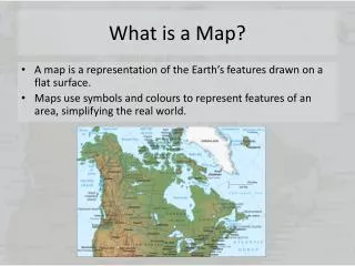
What is a Map?
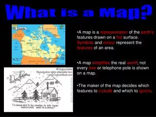
What is a Map?. A map is a representation of the earth's features drawn on a flat surface. Symbols and colour represent the features of an area. A map simplifies the real world ; not every tree or telephone pole is shown on a map.

What is a Map?
E N D
Presentation Transcript
What is a Map? A map is a representation of the earth's features drawn on a flat surface. Symbols and colour represent the features of an area. A map simplifies the real world; not every tree or telephone pole is shown on a map. The maker of the map decides which features to include and which to ignore.
There are many types of maps. Geographers can classify them into three main categories: • 1. General Purpose Maps • Give a broad understanding about the, landscape, the location of cities and towns, and the location of major transportation routes all at once. • Most maps (e.g., road maps) • 2. Thematic Maps • Maps designed to show information on one particular topic. • Easy to understand. • e.g., Vegetation Regions Map of Canada • 3. Topographic Maps • Use symbols to show a variety of features. • If you want to examine the characteristics of a small area these maps are useful. • e.g., City Map, Park Map
Locating Places on a Map • Direction • 2. Alphanumeric Grid • 3. Latitude & Longitude • 4. Map Scale
Which way is up? All complete maps identify North, making it possible for the map user to correctly orient the map. A simple way to show direction is the Compass Rose. Map Direction
North, East, South and West are considered the most important points on the compass. They are called the CARDINAL POINTS. The points in-between the 4 cardinal directions are called the ORDINAL POINTS (NE, SE, SW, NW) BEARINGS are more specific as they are measured in degrees. There are 360° on a compass. Do you know a mnemonic to help you remember the position of the cardinal points? http://www.southmagneticpole.org.au/Compass%20Rose.JPG The Compass Rose
The alphanumeric grid uses letters and numbers to identify squares in a grid pattern. e.g., B3 alpha = letters numeric = numbers An alphanumeric grid is often used on road maps. Grid squares are identified by a letter on one side of the map and a number on the other. An alphanumeric grid provides the reader of the map with a generallocation (i.e., the feature you are looking for is somewhere within the small square). Alphanumeric Grid
Let’s practice… The Cat- A3 The Frog- B1 The Penguin- A2 The Mouse- B4
Any location on Earth is described by two numbers – its latitude and its longitude. Who uses latitude and longitude “coordinates”? Pilot Captain of a Ship GPS (Global Positioning System) Why use lat/long? It gives you a specific location on Earth. The lat/long coordinates of any location on Earth will always be the same; it does not matter what map you are using. Latitude and Longitude
On a globe of the Earth, lines of latitude (“parallels”) are imaginary circles of different size. The starting point is the longest line called the equator, whose latitude is 0° latitude. The equator also divides the earth into two equal parts:1) Northern Hemisphere2) Southern Hemisphere Latitude is measured in degrees North and South of the equator. The North Pole is 90°N and the South Pole is 90°S. Latitude Northern Hemisphere Southern Hemisphere
Areas closer to the equator receive moredirect sunlight,therefore, a warmer climate. Areas further away from the equator have less direct sunlight, therefore, a colder climate. This explains why Canadians typically go south for vacations. For example, Florida is much closer to the equator than we are in Mississauga. Why is latitude important?
On the globe, imaginary lines of constant longitude ("meridians") extend from pole to pole, like the segment boundaries on a peeled orange. The starting point is called the Prime Meridian (AKA Greenwich Meridian), whose longitude is 0° longitude. The prime meridian also divides the earth into two complete halves:1) Western Hemisphere2) Eastern Hemisphere Longitude is measured in degrees East and West of the Prime Meridian (Greenwich Meridian). The International Date Line is at the 180° meridian (i.e., 180°E/W is the maximum degree of longitude). Longitude Western Hemisphere Eastern Hemisphere Every meridian must cross the equator. Since the equator is a circle, we can divide it – like any circle – into 360 degrees.
The world is divided into 24 different time zones. An hour is added every 15 degrees East of the Prime Meridian and an hour is lost every 15 degrees West of the Prime Meridian. Why is longitude important?
Let’s practice… A B D F E C A 60°N 120°W B ____________________ C ____________________ D ____________________ E ____________________ F ____________________
Map Scale Actual Ferrari Car Model Ferrari Car • Every part of the model is in true proportion to the life-size object. • A mapis a “model” of the earth. Therefore, this reduction is the • basis for scale.
Large Scale Maps show a LARGE amount of detail over a small area useful for hiking, military scouting, residential planning, theme park, conservation areas Small Scale Maps show a SMALL amount of detail over a large area used for political and physical maps Map Scale A map can either be a LARGE scale map or SMALL scale map.
Map Scale There are 3 types of scales that can be used on a map. • Direct Statement • 1 cm to 5km • Linear Scale • 0 5 10 15 20 km • Representative Fraction (RF) • 1:500 000
Let’s practice… • What is the actual distance from… • 1. Toronto, ON to Ottawa, • ON? • 2. Halifax, NS to • Charlottetown, PEI? • Winnipeg, MAN to • Victoria, BC? • Whitehorse, NWT to • Iqaluit, NUN?