Download
1 / 11
150 likes | 398 Views
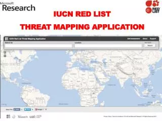
IUCN Red List Threat Mapping Application. Red List Threat mapping Application. The IUCN, in collaboration with the Microsoft Research, is developing a web application that will allow experts to not only capture threat information but also to map it spatially .

E N D
Red List Threat mapping Application • The IUCN, in collaboration with the Microsoft Research, is developing a web application that will allow experts to not only capture threat information but also to map it spatially. • The objective of this application is to develop a global threat dataset based on experts knowledge of localized threats that assists not only in the Red Listing process but also provides a global evolving database on stresses to biodiversity. Knipowitschiamrakovcici is only found in Lake Visovac, Croatia. The population is experiencing a massif decline, but the reasons for this decline are not fully understood. Pollution from nearby towns is a potential threat. This freshwater fish is currently listed as Critically Endangered. Image courtesy: IUCN & JörgFreyhof
An Overly simplistic view ofthe red listing process • Collect data on a species (range, population trends, etc.) • Collect data on threats to a species (hunting, habitat loss, etc.) • Collect data on the positive interventions related to a species (protected areas, legislation, etc.) Pico de El Sauzal (Lotus maculatus) is endemic to the island of Tenerife, the Canary Islands, Spain. It has been estimated that less than 50 individuals of this species remain. The main threats are trampling, collection, predation, and other human generated impacts. It was assessed as Critically Endangered. Image Courtesy: IUCN & A. Santos
Moving data collection forward • Collect data on the species (range, population trends, etc.) • Collect data on threats to the species (?, hunting, habitat loss, etc.) • Collect data on the positive interventions related to the species (protected areas, legislation, etc.) • Why is the ? a problem?… • Individual perception of data / situation differs from person to person. • Miscommunication or lack of communication between experts. • Difference in standards and measurement units lead to anomalies in data collected and analysed. • Human induced error and technical errors occurring during digitization process of the data. • So can we build an application to take advantage of IUCN’s massive network and close the loop? Pico de El Sauzal (Lotus maculatus) is endemic to the island of Tenerife, the Canary Islands, Spain. It has been estimated that less than 50 individuals of this species remain. The main threats are trampling, collection, predation, and other human generated impacts. It was assessed as Critically Endangered. Image Courtesy: IUCN & A. Santos
Case Study Threat: excessive hunting Location: Kabo Forest Concession in N. DRC Species: Cephalophuscallipygus (Peter’s Duiker) Recording a Threat Choose to enter a new Threat 2) Name your threat name
Provide threat category from IUCN Threat Classification Scheme Provide additional information (timing, etc.) Provide supporting media files (images, pdfs,…) Save (Or…)
Tag ‘Impacted’ Species Then save
You can now search and find that threat again You can now search for that species and it will be linked to that threat … so can someoneelse! And they could tag it to a new species that they know about…
There is a lot more functionality that I’m not showing, things like predictive search, ‘iterative search’, protected areas and other interventions, ranking of results by fraction spatial overlap…
Threat mapping application demoSpecies PavilionTuesday 11th15:30 – 16:30Interactive DiscussionCome demo the application and tell us what you want to see it do!
Residential and commercial development • 1.1. Housing and urban areas • ( e.g. Urban Areas, Suburbs, Villages, Vacation homes, Shopping areas, Offices, Schools, Hospitals ) • 1.2. Commercial and industrial areas • ( e.g. Manufacturing plants, Shopping centres, Office parks, Military bases, Power plants, Train and ship yards, Airports ) • 1.3. Tourism and recreation areas • ( e.g. Ski areas, Golf courses, Beach resorts, Cricket fields, County parks, Campgrounds ) • Agriculture and Aquaculture • 2.1. Annual and perennial non-timber crops • 2.1.1. Shifting Agriculture • 2.1.2. Small-holder farming • 2.1.3. Agro-industry farming • 2.1.4. Scale unknown / unrecorded • 2.2. Wood and pulp plantations • 2.2.1. Small holder plantations • 2.2.2. Agro-industry plantations • 2.2.3. Scale unknown / unrecorded • 2.3. Livestock Farming and ranching • 2.3.1. Nomadic grazing • 2.3.2. Small-holder grazing, ranching or farming • 2.3.3. Agro-industry grazing, ranching or farming • 2.3.4. Scale unknown / unrecorded • 2.4. Marine and freshwater aquaculture • 2.4.1. Subsistence / Artisinal aquaculture • 2.4.2. Industrial aquaculture • 2.4.2. Scale unknown / unrecorded IUCNThreat classification Main Categories • Residential and commercial development. • Agriculture and aquaculture. • Energy production and mining. • Transportation and service corridors. • Biological resource use • Human intrusions and disturbance. • Natural system modifications. • Invasive and other problematic species. • Pollution. • Geological events. • Climate change and severe weather.