Tidal Channel Cross-Section Survey Methods
Learn how to measure and analyze tidal channel cross-sections for studying geomorphological changes over time. Detailed field methods, equipment needed, data entry, and analysis techniques provided.

Tidal Channel Cross-Section Survey Methods
E N D
Presentation Transcript
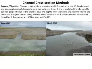
Channel Cross-section Methods Purpose/Objective: Channel cross-sections provide useful information on the 3D development and geomorphological changes to tidal channels over time. A line is stretched from bankfull to bankfull perpendicular to the channel flow, and depths from the line to the channel bottom are measured every 0.5 meters along the line. Measurements can also be made with a laser level (Hood 2010, Roegner et al. 2008) or with an RTK GPS. August 2009 March 2010 Photos by Jesse Barham
Field Methods Equipment Needed: 2 – 4 to 5 foot lengths of 1.5“ PVC Rubber Mallet or Hammer 2 – Wooden stake Flagging Long line Torpedo line leveler Measuring Tape Measuring Stick Data Book GPS Waders If needed: boat and life vests Laser level (optional) RTK GPS (optional)
Field Methods – Determine bankfull of channel and add 5 meters to each side Tl. Channel width 5 m to Endpoint Marker XS West Marker XS East Marker
Field Methods – stretch level line and measuring tape across channel XS West Marker Level Line XS East Marker
Field Methods – measure distance from channel bed to level line every 0.5 meters XS West Marker Level Line XS East Marker Measure distance from level line to channel bed
Field Methods – measure total width of channel Tl. Channel width XS West Marker XS East Marker
Field Methods – survey top of each endpoint marker so data can be converted to elevation
Field Methods Option 2. - measure channel cross-section using laser level (Hood 2010, Roegner et al. 2008) Photo from Roegner et al. 2008
Field Methods Option 3. - measure channel cross-section with RTK GPS
Data Entry and Analysis: Channel development (i.e. scour or fill) is determined by comparing measurements at channel cross sections over time.
For a detailed, pdf version of these methods, use the links on the right to download the Channel Cross-section SOP , Datasheet and Database Template. • References: • Hood W. G. 2010. Tidal channel meander formation by depositional rather than erosional processes: examples from the prograding Skagit River Delta. Earth Surface Processes and Landforms 35: 319 – 330. • Roegner, G.C., H.L. Diefenderfer, A.B. Borde, R.M. Thom, E.M. Dawley, A.H. Whiting, S.A. Zimmerman, and G.E. Johnson. 2008. Protocols for Monitoring Habitat RestorationProjects in the Lower Columbia River and Estuary. PNNL-15793. Report by Pacific Northwest National Laboratory, National Marine Fisheries Service, and Columbia River Estuary Study Taskforce submitted to the U.S. Army Corps of Engineers, Portland District, Portland, Oregon.