Download
1 / 34
340 likes | 380 Views
Dive into the features of Google Maps & Earth for educational use in parks, including Street View and marker customization.

E N D
Derek Hughes Tuesday, July 12, 2016 Google Earth and Google MAPSNPS Webinar
Briefly introduce yourself – name, your park/office, and position Introductions
Google Maps to get to Google Maps go to Google and click on the maps link or log into your Gmail account Basic Program Features of Google Maps and Earth
Icons in the bottom right corner Street view Street view can be used to get a photographic view of a place – photos viewed can be submitted by others to Google Maps To use SV you must click on the icon and you can drag the person to any spot on the map and double click to view photo(s) Google Maps - icons
Once you click on an area to view the photo you can also get a panoramic view depending on the way the photograph was taken You may also select other related images that have been upload in a similar fashion Once finished you can click on the link in the bottom left hand corner titled return to map Street View continued
The upside to this tool is that you can see panoramic views of places that represent your park The upside Provides interactive visual aids for visitors and students to your park This allows for the opportunities to utilize higher level thinking techniques while addressing multiple learning styles. This also allows you to reinforce content from previous lessons taught by classroom teachers. These topics will be discussed later in the presentation. Street View and other viewing on Google Maps
The downside The photos uploaded are the product of who took and/or posted them. Street View and other viewing on Google Maps
When you click on the yellow man icon you can also get a small menu that offers other options including Aside from streetview you can view “photo sphere” and “see inside” When you click on “photo sphere” it gives you instant access to a photograph (sometimes panoramic) like with street view. The difference is that streetview can be clicked anywhere but “photo sphere” is only where photos have been posted. More from the yellow man icon
Using the “photo sphere” option can allow you to control what photos you post from a map created for your specific park – creating you own maps will be addressed later The other option is the “see inside” option When you click on this option again it is subject to the photos posted but lets a viewer see inside a building for a more interactive view More from the yellow man icon
The benefits of “see inside” could be used to highlight or provide previews of buildings at your park including a welcome center, book store, museum, etc. It is also dependent on the photographs that you would take and how you take/post them to your own map. This would give you control with what and how it is viewed. This also allows you to further control what desired outcome from having the interactive inside view. “see inside”
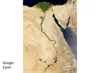
This allows you to view aerial maps. Chesapeake & Ohio Canal National Historical Park This allows you to also have the same visual options as the Google Maps view discussed previously. There is also the option for a 3D view which enhances the quality of the visuals. Satellite view
You can customize your own maps and save them. Once you log into your gmail account, you search Google Maps and click on My Maps. Your saved maps will appear. These maps can be shared with links to others for viewing and educational opportunities. My Maps option
Here are directions for our to place your own markers and how to post your own descriptions. Step 1 – go to a map of your park Step 2 – place two markers and post two descriptions Step 3 – if possible post at least one photograph to your map Now take the time to create your own Map
Setup • In the panel to the left of the screen, click My Maps, then click the Getstarted button. • If you already have a Google account, sign in.If not, click to create a new account. Creating your own Map
Click Create New Map. Note: If you have just signed up, you will be automatically taken to the next screen. • Enter a Title for the map. Include your name in the title. • Enter a Description of your project. • In the Privacy and sharing settings section, click Unlisted. (Your map will be shared only with people to whom you give the URL of your map.) Creating Your own Map
Mark a Point of Interest • Pan, zoom, and adjust the view of the map, to find a specific view of your chosen geographical feature, monument, building, etc - that demonstrates – or provides clues about – one aspect of your park • Record your observation and description of chosen topic • At the top of the page under the search bar is a series of buttons • Choose the little gray marker icon similar to the one shown except yours is all gray Creating your own map
Now click at an appropriate point on the map.The icon will bounce into place.Your Observation and Inference • In the Title box, type in a title • In the Description box, type an entry that includes: • The view (Satellite, Map, or Terrain) • The zoom level • Your observation and description • You can also choose the edit button later to fix or make changes Creating your own Map
Optional: Add a Photo to a Placemarker • Locate a relevant photo that you can legally share. • To add the photo to the information window of a placemarker click the camera icon that looks similar to the one below. Adding a photo to your map
It is important to understand that you are not referencing thepage on which the photo is published – you need to find the URL of the photo itself. There are various ways – even within one Web application – in which Web sites make this information available. You must be prepared to experiment to find out the way that works for each situation Adding a photo to your map
To the left of your map there will be a box with all of your points. There will be an person icon with the option to share. Clicking on this will allow you to choose how you want to share your map and how it will be viewed. You can choose who has access – there can be a general view by people or you can add specific email addresses. I recommend you only share with people who are given the links. You can copy and paste the link at the top of the box to share your map. You must choose to let people only with the link first below sending them the link or they will not be able to view it. Share Your Map
Please provide a brief description of the map you created and what you included. Post your answers in blue. Please also send and share your map with another person in the class. This will provide a good way to collaborate and discuss options with another colleague. Tell us about your map
Two examples Inference Activity Webquest Activity Educational Possibilities – Advanced Lessons
This activity is one that I use with my students to practice their analysis of maps. I copied student inferences into the comments point marked on the map. Students examine the details of the chosen map prior to and/or after classroom lessons on the chosen area. It can also provide a way to synthesis information learned to develop more detailed inferences. Inference Activity
This activity asks students to use various websites to answer questions, make inferences, analyze primary and secondary sources (articles, maps, charts, etc). Students go to websites of selected National Parks to gather information. The desired outcome(s) will shape what information they use and how they use it. In one web quest students use information from inferences and class lessons to further study the importance of canals in early American History. Web quest Activity
This program requires you to download the app which allows you to use it (free). This comes with two options Google Earth and Google Earth Pro – free trial or pay for license use Options include Searching for specific places by using the search bar – by plugging in the address it will zoom in directly to the place you wanted to view Google Earth
There is also a new street view option. It is best used after you have selected a specific location and put the address in the search bar in the top left corner. You can also view panoramic views, landscapes, 3D buildings, photographs, etc. It offers similar interactive capabilities as Google Maps. It also allows easy identification, examination, comparison, and study of topics of interest including National Historical Parks, National Forests, etc. Google Earth
After you log into Google Earth with a Gmail account you can save locations in Google Earth like in Google Maps. You can also see panoramic 3D video clips – gives a 360 degree examination of selected topics Examples -Old Faithful – Yellowstone National Park - USS Arizona Memorial Google Earth Examples
Take a minute and think of one aspect, characteristic, monument, etc that represents your park the best. Share and discuss Take 1-2 minutes to list three ways that you think you could use Google Maps and Earth based on what was discussed. What did you come up with? Basic Uses of Google Maps and Earth
History ex: The Tule Lake Unit, WWII Valor in the Pacific National Monument ex: James A Garfield National Historic Site ex: Chesapeake and Ohio Canal National Historical Park Ex: George Washington Carver National Monument Science ex: Old Faithful – geysers, geothermal energy, Yellowstone Caldera ex: Conservation – activities could be developed to incorporate multiple academic disciplines such as biology, environmentalism, and history -Channel Islands National Park -Dinosaur National Monument - Petrogplyphs Math ex: distance tool – this is the little ruler icon below search bar English/Writing and Analytical Thinking ex: Sample Inferences Activity – Harpers Ferry, WV Educational Possibilities of Google Maps and Earth
Ideas for future programming Programs and curriculum Strengthen education programs Geology with Google Maps/Earth How to interpret and tell stories through maps/how to include Google Earth, Maps, and tours to park website How to use Google Earth and Maps to enhance our distance learning abilities Topics of Interest
Does anyone have any questions? Q & A Time
If you have further questions dealing with specifics related to your particular national park If you would like help with developing or reviewing curriculum Feel free to contact me Derek Hughes 304-839-9910 dhughes@k12.wv.us Thank you for your time
Enhancing Student Learning on Visits to National Parks Please join us on Tuesday, July 26, 2016 starting at 2:00 This webinar will examine how through the use of various methodologies and analysis techniques used by historians and history teachers, the workable knowledge learned by students on visits to historical national parks can be amplified. It can also compliment the strategies and lessons students learn in their classrooms (and what was mentioned today). The result is potentially greater connections made between the lessons in the classroom and lessons learned on visits to a national park to maximize student education. Reminder
https://www.nps.gov/tule/index.htm https://www.nps.gov/jaga/index.htm https://www.nps.gov/choh/index.htm https://www.nps.gov/gwca/index.htm https://www.nps.gov/yell/index.htm https://www.nps.gov/chis/index.htm https://www.nps.gov/dino/index.htm https://www.nps.gov/hafe/index.htm Park Websites