Download
1 / 13
130 likes | 152 Views
Presentation on the Earth System Science Organisation (ESSO) and its mission to excel in knowledge and technology for the benefit of the Indian sub-continent and the Indian Ocean region. Discusses ESSO's contributions to satellite sensors, acquisition and processing of ocean and atmospheric variables, calibration and validation, and utilization of satellite-derived information for societal needs.

E N D
ESSO Linkages with EOS Ministry of Earth Sciences, India Presentation to the 26th CEOS Plenary at Bengaluru, India 24-27 October, 2012
ESSO • Earth System Science Organisation (ESSO) formed in 2006 to bring Ocean & atmosphere Departments of Government of India under one umbrella • Vision To excel as knowledge and technology enterprise for the earth system science realm towards socio-economic benefit of the Indian sub-continent and in the Indian Ocean region. • Mission • Promote scientific research in Earth System sciences as a whole comprising the atmosphere, hydrosphere, cryosphere and the geosphere. • Provide the best possible Information services to various sectors including early warnings to natural disasters like storm surge, earthquakes, tsunamis • Conduct ocean survey and develop technology for exploration and exploitation of ocean resources (living and non-living), ensuring their sustainable utilization The 26th CEOS Plenary – Bengaluru, India - 24-27 October, 2012
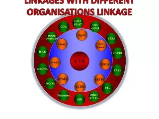
ESSO Earth Commission Ministry of Earth Sciences Earth System Science Organization National Centre for Seismology India Meteorological Department Centre for Marine Living Resources and Ecology National Centre for Medium Range Weather Forecasting Indian Institute of Tropical Meteorology Centre for Climate Research National Centre for Antarctic and Ocean Research Advanced Training in Earth System Science and Climate Integrated Coastal and Marine Area Management National Institute of Ocean Technology Indian National Centre for Ocean Information Services
Relevance of ESSO in EOS • Contribute in defining satellite sensors for Earth System Sciences • Acquisition and processing of ocean and atmospheric variables • Calibration and Validation • Utilization of satellite derived information to societal needs The 26th CEOS Plenary – Bengaluru, India - 24-27 October, 2012
Contribute in defining satellite sensors Satellites Payload for Ocean & Atmosphere • Ocean Color • Scatterometer • Assimilate in Atmospheric model • Forcing the Ocean model • INSAT • Wind Profilers from Space? • Vertical resolution ~ 1 km upto 13 km • Horizontal resolution ~ 10 km • Accuracy ~ 1 m/s The 26th CEOS Plenary – Bengaluru, India - 24-27 October, 2012
Acquisition & Processing of satellite data • Maintaining two satellite ground stations on operational basis : a) Atmospheric studies (INSAT, KALPANA, MODIS, ….) b) Ocean studies (OCEANSAT-2, MODIS, NOAA series, METOP, …) • Information processing, satellite data ingestion, value added product generation and archival. • Availability of products on near real time. • Established direct data access with NOAA-NESDIS and ISRO along with reception facility for EUMETCAST broadcast. • Setting up of Polar orbiting satellite data reception station at the Larsmann Hills, Antarctica The 26th CEOS Plenary – Bengaluru, India - 24-27 October, 2012
CALVAL • Parameters and Satellites for Ocean information • IR and MW SSTs (AVHRR, MODIS, TMI, AMSR-E, WindSAT, …) • Diffuse atten. & Chl-A (SEAWIFS, MODIS, OCEANSAT,..) • 10-m wind speed (SSM/Is, TMI, AMSR-E) • 10-m wind vectors (QuikSCAT, WindSAT and MetOp /ASCAT, OCEANSAT) • SSH (Jason-1 & 2,T/P, ERS-2) Calibration and Validation • Ocean parameters • In-situ observing systems • Argo – SMOS/Aquarius, Altimeters, • Moorings – Scatterometers, Radiometers, • Tide gauges – Altimeters • CALVAL buoys – Ocean color • Coastal HF Radar, 5 Research vessels, …… • SATCORE project (calibration of ocean color) The 26th CEOS Plenary – Bengaluru, India - 24-27 October, 2012
CALVAL Calibration and Validation • Atmospheric parameters • In-situ observing systems • A radiometrically stable land based cal-val site for INSAT-3D is in the process of commissioning. • Radiosonde • AWS • Doppler Radars • Validation of satellite derived winds, SST, sea level, Chlorophyll-a, etc • Generation of Climate Data Record The 26th CEOS Plenary – Bengaluru, India - 24-27 October, 2012
CALVAL Calibration & Validation • Percentage of Kalpana-1 and NOAA OLR matched in regular bins of 5 Wm-2. The lower panel shows number of values in each bin. Daily averaged OLR for the period May 2004 – June 2012 were considered for comparison The 26th CEOS Plenary – Bengaluru, India - 24-27 October, 2012
District level Agro-met advisories • Bi-weekly Agro-met Advisory Bulletins (550 districts) based on Multi-model Ensemble (Rainfall, Max and Min temp. , Total cloud cover, Surface Relative humidity & Wind). Accuracy: 70-75 %. • State and national level composite advisories • Advisories at block level is on the way. • Dissemination: Print, Radio, TV, Web, Mobile. 30,00,000 farmers use mobiles. 24% farmers are using the advisories. • Contributions to National GDP Rs 50,000 crores (10 billion US$) The 26th CEOS Plenary – Bengaluru, India - 24-27 October, 2012
Stages to reach Grass Roots &Benefits of PFZ PFZ Generation Dissemination • SST(AVHRR/MODIS Aqua/GHRSST) • Chlorophyll-a (MODIS / Oceansat) • Wind Speed and Direction (ECMWF / Oceansat 2) Increased User Base • Telephone / Fax • Electronic Display Boards • E-mail • Web with WebGIS • Radio & Doordarshan • Mobile • Local News Papers • Information Kiosks User Interaction/ Feedback Validation • User Interaction Programmes • Awareness Campaigns • Training Programmes • Feedback Collection Meetings Executive Summary of NCAER • Controlled Validation Experiments • Collection of Landings Data • Cost-Benefit Analysis • Net Profits • Total Annual Net income due to PFZ: `34,000 to ` 50,000 Crore • The economic benefits resulting from identification of PFZs to estimate the National GDP • Mechanized Crafts: up to 1.47% - 1.65% • Mechanized and Motorized: up to 1.58 to 2 % • Mechanized, Motorised and Traditional Crafts: Around 2.04% Satellite Launch for 04 years period provides a huge economic and environment (reduction in burning of more fossil oils) benefits to the country The 26th CEOS Plenary – Bengaluru, India - 24-27 October, 2012
Our request • ESSO is a Government Organization, which significantly contribute to defining, calibration /validation, utilization of EOS data for the societal applications. • Considering ESSO contribution to (i) Ground segment activity and (ii) Programmatic activity that supports CEOS objectives, We request to consider ESSO as an Associate member of CEOS • ESSO can contribute to (i) SBA teams (climate, weather, agriculture, water…), (ii) WG (climate, CALVAL, ..) and (iii) Virtual constellations (ocean and atmosphere) The 26th CEOS Plenary – Bengaluru, India - 24-27 October, 2012
ESSO and CEOS Thank you for your kind attention The 26th CEOS Plenary – Bengaluru, India - 24-27 October, 2012