Download
1 / 1
10 likes | 249 Views
Using Sonar and Digital Imagery To Estimate Crop Biomass. Carol Jones Advisor: Dr. Marvin Stone. Oklahoma State University Biosystems and Agricultural Engineering. Introduction Sonar: may be used to detect proximity and distance in machine vision (Senix 2003)

E N D
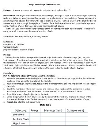
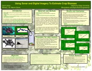
Using Sonar and Digital Imagery To Estimate Crop Biomass Carol JonesAdvisor: Dr. Marvin Stone Oklahoma State UniversityBiosystems and Agricultural Engineering Introduction • Sonar: may be used to detect proximity and distance in machine vision (Senix 2003) • Digital imagery: may be used to estimate vegetative coverage (Lukina et al 1999) • Combination of sonar and digital imagery:can it be used to estimate plant biomass in spinach? The combination of sonar response and digital imaging analysis integrated into a procedure to accurately estimate plant biomass may facilitate more accurateharvestingand chemical application decisions. The procedure may be incorporated into machine vision based variable rate application technology and may also be used to studygeneral plant health. Materials and Methods • Sonar Unit: Senix Ultrasensor SPA • Digital imagery: DuncanTech MS3100 multispectral camera • Turntable and greenhouse grown spinach plants The sonar unit was suspended over a turntable using a fixed mount arm. Plants were placed on the turntable rotating at 10 ft/min for sensing. Sonar response was recorded and compared to hand rule measurements taken every inch through the profile of the plant. The sonar unit emitted and received ultrasound waves at 50 kHz. Three data points per second were recorded by a laptop computer using proprietary software. The data were imported into statistical analysis software. The multispectral camera was tripod-mounted at NADIR to provide images of the horizontal plane of the plants. These digital images were analyzed using Matlab and Adobe Photoshop to provide a plant surface area estimate. Hypothesis equation: Results and Conclusions • Sonar-Camera estimated biomass correlated with actual biomass (r2=0.92) • Sonar may be used to accurately estimate plant height (r2=0.87) • Estimated plant height may improve the estimate of plant biomass when combined with digital camera vegetative coverage data (improved from r2=0.31 to r2=0.92) • On single plant basis: NDVI correlates with chlorophyll concentration (r2=0.78) • Given: (chlorophyll concentration)(biomass) = chlorophyll content, does (NDVI)(estimated biomass) have a strong correlation to laboratory measured chlorophyll content? Results: (NDVI)(plant surface area) vs. chlorophyll content…r2=0.72 (NDVI)(plant surface area)(height) vs. chlorophyll content… r2=0.99 SONAR Multispectral digital image of spinach Plant profile generated by sonar Procedure for data analysis: • Combine sonar-camera biomass estimation with normalized difference vegetative index (NDVI) to estimate chlorophyll content in spinach on a per plant scale. NDVI was determined using multispectral camera images. (Gitelson 2002, Weckler et al 2003, Ter-Mikaelian 2000, Raun et al 1998) Camera filters: 780 and 670 nm • Compare to laboratory chlorophyll analysis (Inskeep 1985) to determine correlation • Compare chlorophyll content estimation with surface area only to chlorophyll content estimation using surface area and height data. Does height sensing improve the estimate? 42” Threshold image Histogram of threshold image References Gitelson, A. A., M. Merzlyak (2002). Non-destructive assessment of chlorophyll, carotenoid and anthocyanin content in higher plant leaves: principles and algorithms. Remote Sensing for Agriculture and Environment, Kiffisia, Greece, Organization for Economic Cooperation and Development. Inskeep, W. P. and. P. R. Bloom (1985). "Extinction coefficients of chlorophyll a and b in N, N-dimethylformamide and 80% Acetone." Plant Physiology 77: 483-485. Lukina, E. V., M. L. Stone, and W. R. Raun (1999). "Estimating Vegetation Coverage in Wheat Using Digital Images." J. Plant Nutr. 22(2): 341-350. Raun, W. R., G.V. Johnson, H. Sembiring, E.V. Lukina, J.M. LaRuffa, W.E. Thomason, S.B. Phillips, J.B. Solie, M.L. Stone and R.W. Whitney (1998). "Indirect measure of plant nutrients." Commun. In Soil Sci. Plant Anal. 29: 1571-1581. Senix Corp. (2003). "Senix Technology."http://www.senix.com/technolo.htm. Accessed November 21, 2003. Ter-Mikaelian, M. T. and W.C. Parker (2000). "Estimating biomass of white spruce seedlings with vertical photo imagery." New Forests 20: 145-162. Weckler, P. R., N.O. Maness, C.L. Jones, R. Jayasekara, M.L. Stone, D. Chrz and T. Kersten (2003). Remote Sensing to Estimate Chlorophyll ConcentrationUsing Multi-Spectral Plant Reflectance. 2003 ASAE Annual International Meeting, LasVegas, NV, Amer. Society of Ag. Engineers. Objective To determine the effectiveness of three dimensional analysis in remote sensingtoassess biomass, a method to accurately estimate biomass in spinach plants was investigatedusing sonar to provide the ”z” height dimension and digital imagery to provide the “x-y” surface area dimension. Future Research • Repeat biomass estimation study on spinach to provide robust statistical analysis. • Expand biomass estimation project to include two crops with different leaf structures such as corn and snap pea. • Expand spinach research to include field testing of chlorophyll content and concentration estimation using sonar for height measurement. Technical Support Acknowledgements: Dr. Niels Maness, Roshani Jayasekara, Wayne Kiner and the BAE Laboratory Staff, Dr. Paul Weckler Project funded by USDA/CSREES