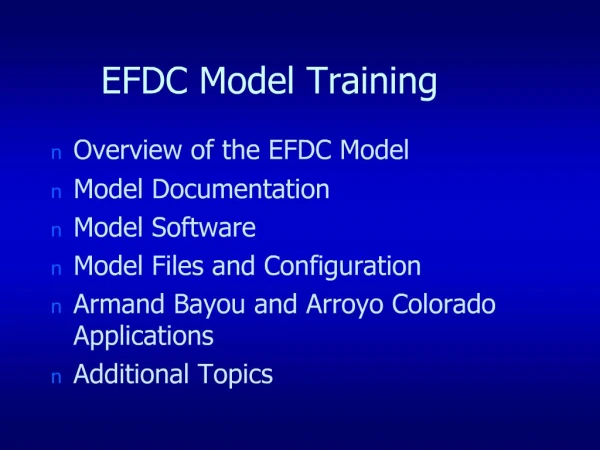
EFDC Model Training
EFDC OVERVIEW. Development HistoryCapabilitiesHydrodynamicsWater Quality-EutrophicationSediment-Toxic Transport and FateNear Field MixingPrevious ApplicationsWater Quality Application. ENVIRONMENTAL FLUID DYNAMICS CODE. The EFDC Model Is a Public Domain Surface Water Modeling SystemIncorpora

EFDC Model Training
E N D
Presentation Transcript
1. EFDC Model Training Overview of the EFDC Model
Model Documentation
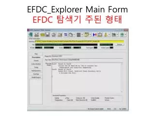
Model Software
Model Files and Configuration
Armand Bayou and Arroyo Colorado Applications
Additional Topics
2. EFDC OVERVIEW Development History
Capabilities
Hydrodynamics
Water Quality-Eutrophication
Sediment-Toxic Transport and Fate
Near Field Mixing
Previous Applications
Water Quality Application
3. ENVIRONMENTAL FLUID DYNAMICS CODE The EFDC Model Is a Public Domain Surface Water Modeling System Incorporating Fully Integrated Hydrodynamic, Water Quality and Sediment-Contaminant Simulation Capabilities
EFDC Is Extremely Versatile and Can Be Used for 1, 2, or 3-Dimensional Simulation of Rivers, Lakes, Estuaries, Coastal Regions and Wetlands
The Single Source Code Implementation Eliminates the Need for Linking Multiple Models to Arrive at an Effective Modeling Solution
4. EFDC DEVELOPMENT HISTORY Developed at Virginia Institute of Marine Science with Primary Support from State of Virginia
Additional Support from EPA and NOAA
Presently Maintained by Tetra Tech, Inc.
Currently used by Federal, State and Local Agencies, Consultants and Universities
US EPA Currently Supporting Development of EFDC-Based Surface Water Modeling Toolkit
5. EFDC CAPABILITIES Three-Dimensional Hydrodynamics with Coupled Salinity and Temperature Transport
Directly Coupled Water Quality-Eutrophication Model
Directly Coupled Toxic Contaminated Sediment Transport and Fate Model
Integrated Near-field Mixing Zone Model
Preprocessing Software for Grid Generation and Input File Creation
Postprocessing Software for Analysis, Graphic and Visualization
7. EFDC HYDRODYNAMICS Fully Three-Dimensional with 2-D and 1-D Options
Boundary Fitted Curvilinear Grid
Includes Turbulence Closure Model
Highly Efficient Semi-Implicit Solution
Functionally Equivalent to POM/ECOM CH3D-WES and TRIMM
9. Additional Hydro Capabilities 1-D Channel Network Option Using HEC Type Cross Section Data
Hydraulic Control Structures
Wave Boundary Layers and Wave Induced Currents
10. EFDC WATER QUALITY-EUTROPHICATION Directly Coupled to Hydrodynamics
Based on CE-QUAL-IC (Chesapeake Bay WQ Model) Kinetics
21 Water Column State Variables Including Multiple Classes of Algae and Organic Carbon, Nitrogen and Phosphorous
Includes 27 State Variable Sediment Diagenesis Sub-model
Reduced Number of State Variable Version Equivalent to WASP5
12. EFDC WQ State Variables 1) cyanobacteria
2) diatom algae
3) green algae
4) refractory particulate organic carbon
5) labile particulate organic carbon
6) dissolved carbon
7) refractory part. organic phosphorus
8) labile particulate organic phosphorus
9) dissolved organic phosphorus
10) total phosphate
11) refractory part. organic nitrogen 12) labile part. organic nitrogen
13) dissolved organic nitrogen
14) ammonia nitrogen
15) nitrate nitrogen
16) particulate biogenic silica
17) dissolved available silica
18) chemical oxygen demand
19) dissolved oxygen
20) total active metal
21) fecal coliform bacteria
22) macroalgae
13. EFDC Water Quality Schematic
14. EFDC SEDIMENT DIAGENESIS MODEL Developed by DiToro & Fitzpatrick for Chesapeake Bay Model
27 state variables and fluxes
Three basic processes:
Depositional flux of POM from water column
Diagenesis (decay) of POM in sediments
Flux of substances produced by diagenesis
Benthic sediments represented by 2 layers
Upper layer can be oxic or anoxic
Lower layer is always anoxic
15. Sediment DiagensisModel Schematic
16. EFDC SEDIMENT AND TOXICS TRANSPORT Multiple Size Class Cohesive and Noncohesive Sediment Transport
Includes Sediment Bed Geomechanics with Consolidation
Coupled with Spectral Wave Model for Wave Induced Resuspension
Simulates Water Column and Bed Heavy Metal and Toxic Organic Compounds
Equilibrium Partitioning and Reactions
20. EFDC NEAR-FIELD MIXING Embedded Near-field Mixing Submodel
Represents Outfalls as Buoyant Jets
Capabilities Similar to CORMIX
Updates Multiple Sources Under Varying Ambient Conditions
Directly Coupled to Far Field WQ and Sediment-Toxics Submodels
21. EFDC APPLICATIONS Rivers - Blackstone (MA), Ohio (WVA), Duwamish (WA), Christina River (DE), Yazoo River (MS), Housatonic (MA), Chattahoochee (GA)
Lakes - Lake Okeechobee (FL), Conowingo (MD), Ten Killer (OK)
Wetlands - South Florida Water Conservation Areas, Everglades Stormwater Treatment Areas
Estuaries - Chesapeake Bay, James River (VA), York River (VA), Potomac River (MD), Peconic Bay (NY), Indian River Lagoon (FL), Puget Sound, San Francisco Bay, Morro Bay (CA), Mobile Bay (AL), Neuse River (NC), Cape Fear (NC)
22. EFDC APPLICATIONS Coastal Regions - Atlantic Shelf (NC), Vero Beach (FL), Western Australian Shelf, Nan Wan Bay (Taiwan), Arabian Gulf, Wadden Sea (Germany), St. Louis Bay (MS)
23. EFDC Documentation Hydro Theory - (Hamrick, 1992)
Eutrophication Theory - (Park, 1995)
Hydro User�s Manual - (Hamrick, 1996)
Short Eutro Theory - (Tt, 1998)
Numerical Schemes - (Hamrick & Wu)
Sediment-Toxics - (Tt, 1999)
24. EFDC Software EFDC.F - F77 Source Code
EFDC.COM - Common Block Include File
EFDC.PAR - Parameter Statement Include File
25. EFDC Support Software GEFDC.F - Grid Generator
SIEFDC.F - Spatial Initialization
LSHS.F - Scalar Harmonic Analysis
LSHU.F - Vector Harmonic Analysis
BCEFDC.F - Open Boundary Condition Identification
26. EFDC Support Software ATEFDC.F - Time Series Analysis
PROCONH.F - Scalar Contouring and Images
PROVELH.F - Vector Plotting
27. EFDC Graphics Support Noesys
MATLAB
Tecplot
GRADS
28. Model Configuration Data Structure
Input Data Files
Examples
29. EFDC Data Structure Spatial Variables
A(I,J,K) -> A(L,K)
I = pseudo x
J = pseudo y
K= stretched vertical layer
L=L(I,J) single index in horizontal
30. Spatial Input Files cell.inp - cell type file
celllt.inp - auxillary cell type file
dxdy.inp - horizontal cell dimensions, depth, bottom elevation, roughness
lxly.inp - horizontal cell center coordinates and cell orientation
gcellmap.inp - graphics mapping file
33. Creating Spatial Files cell.inp - conceptualization of horizontal grid
dxdy.inp - custom, gefdc.f, or toolkit grid generator
lxly.inp - same as dxdy.inp
gcellmap.inp - gefdc.f
34. Other Spatial Files mask. inp - inserts thin barriers
mappgns.inp - specifies period grids along north-south or breaks in grid in north-south (J) direction
moddxdy.inp - modifies cell dimensions orginally specified in dxdy.inp
amap.inp & wmap.inp - atmospheric and wind map files
35. Initial Condition Files Salt.inp
temp.inp
dye.inp
sedw.inp
sndw.inp
toxw.inp
sedb.inp
sndb.inp Toxb.inp
wqwcrst.inp
wqsdrst.inp
All can be created with SIEFDC.F
36. Time Series Input Files Aser.inp - atmos.
Wser.inp - wind
qser.inp - flow
sser.inp -salt
tser.inp - temp
dser.inp - dye
sdser.inp - coh sed
snser.inp - noncoh Txser.inp - toxics
cwqsr##.inp - water quality variables
wqpsl.inp - water quality sources
Cut and Paste Creation
37. Processes Files Qctl.inp - hydraulic control structures
gwater.inp - groundwater interaction
vege.inp - vegetation resistance
wavebl.inp - wave-current boundary layers
wavesx.inp - wave induced currents
38. Run Control Files Efdc.inp - master input file
wq3dwc.inp - water quality input
wq3dsd.inp - sediment diagensis
restart.inp - hydrodynamic restart
wqwcrst.inp - water quality restart
wqsdrst.inp - sediment diagensis restart file
39. Model Setup Construct Spatial Files
Construct Time Series Files
Configure efdc.inp File
Test Hydrodynamics
Configure wq3dwc.inp and wq3dsd.inp Files
Test Water Quality
40. EFDC Output Options Full 3D Spatial Dump of Selected Variables at Specified Time Intervals
Horizontal Plane Scalar and Vector Plotting Output Files
Vertical Plane Scalar and Vector Output Files
Time Series and Grab Sample Files
41. 3D Spatial Output Files - NAM3d##.asc or NAM3d##.bin
NAM - Variable Name ie sal or uuu
asc - ascii text file
bin - binary file
output can be scaled
integer or floating point
42. Horizontal Plane Graphic XXXconh.out - scalar contouring or image generation data for variable XXX
velvech.out - vector plot data
both file are ascii column data
proconh.f and provelh.f process these file to generate sequential snapshots for importing into 2D graphics
43. Time Series Output XXXts##.out - time series of variable XXX
Can be directly plotted using xy plotting software or a spreadsheet
44. EFDC SURFACE WATER MODELING TOOLKIT Presently Under Development
WINDOWS Interface
GIS Based Data Management System
User Friendly Model Setup, Execution, and Simulation Evaluation
Will Be Compatible With BASINS
45. SurfGraphs Surface Water Modeling Graphics System
Defines Shape File for Model Cell in Horizontal and Along Vertical Slices
Model Data Output as BMD Files
Designed for Use with CE-QUAL-W2, EFDC, and WASP