Download
1 / 35
350 likes | 391 Views
Explore how MODIS data is used to retrieve cloud properties globally and regionally, with insights from the MODIS Science Team Meeting in July 2002. Learn about operational cloud products, cloud temperature, infrared cloud phase, and advancements in cloud particle size retrieval. Discover new algorithms that enhance cloud phase discrimination and surface albedo mapping, while addressing challenges like mixed-phase clouds and multilayered cloud detection.

E N D
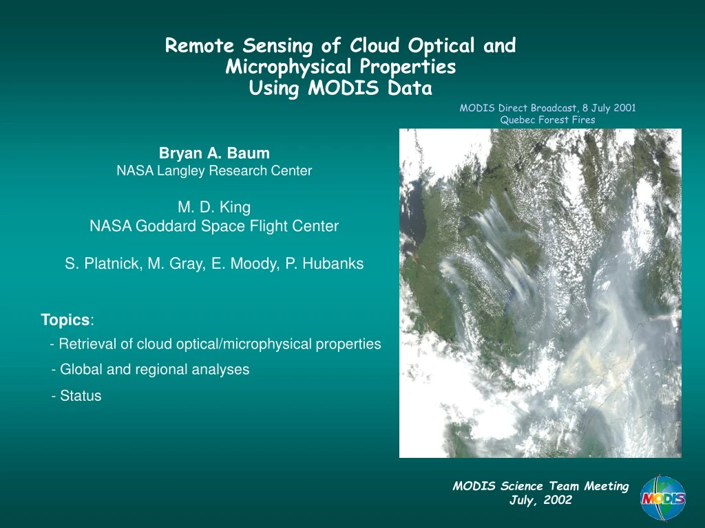
Remote Sensing of Cloud Optical and Microphysical Properties Using MODIS Data MODIS Direct Broadcast, 8 July 2001 Quebec Forest Fires Bryan A. Baum NASA Langley Research Center M. D. King NASA Goddard Space Flight Center S. Platnick, M. Gray, E. Moody, P. Hubanks Topics: - Retrieval of cloud optical/microphysical properties - Global and regional analyses - Status MODIS Science Team Meeting July, 2002
Cloud Clearing • Based on multispectral threshold tests from 17 spectral bands ranging from 0.55-13.93 µm (including new 1.38 µm band) • Consists of 48 bits of information for each pixel, including results of individual tests and the processing path used • bits 1 & 2 give combined results (confident clear, probably clear, probably cloudy, cloudy) • Cloud mask is input to rest of atmosphere, land, and ocean algorithms • Recent improvements for Version 4 (and upcoming reprocessing effort) - semi-arid land (less uncertain in clear-sky regions) - sunglint (better discrimination between low clouds and clear sky) • Provided at both 0.25 km and 1 km spatial resolution
Operational Cloud Products 18 July 2001 Platnick et al, 2002: The MODIS cloud products: Algorithms and examples from Terra. Submitted to IEEE Transactions on Geoscience and Remote Sensing (TGARSS)
Cloud Temperature 18 July 2001
Infrared Cloud Phase 18 July 2001
Daytime Multilayered Cloud Detection 18 July 2001 multilayered water Number of times a pixel was classified as being multilayered Scan line number ice clear Scatterplot for 200 x 200 pixel array Pixels are analyzed multiple times (except around edges of granule) by staggering the array over the scene Nasiri and Baum, 2002: Daytime Multilayered Cloud Detection using MODIS Data. In preparation. Pixel number across scan line
Retrieval of Optical Thickness and Particle Size(M. D. King and S. Platnick) • The reflection function of a nonabsorbing band (e.g., 0.86 µm) is primarily a function of optical thickness • The reflection function of a near-infrared absorbing band (e.g., 2.14 µm) is primarily a function of effective radius • clouds with small drops (or ice crystals) reflect more than those with large particles • For optically thick clouds, there is a near orthogonality in the retrieval of tc and re using a visible and near-infrared band Liquid Water Clouds - ocean surface
Cloud Optical & Microphysical Properties Retrieval Example Liquid Water Clouds - ocean surface Liquid Water Clouds - ice surface
Cloud Optical Thickness 18 July 2001
Cloud Particle Size 18 July 2001
Recent Improvements for Collection 4 Code Delivery New high resolution surface albedo map based on MOD43. New cloud phase decision algorithm that merges results from the IR (8.5 and 11 mm) and decision tree (based on cloud mask) approaches. Serious algorithm problems solved (polar retrievals, use of pre-calculated cloud property libraries). Large reduction in number of unsuccessful retrievals.
Ecosystem Map(A. H. Strahler, C. B. Schaaf, et al. – Boston University) MOD12 (IGBP ecosystem classification) + USGS water + tundra
Surface Albedo Surface albedo = ecosystem + MOD43 (Strahler, Schaaf et al.) aggregation
Cloud Optical Thickness in the Arctic:Provisional Production Code (edition 3) June 2, 2001 tc 20 15 10 5 0
Cloud Optical Thickness in the Arctic:Provisional Production Code (new correction) June 2, 2001 tc 20 15 10 5 0
Cloud Effective Radius in the Arctic:Provisional Production Code (edition 3) June 2, 2001 re(µm) 40 34 28 22 16 10 4
Cloud Effective Radius in the Arctic:Provisional Production Code (new correction) June 2, 2001 re(µm) 40 34 28 22 16 10 4
Global Cloud Retrievals Global cloud optical/microphysical properties being derived for both Terra and Aqua data What follows are comparisons between identical Terra and Aqua cloud parameters for July 4, 2002.
Summary of Cloud Optical and Microphysical Property Products Comparison of prelimary Aqua products to Terra products shows remarkable consistency and is thus encouraging. Many improvements have been implemented for retrievals of cloud optical thickness and particle size. Major improvements include: - polar regions - cloud phase - fewer unsuccessful retrievals - use of MOD43 to improve characterization of multispectral surface reflectances Highest priorities are 1. Mixed-phase clouds 2. Multilayered clouds 3. Better cloud phase discrimination
Cloud Particle Size Comparison Difference in particle effective radius (microns) relative to a retrieval using the 2.1 mm band. In general, the left panel shows similar sized or smaller liquid water radii when using the 1.6 mm band in place of the 2.1 mm band, in contrast to larger radii with the 3.7 mm band.