Download
1 / 43
640 likes | 1.73k Views
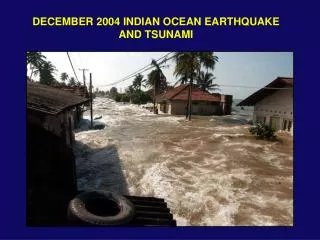
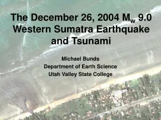
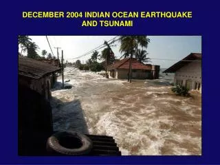
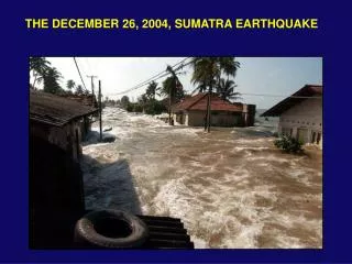
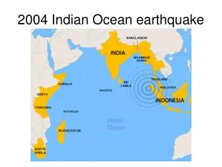
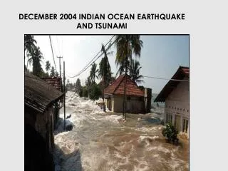
DECEMBER 2004 INDIAN OCEAN EARTHQUAKE AND TSUNAMI. EARTHQUAKE HAZARDS. Primary Ground shaking and surface rupture Liquefaction Landslides Tsunami Secondary Fires Floods. Earthquake Magnitude and Intensity.

E N D
EARTHQUAKE HAZARDS • Primary • Ground shaking and surface rupture • Liquefaction • Landslides • Tsunami • Secondary • Fires • Floods
Earthquake Magnitude and Intensity Intensity is a measure of the effects of an earthquake at a particular place on humans, structures and (or) the land itself. The intensity at a point depends not only upon the strength of the earthquake (magnitude) but also upon the distance from the earthquake to the point and the local geology. Richter Magnitude is a measure of the strength of an earthquake, as determined by seismographic observations. An increase of one unit of magnitude (M3 to M4) represents a 10-fold increase in wave amplitude on a seismogram or approximately a 30-fold increase in the energy released.
Worldwide earthquakes per year: Frequency-magnitude relations suggests that magnitude 9+ events occur about once per decade. Statistically, since 1900, the actual number is ~once per 20 years.
Earthquake magnitude controlled by fault length rupture Magnitude versus fault length Magnitude versus fault length (determined from aftershock zone length) for various earthquakes. Alaska, 1964 Sumatra, 2004 Denali, 2002 Landers, 1992 Loma Prieta, 1989 Northridge, 1994
COMPLEX PLATE BOUNDARY ZONE IN SOUTHEAST ASIA Northward motion of India deforms all of the region Many small plates (microplates) and blocks Molnar & Tapponier, 1977
Tsunami-generating EQs and sources Geist, Titov and Synolakis, Tsunami: Wave of Change, Scientific American, January, 2006.
India subducts beneath Burma microplateat about 50 mm/yrEarthquakes occur at plate interface along the Sumatra arc (Sunda trench)These are the destructive results of many years of accumulated plate motion
Sumatra earthquakes • What other great (M > 8) earthquakes have occurred in the region? • Since 1900 and prior to the December 26 earthquake, the largest subduction EQs in southern Sumatra to the Andaman Islands occurred in 2000 and had a magnitude of 7.9. • M 8.4 earthquake occurred in 1797 • M 8.5 in 1861 • M 8.7 in 1833 • All three ruptured sections of the subduction zone to the south of the 2004 earthquake. • The 1797 and 1833 EQ’s ruptured roughly the same area with only 36 years separating the events. • Paleoseismic evidence shows that great earthquakes or earthquake couplets occur about every 230 years
INTERSEISMIC: Relative plate rate about 50 mm/yr Fault interface is locked EARTHQUAKE (coseismic): Fault interface slips, overriding plate rebounds, releasing accumulated motion HOW OFTEN: Fault slipped ~ 10 m = 10000 mm / 50 mm/yr 10000 mm / 50 mm/yr = 200 yr Longer if some slip is aseismic Faults aren’t exactly periodic for reasons we don’t understand
MODELING SEISMOGRAMS shows how slip varied on fault plane Maximum slip area ~400 km long Maximum slip ~ 20 m Seismograms under estimate slip patch
TWO VIEWS OF THE PART OF THE SUMATRA SUBDUCTION ZONE THAT SLIPPED ERI C. Ji Seismogram analysis shows most slip in southern 400 km Aftershocks show slip extended almost 1200 km
Earthquakes rupture a patch along fault's surface. • The larger the rupture patch, the larger the earthquake magnitude. • Initial estimates from the aftershock distribution show the magnitude 9.3 Sumatra-Andaman Islands EQ ruptured a patch of fault roughly the size of California • For comparison, a magnitude 5 earthquake would rupture a patch roughly the size of New York City's Central Park.
NORMAL MODES (ULTRA-LONG PERIOD WAVES) SHOW SEISMIC MOMENT 3 TIMES THAT INFERRED FROM SURFACE WAVES • IMPLIES SLIP ON AREA 3 TIMES LARGER • Entire 1200-km long aftershock zone likely slipped
SEISMIC MOMENT Mo 1 x 1030 dyn-cm 2.5 TIMES BIGGER THAN INFERRED FROM 300-s SURFACE WAVES CORRESPONDING MOMENT MAGNITUDE Mw 9.3, COMPARED TO 9.0 FROM SURFACE WAVES Comparison of fault areas, moments, magnitudes, amount of slip shows this was a gigantic earthquake “the big one”
IF ENTIRE ZONE SLIPPED, STRAIN BUILT UP HAS BEEN RELEASED, LEAVING LITTLE DANGER OF COMPARABLE TSUNAMI Risk of local tsunami from large aftershocks or oceanwide tsunami from boundary segments to south remains
EARTHQUAKE MAGNITUDE 9.3 Stein & Wysession after IRIS One of the largest earthquakes since seismometer invented ~ 1900
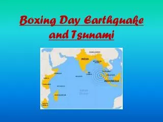
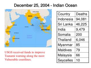
What other significant tsunamis have occurred in the region? The following destructive tsunamis (Tsunami Laboratory, Institute of Computational Mathematics and Mathematical Geophysics) 1. 1797/02/10 Central part of the western Sumatra. The quake was most felt near Padang and in the area within +/-2 deg of equator. Padang was flooded by powerful waves. More then 300 fatalities. 2. 1833/11/24 South coast of the western Sumatra, estimated rupture from 1 S to 6 S latitude. Huge tidal wave flooded all southern part of the western Sumatra. Numerous victims. 3. 1843/01/05 Strong earthquake west of the central Sumatra. Terrible wave came from the south-east and flooded all the coast of the Nias Island. Many fatalities. 4. 1861/02/16 Exceptionally strong earthquake affected all the western coast of Sumatra. Several thousand fatalities. 5. 1883 Krakatau explosion 36,000 fatalities
TSUNAMI GENERATED ALONG FAULT, WHERE SEA FLOOR DISPLACED, AND SPREADS OUTWARD Hyndeman and Wang, 1993 Red - up motion, blue down http://staff.aist.go.jp/kenji.satake/animation.gif
TSUNAMI SPEED IN DEEP WATER of depth d c = (gd)1/2 g = 9.8 m/s2 d = 4000 m c = 200 m/s = 720 km/hr = 450 m/hr Tsunami generated along fault, where sea floor displaced, and spreads outward Reached Sri Lanka in 2 hrs, India in 2-3 http://staff.aist.go.jp/kenji.satake/animation.gif
IN DEEP OCEAN tsunami has long wavelength, travels fast, small amplitude - doesn’t affect ships AS IT APPROACHES SHORE, it slows. Since energy is conserved, amplitude builds up - very damaging
Tsunami wave height (2 hours after earthquake) measured from satellite radar altimetry NOAA
Tide gauge record, east coast of India Tsunami (~1.2 m maximum wave height; note that waves are visible for over 2 days) Normal tide variation
Wave Heights: Satellite observation vs calculated model Geist, Titov and Synolakis, Tsunami: Wave of Change, Scientific American, January, 2006.
Tsunami wave propagation characteristics – note that as water depth becomes smaller, waves slow down, become shorter wavelength, and have larger amplitude NOAA When the water is 10 m deep, what is the separation of the waves in minutes?
Chedi Resort, Phuket, Thailand, wave height ~4+ m (from estimates of water level from beach umbrellas on grassy area above the beach).
Earthquake and Tsunami Damage, Banda Aceh, Sumatra
Earthquake and Tsunami Damage, Sri Lanka
Train and tracks destroyed, SW coast of Sri Lanka Geist, Titov and Synolakis, Tsunami: Wave of Change, Scientific American, January, 2006.
TSUNAMI WARNING Because seismic waves travel much faster (km/s) than tsunamis, rapid analysis of seismograms can identify earthquakes likely to cause major tsunamis and predict when waves will arrive Deep ocean buoys can measure wave heights, verify tsunami and reduce false alarms
HOWEVER, HARD TO PREDICT EARTHQUAKES recurrence is highly variable Sieh et al., 1989 Extend earthquake history with geologic records -paleoseismology M>7 mean 132 yr s 105 yr Estimated probability in 30 yrs 7-51%
EARTHQUAKE RECURRENCE AT SUBDUCTION ZONES IS COMPLICATED In many subduction zones, thrust earthquakes have patterns in space and time. Large earthquakes occurred in the Nankai trough area of Japan approximately every 125 years since 1498 with similar fault areas In some cases entire region seems to have slipped at once; in others slip was divided into several events over a few years. Repeatability suggests that a segment that has not slipped for some time is a gap due for an earthquake, but it’s hard to use this concept well because of variability GAP? NOTHING YET Ando, 1975
EARTHQUAKE PREDICTION? Because little is known about the fundamental physics of faulting, many attempts to predict earthquakes searched for precursors, observable behavior that precedes earthquakes. To date, search has proved generally unsuccessful In one hypothesis, all earthquakes start off as tiny earthquakes, which happen frequently, but only a few cascade via random failure process into large earthquakes This hypothesis draws on ideas from nonlinear dynamics or chaos theory, in which small perturbations can grow to have unpredictable large consequences. These ideas were posed in terms of the possibility that minuscule disturbances do not affect the overall frequency of storms but can modify when they occur If so, there is nothing special about those tiny earthquakes that happen to grow into large ones, the interval between large earthquakes is highly variable and no observable precursors should occur before them. Thus earthquake prediction is either impossible or nearly so. “It’s hard to predict earthquakes, especially before they happen”
Mt Saint Helens 1980 eruption PLATE TECTONICS IS DESTRUCTIVE TO HUMAN SOCIETY USGS • 1989 Loma Prieta earthquake
BUT PLATE TECTONICS IS ALSO CRUCIAL FOR HUMAN LIFE Plate boundary volcanism produces atmospheric gases (carbon dioxide CO2 ; water H2O) needed to support life and keep planet warm enough for life ("greenhouse" ) May explain how life evolved on earth (at midocean ridge hot springs) Plate tectonics raises continents above sea level Plate tectonics produces mineral resources including fossil fuels Press & Siever
“CIVILIZATION EXISTS BY GEOLOGICAL CONSENT” The same geologic processes that make our planet habitable also make it dangerous