Download
1 / 21
210 likes | 601 Views
Flight Readiness Review ALIVE (Aerosol LIDAR Validation Experiment). August 31, 2005 Beat Schmid, BAER Institute Joseph “Ben” Hovelman, Sky Research Roy Johnson, NASA ARC. Background. ALIVE is a DOE funded mission utilizing NASA instruments and staff.

E N D
Flight Readiness ReviewALIVE (Aerosol LIDAR Validation Experiment) August 31, 2005 Beat Schmid, BAER Institute Joseph “Ben” Hovelman, Sky Research Roy Johnson, NASA ARC
Background • ALIVE is a DOE funded mission utilizing NASA instruments and staff. • DOE also conducts safety reviews for the ALIVE aircraft in addition to the NASA safety review. • Dr. Beat Schmid won DOE peer reviewed funding for ALIVE and is the Project Manager as well as the PI for the Ames Sunphotometer during the mission.
Purpose • Validate Aerosol Extinction Profiles over ARM CRF in Oklahoma derived from ground-based Raman and Micropulse Lidars • Validate Aerosol Extinction Profiles derived from ARM Cessna 206 in-situ aerosol plane (IAP) • Derive aerosol optical properties by combining AATS-14 and RSP measurements.
J-31 at Moffett Field Timeframe • September 7 (Wednesday): Sky Research Jetstream 31 will arrive at Moffett Field • September 8-10: Instrument integration (AATS-14, NavMet, Aplanix POS, and RSP) into J-31 • September 10 (Saturday): J-31 test flight (30 to 45 minute duration) • September 11 (Sunday): J-31 departs for Ponca City, Oklahoma • September 22: J-31 returns to Moffett Field • September 23: Science Instrumentation removed from J-31 at Moffett Field
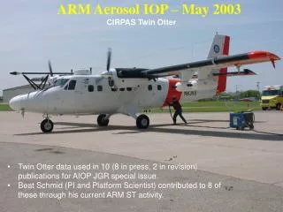
Aerosol Lidar Validation Experiment (ALIVE) AATS-14 on Sky Research J-31 Research Scanning Polarimeter NavMet Aplanix POS Cessna 206 Raman Lidar Micro Pulse Lidar DOE Oklahoma, Sep 11-22, 2005 Lead Scientist: B. Schmid http://geo.arc.nasa.gov/sgg/ALIVE
14-channel Ames Airborne Tracking Sunphotometer (AATS-14) Measures: Solar direct-beam transmission, T, at 14 wavelengths, l, 353-2139 nm Data products • Aerosol optical depth (AOD) at 13 l, 353-2139 nm • Water vapor column content [using T(940 nm)] • Aerosol extinction, 340-2139 nm • Water vapor density } When A/C flies vertical profiles
Research Scanning PolarimeterPI: Brian Cairns, NASA GISS • Measures upwelling polarized radiation • ±60° angular scan • 410, 470, 555, 670, 865, 960, 1590, 1880, 2250 nm
AIRPORT FACILITIES Aircraft modification, sensor installation, and maintenance activities are based at the Sky Research hangar at Ashland Airport (S03) located in southern Oregon. Sensor re-installation and test-flight will be based out of NASA Ames-Moffett Field (NUQ) in California. Instrument deployment flights to the DOE SGP CRF will be based at Ponca City Regional Airport (PNC) in north-central Oklahoma.
Operations • Flights centered on ARM CRF 36.60°N, 97.48°E. • Timeframe: Sep. 11 – 22, 2005 • 10 days on site • 23 on-site research flight hours • 10-15 short duration flights • VFR only, avoid sun obscured by cirrus clouds • Two types of flight patterns
Type 2: Intercomparison Flights • J-31 will wait until Cessna starts its 15K’ leg then take off (~25 min lag) • Vertical separation is always more than 1500 ft • ATC radar flight following at all times • Continuous radio contact between 2 aircraft • J-31 will RTB immediately if radio contact is lost • 3-4 such flights
AIRCRAFT DESCRIPTION • Jetstream 31, N22746: • Pressurized, twin-engine turbo prop aircraft, modified to provide an Airborne Sensor Platform for research, survey, and reconnaissance missions • Large, wide cabin with standing headroom and oversized cargo pod for flexibility in deploying multiple sensors • A 10” NVG observation bubble window, dual SAT COM communication, dual GPS navigation, 8 position intercom, extensive inventory of aircraft spares and ground support equipment, survival equipment, and extended range fuel tanks provide for worldwide operations Jetstream 31, Sky Research Facilities, Ashland Municipal Airport, Oregon
Pilot Qualifications Joseph Hovelman • Total Hours: 4300 • Jetstream Total Hours: 723 William Seiber • Total Hours: 4900 • Jetstream Total Hours: 595
Jetstream 31 Safety • The aircraft is equipped with fire extinguishers and oxygen masks. • Pilots have 2 emergency switches to shut down power to all research equipment. • There is no emergency egress impact as a result of the experimental instrument installation. • No flights over water will be made. • No additional safety equipment is required. • Any emergencies or abnormalities will be handled per aircraft manufacturer's recommendations and procedures taught by Flight Safety International. • Downlink Transmissions: none
Radiation Uses • All instruments onboard are of passive nature. • Will fly Minimum of 500 feet over ground-based LIDAR beams. • Micro Pulse Lidar, = 523 nm. Eye safe at zero range and beyond. Detailed calculations available. • Raman Lidar, =355 nm. Eye safe at output of beam. Detailed calculations available. • No optics will be used to look at lidar beams
RSP Mechanical Description The RSP in the instrument bay View of the RSP from below with the bay cover RSP Support Electronics box and panel in the aft of the J-31. RSP control monitor in the rack at the fore of the J-31 Structural Analysis of RSP integration available on request. http://geo.arc.nasa.gov/sgg/ALIVE/Photos_ALIVE/RSPinteg_photos/RSPinteg.html Pictures and descriptions by Kirk Knobelspiesse
Preflight Inspection • In addition to Standard J-31 Pilot Preflight Inspections, the following are preflight inspection requirements for the research equipment on board. • AATS-14 • Remove AATS-14 rain bucket • Visually inspect AATS-14 safety wires • RSP • Remove N2 Purge
RiskManagement • Only one new instrument (RSP). Remaining equipment flown on J-31 before • May 24, Sky Research certified and included in DOE’s Accepted Aircraft Operator Database http://ma.mbe.doe.gov/me24/acdb/fetchall.cfm • June 28, approved to fly ALIVE in Vance MOA (Maj DiNatale) • June 28, J-31 ALIVE operations approved by Robert Hannigan (PNNL Aircraft Safety Officer) Tel. (509) 372-6167 • July 21 prelim FRR meeting • July 25, end-to-end test Aplanix/POS, NavMet and AATS-14 in lab successful • Aug 8, start install RSP instrument Ashland • Aug 9, FRR rep inspects RSP install • Aug 10, test flight RSP successful • Aug 12, PNNL Aviation Safety Meeting to review revised operations: Approval has been received pending final paperwork from the aircraft operator • Aug 17, DOE Aviation Safety Meeting: DOE has approved the aircraft for ALIVE pending receipt of final paperwork from aircraft operator. • Aug 31, Ames FRR • Sep 8-10, instrument re-integration and test flight, Moffett Field • Sep 11, transfer to Ponca City
Single Point of Failure Review & Mitigation • We do not see a “Single Point of Failure” for the J-31 ALIVE operations. • Risk Matrix Examples • Electronic fire • Instrument breaking loose
Low RISK MATRIX AR 385-16, MIL-STD-882C, ATTC MEMO 70-12