Download
1 / 21
210 likes | 379 Views
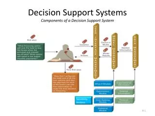
NWS' Howard Hanson Dam decision support: new observations, guidance, and services . Brad Colman, Sc.D. National Weather Service - Seattle/Tacoma 20 April 2010 National MIC-HIC meeting Lansdowne Resort; Leesburg, VA. Outline. Background: the problem and timeline

E N D
NWS' Howard Hanson Dam decision support: new observations, guidance, and services Brad Colman, Sc.D. National Weather Service - Seattle/Tacoma 20 April 2010 National MIC-HIC meeting Lansdowne Resort; Leesburg, VA
Outline • Background: the problem and timeline • Local planning and actions • National support and actions • A key success • Lessons learned
Howard Hanson Dam Green River Landslide Debris • In service - 1962 • HHD is located 64 miles from Puget Sound • Dam is an earth and rock-fill structure with a sand core and gravel drain • Drainage Tunnel Completed in 1969 • Original Grout Curtain installed - 2002 Small Depression Location Existing Grout Curtain Drainage Tunnel Right Abutment Big Depression Location Spillway Engineered Filter Blanket Embankment Flood Control Tower Eagle Gorge Reservoir Fish Passage Facility Excavation
What’s happened since 1962? • Population has grown to 400k (170k flood risk area) • $46 M in economic activity per day • Large warehouse and distribution district • A population that has never experienced flooding
Local planning and activities • Key planning partners • USACE • King County (Emergency Management, Flood Warning Center) • FEMA and WSEMD • Cities (Auburn, Kent, Renton, Tukwila) • Elected Officials • NWS (WFO Seattle, NWRFC) • Green River Planning Group (NWS involvement) • Policy committee • Notification and Warning committee • Outreach and Education committee
More Partnered Efforts • MANY MANY Meetings, Briefings, and Workshops • Media tour with USACE • NWS Media/Emergency Management Workshops • Governor’s sub-committee updates • Exercises • USACE Exercise - late August • County/City week long “No Notice” Drill - late September • Joint Development of 3-5 Day Trigger Point thresholds (more on this later)
A Few Local NWS Actions • WFO Seattle • HHD Severe Weather Operation Plan • Dedicated HYDROLOGY Section in AFD • HHD ‘One-Stop Shopping’ Web Page • ‘Flooding 101’ Paper • NWRFC • Recalibration of Green River modeling • Input to precipitation gage placement • Internal HHD Web Page • Adjusted forecast priorities
NOAA’s New Mobile Atmospheric River Monitoring System (Mobile-ARMS) 10-m met. tower (folds down for storage) First deployment at Westport, WA, for Winter 2009/2010 “You need more of these, right?” Satellite communications GPS receiver for IWV Office and storage facility 915-MHz wind profiler on swivel to aid deployment and maximize data recovery with respect to beam directions and ground clutter S-band precipitation profiling radar (S-PROF) Backup generator
Additional Resources • Observations • 14 additional or upgraded rain gauges • 2 Atmospheric River Observatory systems • Additional Workstations • AWIPS workstation • GeoTargeted Alerting System (GTAS) • Advanced Linux Prototype System (ALPS) • NCEP/EMC/HPC support • Mix of QPF and PQPF products • GEFS, SREFS, and HPC techniques • 24-h and 6-h with specific thresholds • Days 1-7 HPC; and to 15 days for GEFS
An Urgent Community Need:Lead Time • Staging equipment and supplies (up to 10 days) • Evacuation of facilities(up to 5 days) • Minimum of 3 days for most activities
Request: “We need Macro Level Trigger Points (Minimal, Low, Moderate concern) for Long-Lead Flood Response Activities for the Green River Basin.” From a 2 November 2009, Trigger Point development meeting Action: The Northwest River Forecast Center, Seattle Weather Forecast Office, and USACE – Seattle District, initiated a collaborative project to establish 24-hour Forecast Precipitation Thresholds with probability information that could be linked to three different long-lead Flood Concern Levels (Minimal, Low, Moderate) on the Green River.
Results Decision > 6.0 < 4.0
The objective thresholds allowed the NWS HPC and EMC to develop the specific guidance products in support of the forecast process A forecaster GUI was developed by local SOO to address forecaster workload Twice-daily email alerts were issued to EMs and partners alerting them to any developing risk in the 3 to 5 day period The alert levels were integrated into each involved agency’s operation plan ensuring a coordinated response NWS Guidance and Implementation
Flood Outlook Flood Watch Flood Warning Extended Briefings Briefings NWS Flood Action Time Line for Green River 66 63 60 57 Forecast Discussion Alert Thresholds Extra long-Lead Guidance
Feedback from Dr. Dennis Hunsinger, Acting Regional Administrator, FEMA: "This work represents the very best of what can happen when we all work together collaboratively with our partners."
Summary • NOAA/NWS at all levels leaned forward to meet the needs of impacted agencies and citizens • A balance between the state of weather and water forecasting science and user needs • Excellent collaboration -- A learning process • The NWS needs an established mechanism to recognize similar, critical challenges. Some kind of Rapid Response process for DSS efforts.