Download
1 / 1
20 likes | 333 Views
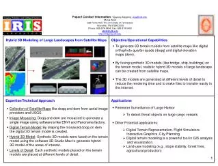
Project Contact Information : Vijayaraj Alagarraj, vijay@utk.edu Mongi Abidi 328 Ferris Hall, The University of Tennessee Knoxville, TN 37996-2100 Phone: 865-974-5454; Fax: 865-974-5459 abidi@utk.edu http://imaging.utk.edu. Hybrid 3D Modeling of Large Landscapes from Satellite Maps.

E N D
Project Contact Information: Vijayaraj Alagarraj, vijay@utk.edu Mongi Abidi 328 Ferris Hall, The University of Tennessee Knoxville, TN 37996-2100 Phone: 865-974-5454; Fax: 865-974-5459 abidi@utk.edu http://imaging.utk.edu Hybrid 3D Modeling of Large Landscapes from Satellite Maps Objective/Operational Capabilities • To generate 3D terrain models from satellite maps like digital orthophoto quarter quads (doqq) and digital elevation maps (dem). • By fusing synthetic 3D models (like bridge, ship, buildings) on the terrain model, realistic hybrid 3D models of large landscape can be created from satellite maps. • The 3D models are generated at different levels of detail to reduce the rendering time and to make files to transfer easily in the internet. Expertise/Technical Approach Applications • Perimeter Surveillance of Large Harbor • To detect threat objects on large cargo vessels • Other Potential applications: • Digital Terrain Representation, Flight Simulators Interactive Graphics, City Planning • Digital terrain modeling is a powerful tool in GIS analysis and visualization. • Land-use modeling (e.g., slope stability, forest fires, agricultural production) • Collection of Satellite Maps like doqq and dem from aerial image providers and USGS. • Image Mosaicing: Doqq and dem are mosaiced to generate a single image using software’s like ENVI and Panorama factory. • Digital Terrain Model: By draping the mosaiced doqq on dem the digital 3D terrain model is created. • Hybrid 3D Model: Synthetic 3D models were fused on the terrain model using the software 3D Studio Max to generate hybrid 3D model of the areas of interest. • Levels of Detail: Each synthetic models placed on the terrain models are placed at different levels of detail.