Download
1 / 16
160 likes | 328 Views
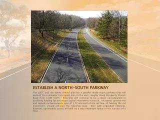
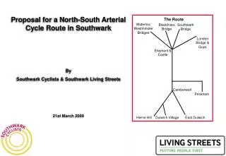
Proposal for a North-South Arterial Cycle Route in Southwark By Southwark Cyclists & Southwark Living Streets 21st March 2009. The Route. Waterloo/ Westminster Bridges. Blackfriars Bridge. Southwark Bridge. London Bridge & Guys. Elephant & Castle. Camberwell. Peckham. Herne Hill.

E N D
Proposal for a North-South Arterial Cycle Route in Southwark By Southwark Cyclists & Southwark Living Streets 21st March 2009 The Route Waterloo/ Westminster Bridges Blackfriars Bridge Southwark Bridge London Bridge & Guys Elephant & Castle Camberwell Peckham Herne Hill Dulwich Village East Dulwich
Introduction. • This document outlines our vision for a north-south cycle route in Southwark. The idea is to create the first of a number of arterial routes in Southwark. For this first route, we are seeking to create a spine that would run from Herne Hill, Dulwich Village, East Dulwich and Peckham in the south of the borough to five river crossings in the north of Southwark. • The principal drivers of this project are: • To create a cycling infrastructure that encourages the next wave of cyclists to make journeys on their bikes. • To create a major safe route for cyclists to help reverse the increases in cycling casualties that Southwark has seen in recent years. • To make the most of the enormous health benefits of cycling through the improvements that it can make to personal health and fitness (and tackling obesity) and the attendant improvements it makes to congestion levels and air pollution. • Our route consists of three main parts: 1. Routes from Herne Hill, Dulwich Village, East Dulwich and Peckham to Camberwell. 2. A route from Camberwell to the Elephant (either via the Walworth Rd or the existing LCN+ route on Portland St). 3. From the Elephant to the river by 5 routes – London Bridge, Southwark Bridge, Blackfriars Bridge, Waterloo and Westminster Bridges. • These would be safe, quick and direct routes that would be attractive for experienced and novice cyclists alike. In itself, it would be a cycling super highway; in time it would be the spine that other routes could connect to and cross to create a modal shifting array of safe cycle routes that would at last offer cycling the chance to reach its potential in Southwark.
Introduction (continued). We feel that there are a number of strong reasons for creating this route. • This idea builds on a number of initiatives: Southwark Cyclists & Southwark Living Streets have been promoting the idea of a network of cycle routes connecting the towns and villages of Southwark. A recent LIP bid envisaged the creation of a protected cycle route from the Elephant & Castle to the river along Southwark Bridge Road. This is the first realisation of a major route through the borough. The Sustrans Project South-East London Greenways. Much of the route has already been looked at as part of this project. These two schemes would dovetail well together. Some parts of the proposed route are already part of LCN+. The Mayor of London’s proposal for “barrier-busting” cycle routes into London that will be attractive to less confident cyclists. The needs of large employers in Southwark. Health providers in Camberwell need to move large numbers of staff to and from sister sites at Guy’s and St. Thomas’ Hospitals. Cycling could easily become the fastest (and healthiest) way for them to travel, particularly after threatened cuts in rail services from Denmark Hill Station. It works abroad. The reasons that so many people cycle in north-west Europe (cycling has 25% modal share in Copenhagen, 37% in Amsterdam and 57% in Groningen (NE Holland)) is the provision of a safe cycling infrastructure consisting principally of low vehicle speeds (30kph limit on roads in towns) and routes where cyclists are separated from motor vehicles. With the abandonment of the Cross-River Tram, cycling offers a cost-effective method of easing pressure on public transport in the north of the borough and offering swift travel from those locations that the tram would have served. The route would pass by or very near many of Southwark’s schools, helping pupils cycle to and from school, with the consequent benefits for congestion, obesity and the environment.
What Would The Route Be Like? – Requirements For Cycling In Southwark. • Our aim is to provide a safe cycle facility, attractive to less experienced as well as experienced cyclists. We also want the streets along which the routes pass to be as pedestrian friendly and aesthetically pleasing as possible. • To achieve these aims vehicle speeds must be limited to the safe and legal maximum. Fast traffic endangers the lives of all road users, including occupants of vehicles. • We suggest a number of treatments to achieve these aims which could be used at various points along the proposed routes. These are: • 1. To enforce speed limits and sensible speeds using: • the newly available 20 mph cameras • street designs, such as reducing the width of excessively wide carriageway and raised pedestrian crossings • calming features, such as trees • where the carriageway is wide enough, the trees should be planted in the centre of the carriageway, creating a boulevard. • 2. To protect and give confidence to inexperienced cyclists, protection for cycle lanes where there is sufficient space. We believe that the requirement for a minimum width of cycle lane of one and a half metres precludes safe cycling provision in many situations. (It is the best being the enemy of the good.) We suggest that, for a one way cycle lane in roads with constricted widths a lane about one metre wide, protected by a series of narrow bollards, protruding, if necessary, a little into the cycle lane, would make possible safe and satisfactory provision for cyclists in many situations. Confident cyclists would, of course, have the option of riding in the main vehicle lanes. Safe protected cycle lanes. Excellent provision on Southwark Bridge.
What Would The Route Be Like? – Requirements For Cycling In Southwark (continued). • Proposed treatments (continued) • 3. Bus lanes, even with motorbikes in them, provide a good environment for cyclists. • 4. Cyclists should be protected from danger from vehicles going in or out of side roads, by: • continuing cycle lanes across the mouths of side roads; • reducing the widths and tightening the splays of the mouths of side roads ; • raising the carriageway at the ends of side roads to reduce the speeds of vehicles there. • 5. All signalised junctions should have ASLs. • 6. Signs to help cyclists identify feeder routes along the way. Examples are: to the Elephant and Castle cycle bypass; and to the Greendale off-road path. Signs are needed both at and before junctions, both on-carriageway and on posts (integrated with other street furniture, to avoid clutter) Confirmatory signs are also needed shortly after junctions to reassure cyclists that they are on the correct route. • Most of these measures assist pedestrians and improve the public realm in addition to their direct benefit for cyclists. • A particular category of people to benefit from these measures would be school pupils, many of whom have to cross main roads to get to and from school. Elephant & Castle – Current cycle bypass.
Overview Of The Route • The route is described in detail in the following pages. It is broken down into the following sections. A. Between Herne Hill and Camberwell The Route Blackfriars Bridge Southwark Bridge Waterloo/ Westminster Bridges B. Between Dulwich Village and Camberwell London Bridge & Guys C. Between East Dulwich and Camberwell Elephant & Castle D. Between Peckham and the Elephant & Castle, using Portland Street E. Between Camberwell and the Elephant & Castle, using Walworth Rd F. Between the Elephant and Castle and London Bridge Camberwell G. Between the Elephant and Castle and Southwark Bridge Peckham H. Between the Elephant and Castle and Blackfriars Bridge I. Between the Elephant & Castle and Waterloo/Westminster Bridges Herne Hill Dulwich Village East Dulwich
Section A. Between Herne Hill and Camberwell – Part 1: Herne Hill to Red Post Hill. In the southward direction, there would be room for a one metre protected cycle lane from the junction with Red Post Hill to the Herne Hill junction. Very few on-street parking spaces would be lost. The outlet of Casino Avenue onto Herne Hill is a particularly prominent example of excessive splays, endangering and intimidating pedestrians and cyclists. This should be narrowed significantly and become a simple T junction. The recently constructed raised zebra crossing at Herne Hill School slows traffic, especially going down the hill (southwards). The crossing outside the shops between Elfindale Road and Danecroft Road should also be raised. The road called Herne Hill leading northward just after the junction is wider than necessary and invites drivers to speed up, especially if they have been delayed at the junction. Junction Red Post Hill • The junction of Herne Hill, Denmark Hill, Red Post Hill and Herne Hill Road would benefit from the following measures for the benefit of cyclists, pedestrians and the public realm: • some tightening of kerb lines, e.g. on the southern corner (with Red Post Hill); • planting of trees or shrubs in the centre of the carriageway to the south and north of the junction, to calm vehicle speeds; • a raised table across the whole junction. Herne Hill The footway on the western side, where bus passengers wait for buses on a very narrow pavement, should be widened. This would slow traffic and still leave sufficient width for a one metre protected cycle lane northwards up from the junction to the beginning of the bus lane.
. Section A. Between Herne Hill and Camberwell – Part 2: Red Post Hill to Camberwell. From the junction with Red Post Hill northwards to the junction with Champion Hill the carriageway is so wide that, even with bus lanes on both sides, vehicle speeds are excessive. This is recognised by the hatching in some sections in the centre of the carriageway. Consideration should be given to planting trees in the centre of the carriageway at certain points along this stretch of road and, in the longer term, the use of average speed cameras to enforce speed limits. From Champion Park to Camberwell Green a protected cycle lane is needed on the eastern side, to complement the protection provided by the bus lane on the western side Camberwell Green All along this stretch, wherever there are not bus lanes, there should be protected cycle lanes, as described in the introduction. There is sufficient carriageway width throughout The mouths of all the roads onto Denmark Hill, including the entrance to the Fox on the Hill, need entry treatments and some of them need narrowing and tightening. • The junction with Champion Hill is unfriendly for cyclists, pedestrians and local residents in the following ways: • Cyclists going northwards have the protection of a bus lane, but traffic speeds on this downhill stretch are excessive and intimidating. • Cyclists going southwards have little protection from vehicles coming out of or into Champion Hill. A continuous cycle lane across the mouth of Champion Hill is needed. • Speeds need to be moderated by calming measures, for instance by widening the existing central planting strip to the south of the junction. • The desire line for the way to the park from the housing on the eastern side of Denmark Hill is blocked by railings (no doubt because of excessive vehicle speeds). This needs addressing. Junction Red Post Hill Pedestrian crossings are needed at several points along this long stretch of road, especially to enable people to cross from large areas of housing on the east side of the road and houses on the west side of the road to the several bus stops. These pedestrian crossings should be raised, for the safety of pedestrians and to slow traffic.
Section B. Between Dulwich Village and Camberwell. Between Dulwich Village and Denmark Hill, the route takes advantage of the 20 mph measures currently being implemented in Dulwich Village and the off-road cycle and pedestrian path along Greendale. Between Denmark Hill and Camberwell the route follows that to and from Herne Hill. Camberwell Green Dulwich Village Views of Greendale Junction Red Post Hill
Section C. Between East Dulwich and Camberwell. • Between East Dulwich (Goose Green) and Camberwell, the following route is proposed: • Grove Vale (taking advantage of the newly improved roundabout layout at Goose Green • Dog Kennel Hill • Grove Hill Rd • Camberwell Grove. Views of Grove Vale Grove Hill Rd Camberwell Grove is an excellent route for cyclists (calmed effectively by full-width humps) and is already heavily used for those travelling north-south. East Dulwich Camberwell Green There are currently significant problems with Grove Vale with high levels of casualties for both cyclists and pedestrians which stem from high vehicles speeds and poor quality crossings (owing to parked cars and poor sightlines) for those who need to cross between the shops in the area. We propose that Grove Vale should be calmed, with more street trees, including some in the centre of the wide carriageway. Dog Kennel Hill also experiences high levels of pedestrian and cyclist casualties owing to high vehicles speeds on a road that is inappropriately built as a dual carriageway. Speeds need to be reduced throughout and the entrance to Sainsbury’s store needs to be reconfigured to reduce speeds and danger to cyclists. Champion Hill
Section D. Between Peckham and the Elephant & Castle, using Portland Street. Heygate St East St Albany Rd Peckham Square Current NKR crossing on the E&C cycle bypass (dotted line) Portland St. is part of the LCN+ Route BUT many vehicles use this stretch and we know vehicle speeds are high (86% of vehicles move at >20mph). It needs further improvements for cyclists, including (i) raised tables at the junctions with side roads, to calm traffic speeds and to protect cyclists and pedestrians from cars emerging from these side roads; (ii) tree planting in several places, such as just south of East Street. New Kent Rd Burgess Park Heygate Estate Brandon St Elephant & Castle Portland St. A direct high quality cycle routes is needed through the redeveloped E&C/Heygate Estate area avoiding the need for the current long detour around the E&C cycle bypass. North from Peckham High Street, the route along the old canal is safe, and delightful. The route joins the east/west wide path through Burgess Park, crossing Trafalgar Avenue. The crossing is a shared and acceptably safe pedestrian/ cyclist crossing. The path across the green from the north end of the canal path to Trafalgar Avenue needs widening, to accommodate cyclists and pedestrians. The intersection of Portland Street and the heavily used East Street is dangerous and needs (i) a raised table; (ii) footways built out and radii tightened; and (iii) traffic calming on the approaches to the intersection. A new spur is needed between the east/west path along Burgess Park and Albany Road just west of Portland Street, with a short shared cyclist/pedestrian section on the south side of Albany Road to the traffic signals at Portland Street.
Section E. Between Camberwell and the Elephant & Castle, using Walworth Rd. Albany Rd From Albany Road northwards, in order to complement on the eastern side the protection provided by the bus lane on the western side, the footway should be widened and shared with cyclists. This section will be evaluated as part of the Camberwell Green area study for the proposed Area Based Scheme. Walworth Rd Scheme Stretch We do not propose any changes to this. Elephant & Castle Camberwell Green • The carriageway on most of this stretch is excessively wide. Vehicles consequently move very fast through this stretch. There are few crossings to shops and bus stops (this is a particular problem at the Castlemead Estate). In places there are as many as six lanes of traffic. Measures needed include: • immediately north of Camberwell Green, near the late night dancing venue, previously The Father Red Cap pub, some selective widening of footways and footway tree planting. • further north, where the road widens opposite the parade of shops reduce the number of vehicle lanes (one less); plant a row of trees in the centre of the carriageway and install a raised pedestrian crossing to the shops.
Section F. Between the Elephant and Castle and London Bridge. London Bridge • Newington Causeway • There are a large number of problems with Newington Causeway that have been highlighted in the Major Borough Roads document by Southwark Living Streets. Casualty levels are high for both pedestrians and cyclists on a road that is both too wide and too fast. We feel that this road needs to be drastically rethought to allow it to become a quick safe link (just 15 minutes on foot) between the Elephant & London Bridge. More specifically we note that: • Northbound cyclists are provided with a signalised junction from Rockingham Street, but this could be improved by making it more prominent and some adjustment of the kerb line at the exit from Rockingham Street. • The new entry treatment at Gaunt Street is excellent. • There are opportunities for a boulevard type approach with, for example, a line of trees along the centre of the road. • Borough High St. • Most of the section northwards from Borough Road to Marshalsea Road/Long Lane is wide enough for protected cycle lanes where protection is not available from bus lanes. The southernmost part, between Borough Road and Suffolk Street/Trinity Street, is wide enough to encourage speeding but not wide enough for protected cycle lanes. Some selective widening of footways and footway tree planting would reduce speeds. • From Marshalsea Road/Long Lane northwards Borough High Street is busy with many pedestrians, buses, other traffic and general business. The main short term measures to assist cyclists would be full enforcement of a 20 mph speed limit and raised pedestrian crossings. In the longer term treatments along the lines of the Walworth Road are needed. London Bridge is wide enough for protected cycle lanes wherever the bus lanes do not provide sufficient protection. Borough Tube Station Guy’s Hospital Elephant & Castle Rockingham St junction.
Section G. Between the Elephant and Castle and Southwark Bridge. Southwark Bridge • Parts of this route already has high quality protected cycle lanes. Given the importance of this as a cycling route in to the City (the Queen St/King St pedestrianised area lies at the other end of Southwark Bridge), this whole route needs to be upgraded to provide a superhighway from the Elephant to the City. • At present the cycle lanes (simply painted on the road) just do not work as they are parked in by vehicles so often). Protected cycle lanes on Southwark Bridge. Non-protected lanes are frequently parked in by vehicles. Protected cycle lanes on Southwark Bridge Road by the Elephant. Elephant & Castle
Section H. Between the Elephant and Castle and Blackfriars Bridge. Blackfriars Road. This is about 17 metres wide and could accommodate (i) a central line of trees; and (ii) one and a half metre wide cycle lanes on each side, protected by narrow bollards at intervals. It also needs average speed cameras. • St George’s Circus. This needs: • For northward cyclists, a path straight through the central island, emerging opposite the student hostel, with light control at the exit timed in relation to the existing traffic signals just to the east. • For southbound cyclists, an entry off the gyratory onto the proposed southbound cycle lane Blackfriars Bridge (Left) Cyclist desire line from London Rd through to Blackfriars Road. (Right) Similar scheme at south end of Lambeth Bridge. St. George’s Circus Point of entry to protected route for cyclists heading south on London Rd. Between the Elephant and Castle and St George’s Circus: northbound cyclists have the benefit of a bus lane; for southbound cyclists the footway on the east side is wide enough to accommodate a cycle lane to take cyclists to the northern end of the southbound bus lane. Elephant & Castle
Section I. Between the Elephant & Castle and Waterloo/Westminster Bridges. • These routes is characterised by fast wide roads that deliver high numbers of cyclist and pedestrian casualties owing to the high vehicles speeds, inadequate crossing facilities and crossing that involve many lanes of traffic. • St George’s Rd is particularly problematic and, in the longer term, serious consideration should be given to returning this road to two-way operation. • In the meantime, we propose that as St George’s Road is excessively wide, it could accommodate protected cycle lanes on both sides. • Average speed cameras should be employed on this road too. • Waterloo Rd has been heavily treated in recent years and a great deal of the excessive road capacity has been reduced especially in the section due south of The Cut. Waterloo Bridge The Cut Westminster Bridge St. George’s Circus St. George’s Rd Elephant & Castle