Download

1 / 18
180 likes | 302 Views
The D-AIM project, demonstrated at Stockholm Arlanda Airport on June 5, 2009, addresses the critical need for shared aeronautical information while mitigating the risks of information overflow. By integrating temporality and location into data filtering, D-AIM supports advanced 4D trajectory management. This service-oriented approach leverages global interoperability standards, fostering a network-centric environment for seamless information sharing. Key features include enhanced data presentation, improved data flexibility, and interoperability, establishing a framework for modern digital aeronautical information services.

E N D
D-AIMOverall Picture Sam Van der Stricht D-AIM Project Manager, Eurocontrol D-AIM Final Demonstration Stockholm - Arlanda, 5 June 2009
Need for shared information • Risk of information overflow • Up to now data filtering based on classical attributes • What • D-AIM adds temporality & location • When, Where D-AIM Demonstration Arlanda Airport
Situational Awareness Aerodrome Moving Map “own ship position” Aerodrome Map as Geospatial Data Courtesy Boeing D-AIM Demonstration Arlanda Airport
Location & Time • Aeronautical Information is frequently referenced to location on earth • ATM is a location based service • Time ordered ATM D-AIM Demonstration Arlanda Airport
D-AIM - Key features • Location and Time based information filtering to support 4D trajectory management • New Digital Information Services • Based on a Service Oriented Approach • Leveraging existing global and open interoperability standards into the current system • Move towards a network centric state of system-wide and seamless information sharing D-AIM Demonstration Arlanda Airport
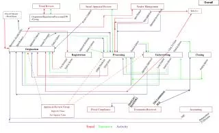
Network Centric Concept Service Oriented Architecture D-AIM Demonstration Arlanda Airport
Service Bus Service Service Service Digital AIM Enterprise Business Layer Standards Users People & Organisations Processes CEO COO System Layer Standards Systems Data System Behaviour D-AIM Demonstration Arlanda Airport
Building Blocks Service Bus Data Data Data Application D-AIM Service D-AIM Demonstration Arlanda Airport
Data Data Data User View Service Bus Application Applications D-AIM Service D-AIM Demonstration Arlanda Airport
Common Service Bus SystemC Service Bus Adapter Example: OGC WFS Interoperable Data Exchange over Common OGC Services System A System B System A Interface User Interface Database D-AIM Demonstration Arlanda Airport
Information Services Mash-ups! Digital AIM Information Service Examples Service combination provides airport situational awareness: Aeronautical Data Digital NOTAM Service AMDB Service Aerodrome Data Weather Data Data Domains Flight Data Flow Data Surveillance Data Environment Data Standardised Services D-AIM Demonstration Arlanda Airport
Service Type ExampleOGC Web Feature Service (WFS) Client WFS Client Standard queries and replies as XML/GML messages over HTTP Reply Request WFS Server Server D-AIM Demonstration Arlanda Airport
Data Sharing Principles Use Provide Interoperable Data Exchange • <Geo-enabled> • <Time-enabled> • <Seamless> • <Open> D-AIM Demonstration Arlanda Airport
« Geo-enabled ATM » D-AIM Flight Information Services AIRCRAFT MOVING MAP Push Pull Push GND Station A Digital AIM DB TVA Pull Pull/Push GND Station B D-AIM Server FIS Server TVB Push GND Station C TVC ATC Closed Airspace Open Airspace D-AIM Demonstration Arlanda Airport
Standardisation • ISO19100 Geospatial Information Standards • Open Geospatial Consortium (OGC) Specifications • World Wide Web Consortium (W3C) Specifications • OASIS Specifications • EUROCAE/RTCA & ARINC Standards • ICAO SARPS • Compliant AIM data models: AIXM5, WXXM,… D-AIM Demonstration Arlanda Airport
D-AIM Enhancements • Improved flexibility to handle expanding data scope • Improved data filtering • Improved data sharing and exchange to remove “stove-pipe” applications • Improved data presentation D-AIM Demonstration Arlanda Airport
Digital AIM - Key projects • Data modelling (AIXM5, WXXM) • Electronic AIP • Terrain and Obstacles Data • Digital Notam • Airport Mapping Database (AMDB) • OpenGIS Testbed • Weather Fusion Demonstrator • D-AIM, Digital AIM Validation D-AIM Demonstration Arlanda Airport