Download
1 / 1
20 likes | 153 Views
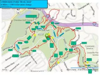
CHEROKEE PARK TRAIL MAP 6 Miles / 1100 ft Elevation change Tshulthise@yahoo.com. Follow road from gravel parking lot, cross bridge then enter woods on the left when you see the trail. Enter woods here. Archery Targets. Gravel Lot. Bridge. Overpass. Enter woods here. Cross road.

E N D
CHEROKEE PARK TRAIL MAP 6 Miles / 1100 ft Elevation change Tshulthise@yahoo.com Follow road from gravel parking lot, cross bridge then enter woods on the left when you see the trail Enter woods here. Archery Targets Gravel Lot Bridge Overpass Enter woods here. Cross road Soccer Field Cross Maple Road here. Cross paved path here. Road Shortcut Maple Road x Road Shortcut x Beargrass Creek Road Shortcut Walk up big grass hill (Dog Hill). x Hogan’s Fountain Paved walking path outdoor pavilion Beargrass Road outdoor pavilion Path crosses (closed) Seminary Road here Follow paved path to woods Small creek crossing Head right on trail behind Hogan’s Fountain Shortcut Seminary Road Paved walking path Tennis Courts Cross Barret Rd. here Enter woods here. Cross Rd. here Cross Scenic Loop Rd. here Cross Scenic Loop Rd. here Cross Scenic Loop Rd. here and walk up stone steps Take path up small hill. Keep left at fork. x x Bridge Exit trail to road. Follow road across the bridge