Download
1 / 17
170 likes | 301 Views
Warm Up 2/6/09. What technology do scientists use to measure ocean depth? a. sonar c. rope b. submersible d. laser Differences in ocean-surface height can be measured by ____. a. satellites c. submersibles b. sonar d. none of the above

E N D
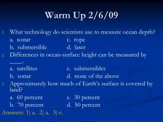
Warm Up 2/6/09 • What technology do scientists use to measure ocean depth? a. sonar c. rope b. submersible d. laser • Differences in ocean-surface height can be measured by ____. a. satellites c. submersibles b. sonar d. none of the above • Approximately how much of Earth’s surface is covered by land? a. 60 percent c. 30 percent b. 70 percent d. 50 percent Answers: 1) a. 2) a. 3) c.
Ocean Floor Features Chapter 14, Section 2
Continental Margins • Continental Margin – the zone of transition between a continent and the adjacent ocean basin floor • In the Atlantic Ocean, thick layers of undisturbed sediment cover the continental margin. This region has very little volcanic or earthquake activity • In the Pacific Ocean, oceanic crust is plunging beneath continental crust. This force results in a narrow continental margin that experiences both volcanic activity and earthquakes
Continental Shelves, Slopes, and Rises • Continental Shelf – the gently sloping submerged surface extending from the shoreline • Continental shelves contain important mineral deposits, large reservoirs of oil and natural gas, and huge sand and gravel deposits • Continental Slope – the seaward edge of the continental shelf • The continental slope is a relatively narrow feature along the continental shelf
Continental Shelves, Slopes, and Rises Continued • Submarine Canyon – deep, steep-sided valleys cut into the continental slope • Turbidity Currents – occasional movements of dense, sediment-rich water down the continental slope • Turbidity currents are known to be an important factor in sediment transfer in the ocean • Continental Rise – a gradual incline which merges with the steep continental margin, occurs in regions where trenches do not exist
Concept Check • Compare and contrast the continental slope and continental rise. • Continental slope marks the steep boundary between continental crust and oceanic crust. The continental rise occurs at the end of the continental slope and has a more gradual incline.
Ocean Basin Floor • Ocean Basin Floor – area between the continental margin and the mid-ocean ridge • Deep-ocean trenches are long, narrow creases in the ocean floor that form the deepest parts of the ocean • Trenches form at sites of plate convergence where one moving plate descends beneath another and plunges back into the mantle • Abyssal Plains – deep, extremely flat features and are the most level places on Earth • The sediments that make up abyssal plains are carried there by turbidity currents or deposited as a result of suspended sediments settling
Ocean Basin Floor Continued • Seamounts – the submerged volcanic peaks which dot the ocean floor • Once underwater volcanoes reach the surface, they form islands • After millions of years, the tops are eroded away and the once active islands sink back into the ocean, forming guyots
Concept Check • What are abyssal plains? • Deep, extremely flat regions of the ocean floor.
Mid-Ocean Ridges • Mid-Ocean Ridge – found near the center of most ocean basins; an interconnected system of underwater mountains that have developed on newly formed ocean crust • Seafloor Spreading – occurs at divergent plate boundaries where two lithospheric plates are moving apart • New ocean floor is formed at mid-ocean ridges as magma rises between the diverging plates and cools • Hydrothermal vents form along mid-ocean ridges and are zones where mineral-rich water escapes through cracks in oceanic crust into the surrounding cooler water
Assignment (Due 2/13) • Read Chapter 14 (pg. 394-413) • Do Chapter 14 Assessment #1-33 (pg. 417-418)
Cool Down • What is formed at mid-ocean ridges? • New ocean floor • Compare and contrast seamounts and guyots. • A seamount is an underwater volcano that has not reached the surface yet. A guyot is a volcanic island that has been eroded and sunk back under the water’s surface. • What is one thing new that you learned today? Explain what it is.