Download
1 / 19
190 likes | 203 Views
Explore classic mathematical problems involving visualizing trajectories, defining circles, and calculating distances on the surface of a sphere for maritime navigation. Utilize simplified methods that are easily understood by students.

E N D
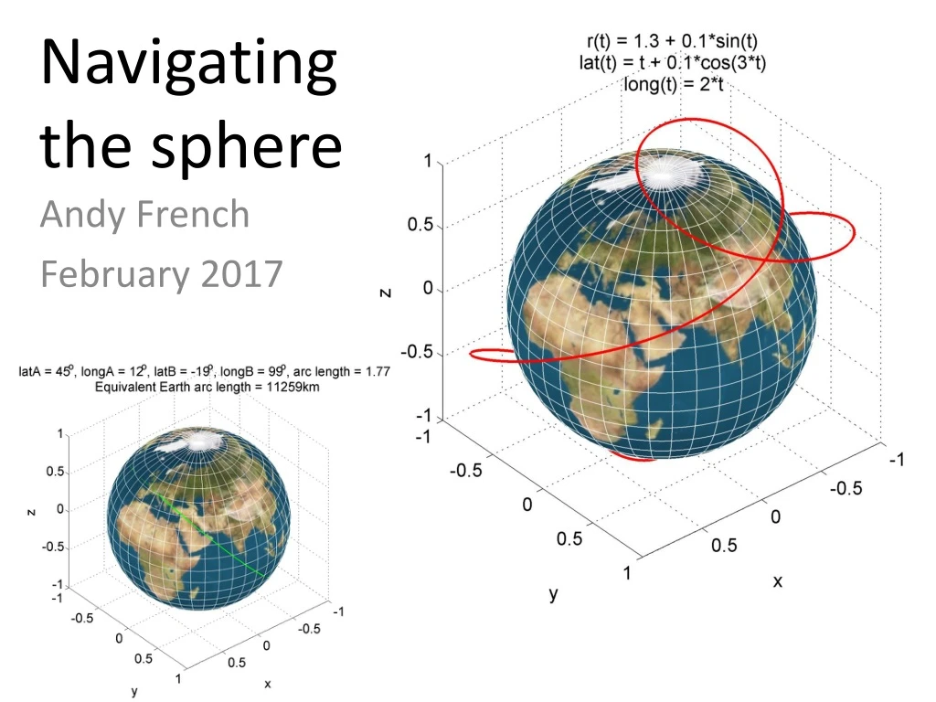
Navigating the sphere Andy French February 2017
Damn! Freddie’s not Cook’s! • Motivation • CSM is working on aspects of maritime navigation with his Div, • and we got chatting on the way to Freddie’s .... • Since to a very good approximation the Earth is spherical* it • occurred to me there are some classic mathematical problems • to solve, and all involve: • Visualizing trajectories defined in spherical polar coordinates • Recipes for defining circles drawn on the surface of a sphere • Transformations between Earth centred Cartesian x,y,z coordinates and a Cartesian ‘East, North, Up’ system where x and y are in the tangent plane to a given latitude l and longitude f. Due to the long history of Navigation there is much estoterica inherent in the textbook solutions to these problems. Can we do it systematically, using methods that a Pre-U student could readily understand? * The polar radius differs from the equatorial radius by a factor of
Three problems 1. Visualize a curve defined parametrically in spherical polar coordinates
This is the general problem with special cases being Great Circles and lines of constant latitude Three problems .... 2. Plot a circle drawn on the surface of a sphere normal Define the circle via the latitude and longitude of a normal to the circle and the anglea between the circumference, sphere centre and normal.
Three problems .... 3. Define the Great Circle arc, which is the shortest distance between two points on the surface of a sphere. Very useful for aircraft or ship routings! Example: London to Hong Kong Accurate distance from Heathrow to Hong Kong Airport is 9,606km Google Maps
Plus an additional frivolous problem .... Is the Force strong enough to give me a parabolic indent in my Death Star? Don’t forget to distort the lines of latitude and longitude too...
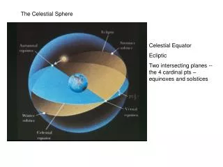
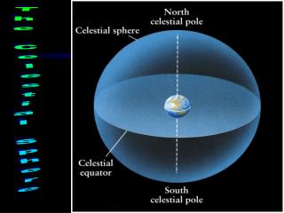
N Spherical polar coordinates latitude Earth Earth centre +ve Latitude E longitude +ve Longitude G Position vector Equator Greenwich Meridian For simplicity, we will use a unit sphere of radius r= 1 Geocentric “Greenwich, East, North” unit vectors – a right handed set.
E f A G Also define a Cartesian coordinate system based upon a local tangent plane to a point on a unit sphere characterized by ‘North’ ‘Up’ ‘East’ i.e. based upon a fixed of the x,y,z system origin Position vector
Parametric trajectory plot MATLAB demo spolartraj.m Position vector For example: MATLAB: plot3(x,y,z)
Circle on a unit sphere The radius of the circle is circle normal Position vector (from origin of sphere*) To plot, define q in (for example) 300 linearly spaced steps between 0 and 2p. Then work out X,Y,Z coordinates. *i.e. not surface in this particular case. This is OK since is a radial vector.
MATLAB demo spherecircle.m Special cases: Lines of Longitude Lines of Latitude Any Great Circle Same code function used to plot all the circles!
unity Great circle arc between two points on a unit sphere Using radians, arc length is Unless the points are on a diameter, we can forma unique normal vector to the great circle between the two points. sphere origin to form a right handed set of basis vectors Set If the points are on a diameter, any Great Circle passing through them will suffice! Position vector Choose b to be the minor arc i.e. the smaller of b and 2p-b
MATLAB demo greatcircle.m Use the arrow keys to modify the latitude and longitude of position 1 and a,z and s,d keys for position 2 Great Circle arc Major arc of Great Circle (green dashed line) To plot we need X,Y,Z in geocentric Cartesians MATLAB: plot3(x,y,z)
Parabolic indent (or cap!) on a sphere (“Death Star Problem”) normal line The Death Star from Star Wars (Diameter 120km) Mimas – a Moon of Saturn (Diameter 396km) Find coordinates on (unit)sphere surface which satisfy: For these points, scale X,Y,Z by Define parabolic indent as a function of the sine of an angle h from normal line
MATLAB demo deathstar.m Use arrow keys to move the indent around in latitude and longitude Press h to toggle wire frame mode Press v to return to textured surface Change size of circle (i.e. a) using a and z keys Change k using k and m keys
Give the Death Star a ‘nose’ if k< 0 Now that Disney has bought the rights to Star Wars... Pinocchio has experienced the dark side of the Force ....
www.eclecticon.info Where to find these resources ...
MATLAB code Presentation Also on Lectures (3) – Click on the icon here