Download
1 / 31
340 likes | 988 Views
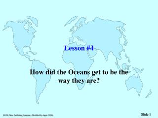
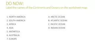
DO NOW: Label the names of the Continents and Oceans on the worksheet map:. 1 . NORTH AMERICA 2. SOUTH AMERICA 3. AFRICA 4. ASIA 5. ANTARTICA 6. AUSTRALIA 7. EUROPE . A . ARCTIC OCEAN B . ATLANTIC OCEAN C . PACIFIC OCEAN D . INDIAN OCEAN. World Geography Week 2.

E N D
DO NOW:Label the names of the Continents and Oceans on the worksheet map: • 1. NORTH AMERICA • 2. SOUTH AMERICA • 3. AFRICA • 4. ASIA • 5. ANTARTICA • 6. AUSTRALIA • 7. EUROPE • A. ARCTIC OCEAN • B. ATLANTIC OCEAN • C. PACIFIC OCEAN • D. INDIAN OCEAN
Review :PHYSICAL GEOGRAPHY • *FOCUSES ON EARTH’S NATURAL ENVIRONMENTS INCLUDING LAND FORMS, WATER FEATURES, PLANTS, ANIMALS, AND OTHER PHYSICAL FEATURES • *STUDIES THE PROCESSES THAT SHAPE THE PHYSICAL ENVIRONMENT
Review:HUMAN GEOGRAPHY • * STUDY OF DISTRIBUTION AND CHARACTERISTICS OF THE WORLD’S PEOPLE • (WHERE PEOPLE LIVE AND WHAT THEY DO) • *EXAMINES HOW PEOPLE MAKE AND TRADE THINGS THAT THEY NEED TO SURVIVE
The globe • A globe is a scale model of Earth. • One of the first things you will notice on the globe is the patterns of lines, east and west , and north south. • Latitude : east-west direction (Parallells) • Longitude: north-south (Meridians) • The intersection of these imaginary lines helps us find the location of places.
Equator and Tropics • Equator: an imaginary line that circles the globe halfway between the north and south pole. • Tropic of Cancer: The parallel 23 ½ degrees north of the equator Tropic of Capricorn: The parallel 23 ½ degrees south of the equator
LATITUDE / LONGITUDE • Latitude is the distance north or south of the equator. • Longitude is the distance east or west of the prime • meridian (Greenwich, England). Latitude and longitude • are measured in seconds, minutes, and degrees: • 60″ (seconds) = 1′ (minute) • 60′ (minutes) = 1° (degree)
PRACTICE • IN YOUR TRIAD GROUPS DETERMINE THE ANSWER THE FOLLOWING: • WHAT IS THE APPROXIMATE LATTITUDE OF THE US/CANADA BORDER FROM WASHINGTON TO MINNESOTA? • WHAT IS THE APPROXIMATE LONGITUDE OF THE EAST COAST • WHAT MAJOR CITY IS LOCATED NEAR 41◦N AND 74◦ W • WHAT COUNTRY IS LOCATED AT 30◦N AND 120◦ E • WHAT OCEAN IS LOCATED AT 15◦S AND 75◦E • THE ARTIC CIRCLE BEGINS AT WHAT LINE OF LATTITUDE? • WHAT IS THE APPROXIMATE LATTITUDE/LONGITUDE OF RIO DE JANEIRO BRAZIL
ANSWERS • 49◦N • 75◦W • NEW YORK • CHINA • INDIAN OCEAN • 70◦N • 23◦S 43 ◦W
DO NOW 9/4/2013 • USING YOUR TEXT BOOK PAGE S36 AND/OR WALL MAPS ANSWER THE FOLLOWING: • What is the approximate latitude/longitude of Damascus Syria? • Name four countries that border Syria. • Name the island nation approx. 15⁰ E of Syria. • What body of water does this nation rest. • What is the straight line distance from Damascus to Ankara Turkey (use distance scale at bottom of map and straight edge paper) • What is the approx. latitude/longitude of Ankara Turkey
Answers • What is the approximate latitude/longitude of Damascus Syria? • 33N 36E • Name four countries that border Syria. • TURKEY, IRAQ, JORDAN, ISRAEL LEBANON • Name the island nation approx. 15⁰ W of Syria. • CYPRUS • What body of water does this island nation rest. • MEDITERRANEAN SEA • What is the straight line distance from Damascus to Ankara Turkey (use distance scale at bottom of map and straight edge paper) • 500 MI, 805KM • What is the approx. latitude/longitude of Ankara Turkey • 39N 32E
LATITUDE / LONGITUDE BROKEN DOWN • There are 60 minutes (') per degree, and 60 seconds (") per minute • A coordinate might be written 65° 32' 15“ • Degrees can also be expressed as decimals: 65.5375 • Degrees and decimal minutes: 65° 32.25‘ • Degrees, minutes, and decimal seconds: 65° 32' 15.275“ • All these notations allow us to locate places on the Earth quite precisely – to within inches
LATITUDE BROKEN DOWN • A degree of latitude is approximately 69 miles. • A minute of latitude is approximately 1.15 miles • A second of latitude is approximately 0.02 miles, or just over 100 feet.
LONGITUDE BROKEN DOWN • A degree of longitude varies in size. • At the equator, it is approximately 69 miles, the same size as a degree of latitude. • The size gradually decreases to zero as the meridians converge at the poles. • At a latitude of 45 degrees, a degree of longitude is approximately 49 miles. • Because a degree of longitude varies in size, minutes and seconds of longitude also vary, decreasing in size towards the poles.
HEMISPHERES HEMISPHERE: HALVES OF THE GLOBE DIVIDED BY THE EQUATOR AND PRIME MERIDIAN PRIME MERIDIAN: IMAGINARY LINE DRAWN FROM THE NORTH POLE THROUGH GREENWICH,ENGLAND, TO THE SOUTH POLE. THE FOUR HEMISPHERES ARE: • NORTHERN HEMISPHERE • SOUTHERN HEMISPHERE • EASTERN HEMISPHERE • WESTERN HEMISPHERE
MAP PROJECTIONS • CYLINDRICAL • DESIGNED AS IF A CYLINDER HAS BEEN WRAPED AROUND THE GLOBE • MERIDIANS ARE PULLED APART AND ARE PARALLEL TO EACH OTHER INSTEAD OF MEETING AT THE POLES (CAUSES LANDMASS DISTORTION TOWARDS THE POLES) • EXAMPLE MERCATOR MAP • BENEFITS: SHOWS TRUE DIRECTION AND SHAPE • CONICAL • DESIGNED AS IF A CONE HAS BEEN PLACED OVER THE GLOBE. • ACCURATE ALONG THE LINES OF LATITUDE WHERE IT TOUCHES THE GLOBE. • RETAINS ALMOST TRUE SHAPES AND SIZES OF LANDMASSES • BENEFITS: MOST USEFUL FOR AREAS THAT HAVE LONG EAST-WEST DIMENSIONS (U.S. RUSSIA)
MAP PROJECTIONS • FLAT-PLANE (PLANAR) • APPEAR TO TOUCH THE GLOBE AT ONE POINT SUCH AS THE NORTH POLE/SOUTH POLE • USEFUL FOR SHOWING TRUE DIRECTION (AIRPLANE PILOTS/SHIP NAVIGATORS) • SHOWS TRUE AREA SIZES, BUT DISTORTS SHAPES.
REVIEW • http://olc.spsd.sk.ca/DE/k9mod/Mapskill/mod3fl5.swf
DO NOW: USE BOOK PG S38 9/5/2013!!TEST WED 9/11/2013!!! • 1. What Country Is Located At 0⁰ 20⁰e • 2. What Is The Capital Of The Country In Question 1? • 3. What Country Is Located At 30 ⁰N 30 ⁰E? • 4. What Seas Border This Nation In Question 3? • 5. What Major River Runs Through This Nation In Question 3? • 6. What Is The Approximate Lat/Long Of Cape Town S Africa? • 7.What Is The Straight Line Distance From Capetown S Africa To Windhoek Nambia?
Answers • Democratic Republic Of The Congo • Kinshasa • Egypt • Mediterranean Sea, Red Sea • Nile • 34s 18e • 750mi / 1300 Km
Key words • Planets- major bodies that orbit a star • Solar System- The Sun and group of bodies that revolve it • Moons- smaller objects that orbit a planet (may also be called a satellite)
Earth’s Four Sphere’s • Atmosphere- Envelope of gases that surrounds Earth • Lithosphere- Solid crust of the planet • Hydrosphere –All of Earth’s Water • Biosphere- All of Earth’s life forms