HURACAN EYE
HURACAN EYE. WHAT IS A HURRICANE, TYPHOON, OR TROPICAL CYCLONE? http://www.nhc.noaa.gov/.

HURACAN EYE
E N D
Presentation Transcript
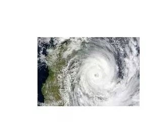
WHAT IS A HURRICANE, TYPHOON, OR TROPICAL CYCLONE?http://www.nhc.noaa.gov/ • The terms "hurricane" and "typhoon" are regionally specific names for a strong "tropical cyclone". A tropical cyclone is the generic term for a non-frontal synoptic scale low-pressure system over tropical or sub-tropical waters with organized convection (i.e. thunderstorm activity) and definite cyclonic surface wind circulation (Holland 1993). • Once the tropical cyclone reaches winds of at least 17 m/s (34 kt, 39 mph) they are typically called a "tropical storm" and assigned a name. If winds reach 33 m/s (64 kt, 74 mph)), then they are called: "hurricane" (the North Atlantic Ocean, the Northeast Pacific Ocean east of the dateline, or the South Pacific Ocean east of 160E) "typhoon" (the Northwest Pacific Ocean west of the dateline) "severe tropical cyclone" (the Southwest Pacific Ocean west of 160E or Southeast Indian Ocean east of 90E) "severe cyclonic storm" (the North Indian Ocean) "tropical cyclone" (the Southwest Indian Ocean) (Neumann 1993). Contributed by Chris Landsea
¿QUÉ ES UN HURACÁN TIPO CABO VERDE?http://www.nhc.noaa.gov/ • Cape Verde-type hurricanes are those Atlantic basin tropical cyclones that develop into tropical storms fairly close (<1000 km [600 mi] or so) of the Cape Verde Islands and then become hurricanes before reaching the Caribbean. (That would be my definition, there may be others.) Typically, this may occur in August and September, but in rare years (like 1995) there may be some in late July and/or early October. The numbers range from none up to around five per year - with an average of around 2. • Contributed by Chris Landsea
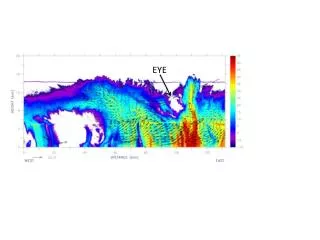
RECORRIDO DE UN HURACÁN “CABO VERDE”http://www.nhc.noaa.gov/
DESDE 1949 EN EL PACÍFICO Y DESDE 1851 EN EL ATLÁNTICOhttp://www.nhc.noaa.gov/
Number of Tropical Cyclones per 100 Years http://www.nhc.noaa.gov/