Download
1 / 4
40 likes | 185 Views
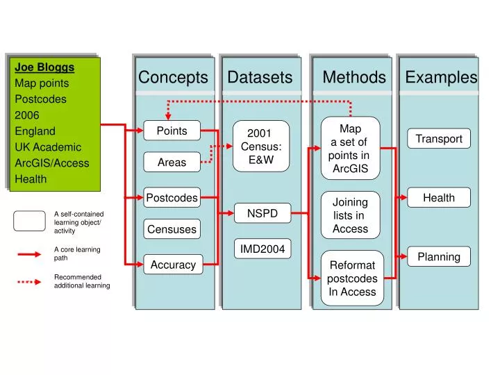
Joe Bloggs Map points Postcodes 2006 England UK Academic ArcGIS/Access Health. Concepts. Datasets. Methods. Examples. Map a set of points in ArcGIS. Points. 2001 Census: E&W. Transport. Areas. Postcodes. Health. Joining lists in Access. NSPD.

E N D
Joe Bloggs Map points Postcodes 2006 England UK Academic ArcGIS/Access Health Concepts Datasets Methods Examples Map a set of points in ArcGIS Points 2001 Census: E&W Transport Areas Postcodes Health Joining lists in Access NSPD A self-contained learning object/ activity Censuses IMD2004 A core learning path Planning Reformat postcodes In Access Accuracy Recommended additional learning
Joe Bloggs Map points Postcodes 2006 England UK Academic ArcGIS/Access Health Concepts Datasets Methods Examples Map a set of points in ArcGIS Points 2001 Census: E&W Transport Areas Postcodes Health Joining lists in Access NSPD A self-contained learning object/ activity Censuses IMD2004 A core learning path Planning Reformat postcodes In Access Accuracy Recommended additional learning
Joe Bloggs Map points Postcodes 2006 England UK Academic ArcGIS/Access Health Concepts Datasets Methods Examples Map a set of points in ArcGIS Points 2001 Census: E&W Transport Areas Postcodes Health Joining lists in Access NSPD A self-contained learning object/ activity Censuses IMD2004 A core learning path Planning Reformat postcodes In Access Map scale Recommended additional learning
Concepts Datasets Methods Examples Jenny Bloggs Linkage, map PC, census 2001-6 England UK Academic ArcGIS Health Censuses Census 2001 England Mapping areas Transport Areas Housing Census 2001 Wales Joining lists Postcodes Health Points NSPD GeoConvert Education Accuracy IMD2004 Reformatting postcodes Planning