Download
1 / 1
10 likes | 132 Views
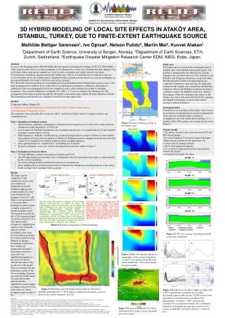
Figure 1 Scetch of surface geology in the Ataköy area. a). b). c). d). Scenario earthquake. Figure 5 Scenario earthquake [7]. Colors show the PGV at bedrock level calculated from the scenario.

E N D
Figure 1 Scetch of surface geology in the Ataköy area. a) b) c) d) Scenario earthquake Figure 5 Scenario earthquake [7]. Colors show the PGV at bedrock level calculated from the scenario. 3D HYBRID MODELING OF LOCAL SITE EFFECTS IN ATAKÖY AREA, ISTANBUL, TURKEY, DUE TO FINITE-EXTENT EARTHQUAKE SOURCEMathilde Bøttger Sørensen1, Ivo Oprsal2, Nelson Pulido3, Martin Mai2, Kuvvet Atakan11Department of Earth Science, University of Bergen, Norway, 2Department of Earth Sciences, ETH, Zurich, Switzerland, 3Earthquake Disaster Mitigation Research Center EDM, NIED, Kobe, Japan. Abstract As part of the European project RELIEF (RELiable Information on Earthquake Faulting, EVG1-CT-2002-00069), a study of the possible effects of a large earthquake in the Marmara Sea on the city of Istanbul has been initiated. This study deals with ground motion simulations, local site effect estimation and seismic hazard assessment.Ground motion simulations are performed in the Ataköy area, which is located between two alluvial systems in western Istanbul, next to the Atatürk airport. Simulated bedrock ground motions based on a scenario earthquake are propagated through a 3D model of the local near surface geology. The 3D model is based on geological, geomorphological and geotechnical data obtained from various sources. The input ground motion at bedrock level is the result of a ground motion simulation combining a deterministic simulation of the wave propagation for the low frequencies with a semi-stochastic procedure for the high frequencies. The scenario earthquake is assumed to be a Mw = 7.5 event occurring in the Marmara Sea. The propagation of the bedrock motion through the 3D model is performed using a hybrid 3D finite difference scheme.The computed ground motions are compared to results from other approaches. Study area The Ataköy area is located in the westernmost part of Istanbul, next to the Atatürk international airport. The geology is dominated by two alluvial river systems running to the east and to the west. Two formations, the Bakirköy and Güngören formations, are present under the alluvium above bedrock. Both formations are composed of limestone, marl and clay, the Güngören formation with a higher clay content than the Bakirköy formation, whereas the Bakirköy formation has higher carbonate content. The Bakirköy formation, which is the youngest of the two, dominates the surface in the Ataköy area, but erodes away towards North, exposing the Güngören formation. A scetch of the surface geology is shown in Figure 1. • Method • 2 step procedure (Figure 4): • Simulation of ground motion at bedrock level due to finite extent source • Evaluation of local site effects • This separates source and path effects from site effects and thereby reduces need of computer memory and computation time. • Step 1: Simulation of bedrock motion • Hybrid method combining a deterministic simulation at low frequencies (0.1-1 Hz) with a semi-stochastic simulation at high frequencies (1-10 Hz) [6] • Low frequencies: Subfault contributions are calculated using discrete wave number theory [2] and summed assuming constant rupture velocity • High frequencies: Subfault contributions are calculated using stochastic method of Boore [1] and summed using empirical Greens function method of Irikura [3]. Radiation pattern is changed from theoretical double couple at low frequencies to uniform radiation pattern at high frequencies. • Gives ground motion on ‘excitation box’ surrounding site of interest • Scenario earthquake: worst case scenario determined from previous studies (Figure 5) • Step 2: Evaluation of local site effects • 3D finite difference scheme on irregular rectangular grid [4,5] • One FD approximation everywhere (easy to implement), thus the topographic free surface is approximated by the vacuum formalism • Uses local geological model and bedrock motion on ‘excitation box’ • Gives amplification of ground motion relative to bedrock site obtained by extending bedrock to the surface • Stable for high Vp/Vs and high Vp/Vs contrasts Geological model The model of local geology in the Ataköy area is based on geological, geomorphological and geotechnical data. These data are combined under a number of assumptions to give the model shown in Figure 2. A number of East-West going cross sections are shown in Figure 3. • Velocity model • The surface velocities are constrained from CPT and SPT measurements. • For each formation, Vs increases linear with depth • High velocity gradient for the uppermost 5 m • Lower velocity gradient at depth • Vp/Vs from emperical relations • is constant at depth and decreases exponentially towards the surface • at depth from emperical values Results The shape and the complexity of the sedimentary layers cause some numerical instabilities in the FD modeling implying that reliable results have only been obtained for the frequency interval 3-5 Hz. There is an ongoing effort to overcome these problems in order to reach a reliable solution for a broader frequency band. The simulation results for the 3-5 Hz frequency band are shown in Figure 6. It is seen that for these frequencies, amplification mainly occurs along the alluvial systems. In parallel to this study, local site effects in Ataköy have been estimated using different techniques. Preliminary results from these studies are summarized in Figure 7. From these results it is expected to see amplification mainly at 1 Hz and at 3-6 Hz for alluvial sites and at 1 Hz for the rest of the model. This is consistent with the preliminary results of the above modeling. Standard spectral ratio results based on weak-motion data indicate that the amplification can be higher (as high as a factor of 10 in some cases) at a lower frequency range around 0.5 Hz. Figure 4 Schematic description of hybrid modeling Figure 3 E-W cross sections of geological model used in the simulations. Figure 2 Maps showing the subsurface topography of the various formations as a part of the geological model used in the simulations. Colors show depth to layer in meters. Figure 6 Preliminary spectral amplification results for 3D hybrid modeling performed for 3-5 Hz frequency. Amplification mainly occurs at alluvial sites for this frequency interval. Figure 7 Results from site effect studies in Ataköy [8]. a) H/V spectral ratio calculated for recorded microtremor data at alluvial sites. b) H/V spectral ratio calculated for modeled noise at an alluvial site representative of Ataköy. c) H/V spectral ratio calculated for recorded microtremor data at Bakirköy formation. d) Standard spectral ratio results for two stations on Bakirköy formation relative to a bedrock site. References: [1] Boore, D. M. (1983): Stochastic simulation of high frequency ground motions based on seismological models of the radiated spectra, Bull. Seism. Soc. Am., 73, 1865-1894 [2] Bouchon, M. (1981): A simple method to calculate Green’s functions for elastic layered media, Bull. Seism. Soc. Am., 71, 959-971 [3] Irikura, K. (1986): Prediction of strong acceleration motion using empirical Green’s function, Proceedings of the 7th Japan. Earthq. Eng. Symp., 151-156 [4] Oprsal, I and Zahradnik, J. (2002): Three-dimensional finite difference method for modeling of earthquake ground motion, Journal of Geophysical Research, Vol. 107 [5] Oprsal, I., Brokesova, J., Fäh, D. and Domenico, G. (2002): 3D hybrid ray-FD and DWN-FD seismic modeling for simple models containing complex local structures, Stud. Geophys. Geod., 46, 711-730 [6] Pulido, N. and Kubo, T. (2004): Near-fault strong motion complexity of the 2000 Tottori earthquake (Japan) from a broadband source asperity model, Tectonophysics, In press [7] Pulido, N., Ojeda, A., Atakan, K. and Kubo, T. (2004): Strong ground motion estimation in the Sea of Marmara region (Turkey) based on a scenario earthquake, Tectonophysics, In press [8] Sørensen, M. B., Bonnefoy-Claudet, S., Atakan, K. and Yalciner, C. (2004): Local site effects and noise characteristics in Ataköy area, Istanbul, Turkey, Oral presentation at ESC2004 meeting, Potsdam, 12-17 September 2004.