Download
1 / 10
100 likes | 219 Views
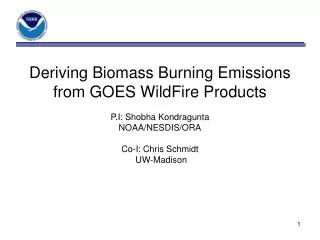
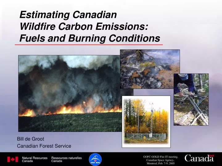
Estimating Canadian Wildfire Carbon Emissions: Fuels and Burning Conditions. Bill de Groot Canadian Forest Service. AB SK MB. Montreal Lake Fire Burn 104 NBR Image. Landsat TM 37-22 Imaged: August 26/03 Orthorectification: CCRS NBR range: 1.34. Jack Pine: Crown Fire

E N D
Estimating Canadian Wildfire Carbon Emissions: Fuels and Burning Conditions Bill de Groot Canadian Forest Service
AB SK MB Montreal Lake Fire Burn 104 NBR Image Landsat TM 37-22 Imaged: August 26/03 Orthorectification: CCRS NBR range: 1.34
Jack Pine: Crown Fire Carbon Emission Range Forest Overstory Carbon storage: X-XX t/ha Emissions rate: XX-XX% (X-XX t/ha) Total C Emission: X-XX t/ha Forest Floor Carbon storage: 2-28 t/ha Emissions rate: 28-74% (1-14 t/ha)
Effect of Different Fuel Types Fire Weather Index = 17 for both fires Jack pine Carbon storage: X-XX t/ha Carbon Emissions: X-XX t/ha Black Spruce Carbon storage: X-XX t/ha Carbon Emissions: X-XX t/ha
Carbon Emission Modeling Requirements • Fuels data • fuel type, fuel load • Burning conditions • Fire Weather Index data
Fuel Type Data • Provincial/Territorial forest inventory • National Fuels Map (SPOT-VGT)
Fuel Load Data • Provincial/Territorial forest inventory • National Fuels Map (SPOT-VGT) • Canadian Forest Inventory (CANFI) • Carbon Budget Model for the Canadian Forest Sector (CBM-CFS3)
Atmosphere Snag stems Snag stems Snag branches Fallen Logs Snag branches Stemwood Stemwood Dead Branches Bark, branches & submerchantable Bark, branches and submerchantable trees Litter, Fine Roots Slow DOM Foliage Foliage Black carbon Fine roots Fine roots Fast DOM Slow DOM Coarse roots Coarse roots Very fast DOM Structure of the CBM-CFS3 Above mineral soil Live trees Dead & down woody debris Forest floor and soil OM Standing dead trees
Boreal Fire Effects Model (BORFIRE) and CBM-CFS3 Fire Event • Fire emissions by pool • Transfers between pools • Mortality and regeneration BORFIRE Pre-fire fuel status Post-fire stand and carbon dynamics CBM-CFS3 New carbon pool status
Daily National Weather Data Daily Burned Area (MODIS, AVHRR hotspots) National Fuels Map, Spatial Area Burned (SPOT-VGT) Fuels Databases Daily Burning Conditions Fire Weather Index System Fuel types Canadian Wildland Fire Information System Remotely Sensed Data BORFIRE Pre-fire fuel load Carbon emissions and pool transfers Fire Event Post-fire stand and carbon dynamics CBM-CFS3 New carbon pool status