Open Source Geo Tools Tyler Mitchell
Open Source Geo Tools Tyler Mitchell. Tyler Mitchell. Geographer Open Source Geospatial Advocate GIS Manager at Timberline, B.C. Author Web Mapping Illustrated Using Open Source GIS Toolkits (O'Reilly). Data Components. Spatial data access API. Real-time apps. Databases. Files.

Open Source Geo Tools Tyler Mitchell
E N D
Presentation Transcript
Open Source Geo Tools Tyler Mitchell
Tyler Mitchell Geographer Open Source Geospatial Advocate GIS Manager at Timberline, B.C. Author Web Mapping Illustrated Using Open Source GIS Toolkits (O'Reilly)
Data Components Spatial data access API Real-time apps Databases Files
Data Components C C++ Images WMS Python WFS Geospatial Data Abstraction Layer (GDAL) MapServer / GeoServerfor web services Shape files GeoTIFF GML/XML CSV/Text Real-time GPS Web Services Search PostgreSQLPostGIS MySQL
Functional Components Visualisation Analysis Manipulation Creation Data Conversion
Data Creation Creation Data
Data Creation Creation Data
Conversion Raster conversion > gdal_translate -of GTiff input.jpg output.tif > gdal_translate -of ECW input.jpg output.ecw Vector conversion > ogr2ogr -f GML output.gml input.shp Conversion Data
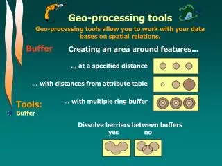
Manipulation Raster clip > gdal_translate -projwin -122.19 52.21 -122.08 52.11 input_dem.tif output_clip.tif Manipulation Data
Manipulation PostGIS query to buffer points > CREATE TABLE station_areas AS ( SELECT buffer(geo_points,2) FROM stations WHERE.. Manipulation Data
Analysis Analysis Data
Analysis PostGIS query to analysis distances > SELECT county.name FROM counties, stations WHERE distance(counties.geo, stations.geo) < 10 AND stations.power > 150; name ----------- Barnstable Dukes Nantucket Plymouth Analysis Data
Analysis Analysis Data
Visualisation Visualisation Data
Visualisation Visualisation Data
Visualisation Visualisation Data
Visualisation Visualisation Data
Visualisation Visualisation Data
Watch For... Continued progress of GDAL Desktop GIS/mapping to stabilise Further consolidation Bridging between OSGeo/commercial Web service platforms (OWS) GUI to spatial database functions "Foundation" development
Contact & Follow-up MapTools.org FreeGIS.org O'Reilly Network Weblogoreillynet.com tylermitchell@shaw.ca